Estimated Value: $530,473 - $596,000
3
Beds
2
Baths
1,960
Sq Ft
$287/Sq Ft
Est. Value
About This Home
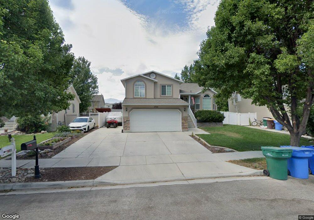
This home is located at 1721 N 2560 W, Lehi, UT 84043 and is currently estimated at $563,118, approximately $287 per square foot. 1721 N 2560 W is a home located in Utah County with nearby schools including North Point Elementary School, Willowcreek Middle School, and Lehi High School.
Ownership History
Date
Name
Owned For
Owner Type
Purchase Details
Closed on
Jul 14, 2021
Sold by
Little Brendon
Bought by
Little Brandon
Current Estimated Value
Home Financials for this Owner
Home Financials are based on the most recent Mortgage that was taken out on this home.
Original Mortgage
$313,000
Outstanding Balance
$283,999
Interest Rate
2.9%
Mortgage Type
New Conventional
Estimated Equity
$279,119
Purchase Details
Closed on
Jul 2, 2019
Sold by
Tsouras Cory and Tsouras Rochelle
Bought by
Little Brendon
Home Financials for this Owner
Home Financials are based on the most recent Mortgage that was taken out on this home.
Original Mortgage
$318,250
Interest Rate
4%
Mortgage Type
New Conventional
Purchase Details
Closed on
Oct 8, 2014
Sold by
Jeffs Tera L
Bought by
Tsouras Cory and Tsouras Rochelle
Home Financials for this Owner
Home Financials are based on the most recent Mortgage that was taken out on this home.
Original Mortgage
$230,359
Interest Rate
4.08%
Mortgage Type
VA
Purchase Details
Closed on
May 19, 2009
Sold by
Jeffs Tera L
Bought by
Jeffs Tera L
Purchase Details
Closed on
Oct 1, 2008
Sold by
Jeffs Kevin B and Jeffs Tera L
Bought by
Jeffs Tera L
Purchase Details
Closed on
Feb 27, 2008
Sold by
Anderson Doran C and Anderson Alish F
Bought by
Jeffs Kevin B and Jeffs Tera L
Home Financials for this Owner
Home Financials are based on the most recent Mortgage that was taken out on this home.
Original Mortgage
$210,000
Interest Rate
5.65%
Mortgage Type
Purchase Money Mortgage
Purchase Details
Closed on
Mar 16, 2006
Sold by
Labrum Steven C and Labrum Veronica R
Bought by
Anderson Doran C and Anderson Alish F
Home Financials for this Owner
Home Financials are based on the most recent Mortgage that was taken out on this home.
Original Mortgage
$150,000
Interest Rate
6.19%
Mortgage Type
Fannie Mae Freddie Mac
Purchase Details
Closed on
Oct 22, 2002
Sold by
Labrum Steven C
Bought by
Labrum Steven C and Labrum Veronica R
Home Financials for this Owner
Home Financials are based on the most recent Mortgage that was taken out on this home.
Original Mortgage
$151,616
Interest Rate
6.09%
Mortgage Type
FHA
Purchase Details
Closed on
Oct 9, 2002
Sold by
Woodside Homes Corp
Bought by
Labrum Steven C
Home Financials for this Owner
Home Financials are based on the most recent Mortgage that was taken out on this home.
Original Mortgage
$151,616
Interest Rate
6.09%
Mortgage Type
FHA
Create a Home Valuation Report for This Property
The Home Valuation Report is an in-depth analysis detailing your home's value as well as a comparison with similar homes in the area
Home Values in the Area
Average Home Value in this Area
Purchase History
| Date | Buyer | Sale Price | Title Company |
|---|---|---|---|
| Little Brandon | -- | Cottonwood Title Ins Agency | |
| Little Brendon | -- | Title Guarantee River Park | |
| Tsouras Cory | -- | Inwest Title | |
| Jeffs Tera L | -- | Meridian Title Company Lehi | |
| Jeffs Tera L | -- | Greenbrier Title Insurance | |
| Jeffs Kevin B | -- | United Title Services | |
| Anderson Doran C | -- | United Title Services | |
| Labrum Steven C | -- | First American Title Co | |
| Labrum Steven C | -- | First American Title Co |
Source: Public Records
Mortgage History
| Date | Status | Borrower | Loan Amount |
|---|---|---|---|
| Open | Little Brandon | $313,000 | |
| Closed | Little Brendon | $318,250 | |
| Previous Owner | Tsouras Cory | $230,359 | |
| Previous Owner | Jeffs Kevin B | $210,000 | |
| Previous Owner | Anderson Doran C | $150,000 | |
| Previous Owner | Labrum Steven C | $151,616 |
Source: Public Records
Tax History Compared to Growth
Tax History
| Year | Tax Paid | Tax Assessment Tax Assessment Total Assessment is a certain percentage of the fair market value that is determined by local assessors to be the total taxable value of land and additions on the property. | Land | Improvement |
|---|---|---|---|---|
| 2025 | $2,026 | $251,570 | $178,700 | $278,700 |
| 2024 | $2,026 | $237,050 | $0 | $0 |
| 2023 | $1,909 | $242,605 | $0 | $0 |
| 2022 | $2,029 | $249,920 | $0 | $0 |
| 2021 | $1,820 | $338,900 | $103,400 | $235,500 |
| 2020 | $1,716 | $315,800 | $95,700 | $220,100 |
| 2019 | $1,500 | $287,100 | $95,700 | $191,400 |
| 2018 | $1,471 | $266,200 | $85,400 | $180,800 |
| 2017 | $1,440 | $138,545 | $0 | $0 |
| 2016 | $1,401 | $125,015 | $0 | $0 |
| 2015 | $1,346 | $114,015 | $0 | $0 |
| 2014 | -- | $109,835 | $0 | $0 |
Source: Public Records
Map
Nearby Homes
- 1696 N 2640 W
- Huntington Plan at Pioneer Meadows
- Silver Lake Plan at Pioneer Meadows
- Summit Plan at Pioneer Meadows
- Palisade Plan at Pioneer Meadows
- 1870 N 2230 W
- 1896 N 2230 W
- 1908 N 2230 W
- 2189 N 2600 W
- 1302 N 2450 W
- 1970 N 2090 St W
- Accord Plan at Riverwalk
- Interlude Plan at Riverwalk
- Trio Plan at Riverwalk
- Fortissimo Plan at Riverwalk
- Ballad Plan at Riverwalk
- Tenor Plan at Riverwalk
- Madrigal Plan at Riverwalk
- Timpani Plan at Riverwalk
- Canon Plan at Riverwalk