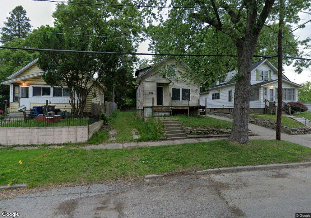
1721 Pennsylvania Ave Flint, MI 48506
Eastside NeighborhoodEstimated Value: $40,000 - $44,000
2
Beds
2
Baths
792
Sq Ft
$53/Sq Ft
Est. Value
About This Home
This home is located at 1721 Pennsylvania Ave, Flint, MI 48506 and is currently estimated at $42,000, approximately $53 per square foot. 1721 Pennsylvania Ave is a home located in Genesee County with nearby schools including Doyle/Ryder School, Flint Cultural Center Academy, and WAY Academy of Flint.
Ownership History
Date
Name
Owned For
Owner Type
Purchase Details
Closed on
Sep 23, 2025
Sold by
Genesee County Land Bank Authority
Bought by
Lawler Aaron Lee
Current Estimated Value
Purchase Details
Closed on
Dec 17, 2015
Sold by
Genesee County
Bought by
Genesee County Land Bank
Purchase Details
Closed on
May 24, 2005
Sold by
Brackin Ronnie
Bought by
Wruck Jim and Strong Alicia Ann
Purchase Details
Closed on
Aug 3, 2000
Sold by
Roda Matthew L and Roda Deborah A
Bought by
Brackin Ronnie
Purchase Details
Closed on
Mar 4, 1999
Sold by
Tabor Arthur W and Tabor Marjorie M
Bought by
Roda Matthew L and Roda Deborah A
Create a Home Valuation Report for This Property
The Home Valuation Report is an in-depth analysis detailing your home's value as well as a comparison with similar homes in the area
Home Values in the Area
Average Home Value in this Area
Purchase History
| Date | Buyer | Sale Price | Title Company |
|---|---|---|---|
| Lawler Aaron Lee | $3,500 | None Listed On Document | |
| Genesee County Land Bank | -- | None Available | |
| Wruck Jim | -- | Metropolitan Title Company | |
| Brackin Ronnie | $2,000 | Guaranty Title Company | |
| Roda Matthew L | -- | Guaranty Title Company |
Source: Public Records
Tax History Compared to Growth
Tax History
| Year | Tax Paid | Tax Assessment Tax Assessment Total Assessment is a certain percentage of the fair market value that is determined by local assessors to be the total taxable value of land and additions on the property. | Land | Improvement |
|---|---|---|---|---|
| 2025 | -- | $0 | $0 | $0 |
| 2024 | -- | $0 | $0 | $0 |
| 2023 | -- | $0 | $0 | $0 |
| 2022 | $0 | $0 | $0 | $0 |
| 2021 | $0 | $0 | $0 | $0 |
| 2020 | $0 | $0 | $0 | $0 |
| 2019 | $0 | $0 | $0 | $0 |
| 2018 | $0 | $0 | $0 | $0 |
| 2017 | $2,544 | $0 | $0 | $0 |
| 2016 | $0 | $0 | $0 | $0 |
| 2015 | -- | $0 | $0 | $0 |
| 2014 | -- | $0 | $0 | $0 |
| 2012 | -- | $7,100 | $0 | $0 |
Source: Public Records
Map
Nearby Homes
- 1318 Cronk Ave
- 1644 Pennsylvania Ave
- 1220 Minnesota Ave
- 1605 Kearsley Park Blvd
- 1501 Arlington Ave
- 1612 Iowa Ave
- 1622 Arlington Ave
- 1510 N Vernon Ave
- 1445 Kearsley Park Kearsley Park
- 2301 Missouri Ave
- 1529 Broadway Blvd
- 1379 Washington Ave
- 2426 Missouri Ave
- 1805 Bennett Ave
- 1814 Mabel Ave
- 2225 Arlington Ave
- 2610 Pennsylvania Ave
- 2605 Nebraska Ave
- 301 Chandler St
- 1513 Jane Ave
- 1725 Pennsylvania Ave
- 1717 Pennsylvania Ave
- 1713 Pennsylvania Ave
- 1722 Ohio Ave
- 1724 Ohio Ave
- 1709 Pennsylvania Ave
- 1733 Pennsylvania Ave
- 1730 Ohio Ave
- 1720 Ohio Ave
- 1718 Ohio Ave
- 1710 Ohio Ave
- 1734 Ohio Ave
- 1401 Cronk Ave
- 1408 Minnesota Ave
- 1730 Pennsylvania Ave
- 1706 Ohio Ave
- 1705 Pennsylvania Ave
- 1413 Cronk Ave
- 1701 Pennsylvania Ave
- 1710 Pennsylvania Ave