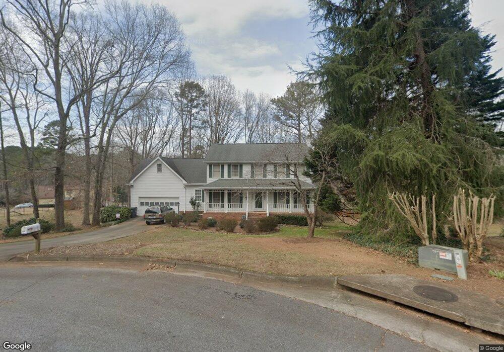
1721 Stonetrace Ct Unit 1 Lawrenceville, GA 30043
Estimated Value: $405,000 - $471,000
3
Beds
3
Baths
2,097
Sq Ft
$209/Sq Ft
Est. Value
About This Home
This home is located at 1721 Stonetrace Ct Unit 1, Lawrenceville, GA 30043 and is currently estimated at $437,928, approximately $208 per square foot. 1721 Stonetrace Ct Unit 1 is a home located in Gwinnett County with nearby schools including Taylor Elementary School, Creekland Middle School, and Collins Hill High School.
Ownership History
Date
Name
Owned For
Owner Type
Purchase Details
Closed on
Feb 26, 1998
Sold by
Mccord Ronald W and Mccord Carol E
Bought by
Mcintyre Andrew J
Current Estimated Value
Home Financials for this Owner
Home Financials are based on the most recent Mortgage that was taken out on this home.
Original Mortgage
$137,750
Outstanding Balance
$23,759
Interest Rate
7.07%
Mortgage Type
New Conventional
Estimated Equity
$414,169
Create a Home Valuation Report for This Property
The Home Valuation Report is an in-depth analysis detailing your home's value as well as a comparison with similar homes in the area
Home Values in the Area
Average Home Value in this Area
Purchase History
| Date | Buyer | Sale Price | Title Company |
|---|---|---|---|
| Mcintyre Andrew J | $145,000 | -- |
Source: Public Records
Mortgage History
| Date | Status | Borrower | Loan Amount |
|---|---|---|---|
| Open | Mcintyre Andrew J | $137,750 |
Source: Public Records
Tax History Compared to Growth
Tax History
| Year | Tax Paid | Tax Assessment Tax Assessment Total Assessment is a certain percentage of the fair market value that is determined by local assessors to be the total taxable value of land and additions on the property. | Land | Improvement |
|---|---|---|---|---|
| 2025 | $4,109 | $163,600 | $31,200 | $132,400 |
| 2024 | $3,938 | $174,880 | $31,200 | $143,680 |
| 2023 | $3,938 | $153,160 | $31,200 | $121,960 |
| 2022 | $3,686 | $138,120 | $31,200 | $106,920 |
| 2021 | $2,718 | $88,240 | $16,960 | $71,280 |
| 2020 | $2,718 | $88,240 | $16,960 | $71,280 |
| 2019 | $2,660 | $88,240 | $16,960 | $71,280 |
| 2018 | $2,661 | $88,240 | $16,960 | $71,280 |
| 2016 | $2,213 | $66,560 | $12,400 | $54,160 |
| 2015 | $2,235 | $66,560 | $12,400 | $54,160 |
| 2014 | $2,069 | $58,600 | $12,440 | $46,160 |
Source: Public Records
Map
Nearby Homes
- 270 Hambridge Ct Unit 1
- 83 Russell Rd
- 81 Russell Rd
- 1702 Windsor Chase Ct
- 1932 Riverton Dr
- 374 Oak Springs Dr
- 1924 Sidneys Cove
- 1825 Marsh Creek Dr
- 362 Inwood Trail
- 525 Provence Gate Ln
- 2050 Fortuna St
- 48 Russell Rd
- 1839 Stonebrook Way
- 1605 Cheshire Ct
- 2067 York River Way
- 415 Suwanee Dr E
- 1574 Glenfield Dr Unit 1
- 2167 Merrymount Dr
- 545 Sterling Pointe Ct
- 351 Hambridge Ct
- 1720 Stonetrace Ct
- 341 Hambridge Ct
- 281 Hambridge Ct
- 271 Hambridge Ct
- 401 Hambridge Ct
- 1710 Stonetrace Ct Unit 1
- 391 Hambridge Ct
- 261 Hambridge Ct
- 411 Hambridge Ct Unit 1
- 291 Hambridge Ct
- 421 Hambridge Ct
- 241 Hambridge Ct
- 350 Hambridge Ct
- 231 Hambridge Ct Unit 4
- 231 Hambridge Ct Unit 1
- 340 Hambridge Ct
- 290 Hambridge Ct
- 390 Hambridge Ct
- 400 Hambridge Ct