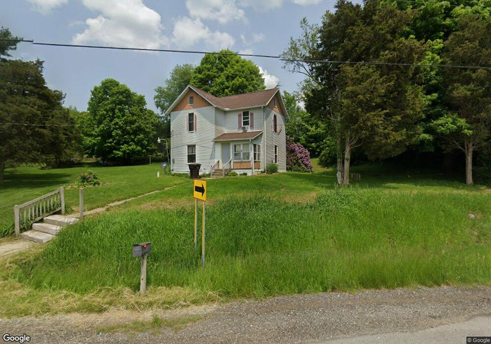
1723 State Route 97 Butler, OH 44822
Estimated Value: $140,626 - $178,000
3
Beds
1
Bath
1,248
Sq Ft
$124/Sq Ft
Est. Value
About This Home
This home is located at 1723 State Route 97, Butler, OH 44822 and is currently estimated at $154,907, approximately $124 per square foot. 1723 State Route 97 is a home located in Richland County with nearby schools including Clear Fork High School.
Ownership History
Date
Name
Owned For
Owner Type
Purchase Details
Closed on
May 25, 2018
Sold by
Kline Sylvia C
Bought by
Kline Rodney N and Kline Dawn M
Current Estimated Value
Purchase Details
Closed on
Jun 19, 2003
Sold by
Estate Of Glen J Shisler
Bought by
Kline Sylvia C
Home Financials for this Owner
Home Financials are based on the most recent Mortgage that was taken out on this home.
Original Mortgage
$57,800
Outstanding Balance
$11,038
Interest Rate
5.71%
Mortgage Type
Unknown
Estimated Equity
$143,869
Create a Home Valuation Report for This Property
The Home Valuation Report is an in-depth analysis detailing your home's value as well as a comparison with similar homes in the area
Home Values in the Area
Average Home Value in this Area
Purchase History
| Date | Buyer | Sale Price | Title Company |
|---|---|---|---|
| Kline Rodney N | -- | None Available | |
| Kline Sylvia C | $68,000 | Chicago Title |
Source: Public Records
Mortgage History
| Date | Status | Borrower | Loan Amount |
|---|---|---|---|
| Open | Kline Sylvia C | $57,800 |
Source: Public Records
Tax History Compared to Growth
Tax History
| Year | Tax Paid | Tax Assessment Tax Assessment Total Assessment is a certain percentage of the fair market value that is determined by local assessors to be the total taxable value of land and additions on the property. | Land | Improvement |
|---|---|---|---|---|
| 2024 | $1,088 | $27,680 | $6,820 | $20,860 |
| 2023 | $1,036 | $27,680 | $6,820 | $20,860 |
| 2022 | $928 | $22,640 | $6,480 | $16,160 |
| 2021 | $1,006 | $22,640 | $6,480 | $16,160 |
| 2020 | $1,006 | $22,640 | $6,480 | $16,160 |
| 2019 | $901 | $19,200 | $5,490 | $13,710 |
| 2018 | $892 | $19,180 | $5,470 | $13,710 |
| 2017 | $877 | $19,180 | $5,470 | $13,710 |
| 2016 | $849 | $18,760 | $5,130 | $13,630 |
| 2015 | $849 | $18,760 | $5,130 | $13,630 |
| 2014 | $847 | $18,760 | $5,130 | $13,630 |
| 2012 | $825 | $18,760 | $5,130 | $13,630 |
Source: Public Records
Map
Nearby Homes
- 3898 Ohio 97
- 128 College St
- 224 Blue Bird Dr
- 5449 Hagerman Rd
- 21625 N Liberty Rd
- 2070 Riggle Rd
- 4169 State Route 97
- 1259 State Route 97 E
- 1260 Ohio 97 Unit 115
- 4978 Bott Rd
- 1169 State Route 97 E
- 5042 Possum Run Rd
- 4234 Swigart Rd
- 0 Mishey Rd
- 85 E Lakeview Dr
- 361 Honey Creek Rd E
- 6533 Durbin Rd
- 0 Kenton Rd
- 6509 Ankneytown Rd
- 6902 Ankneytown Rd
- 1779 State Route 97
- 249 Cleveland St
- 1676 State Route 97
- 1676 Ohio 97
- 1675 State Route 97
- 1801 State Route 97
- 1766 State Route 97
- 1827 State Route 97
- 1827 Ohio 97
- 57 Steven Dr
- 47 Steven Dr
- 0 Wheatcraft Rd
- 19 Steven Dr
- 27 Steven Dr
- 37 Steven Dr
- 26 Steven Dr
- 0 Steven Dr
- 180 Cleveland St
- 180 Cleveland St Unit 168 thru180
- 56 Steven Dr