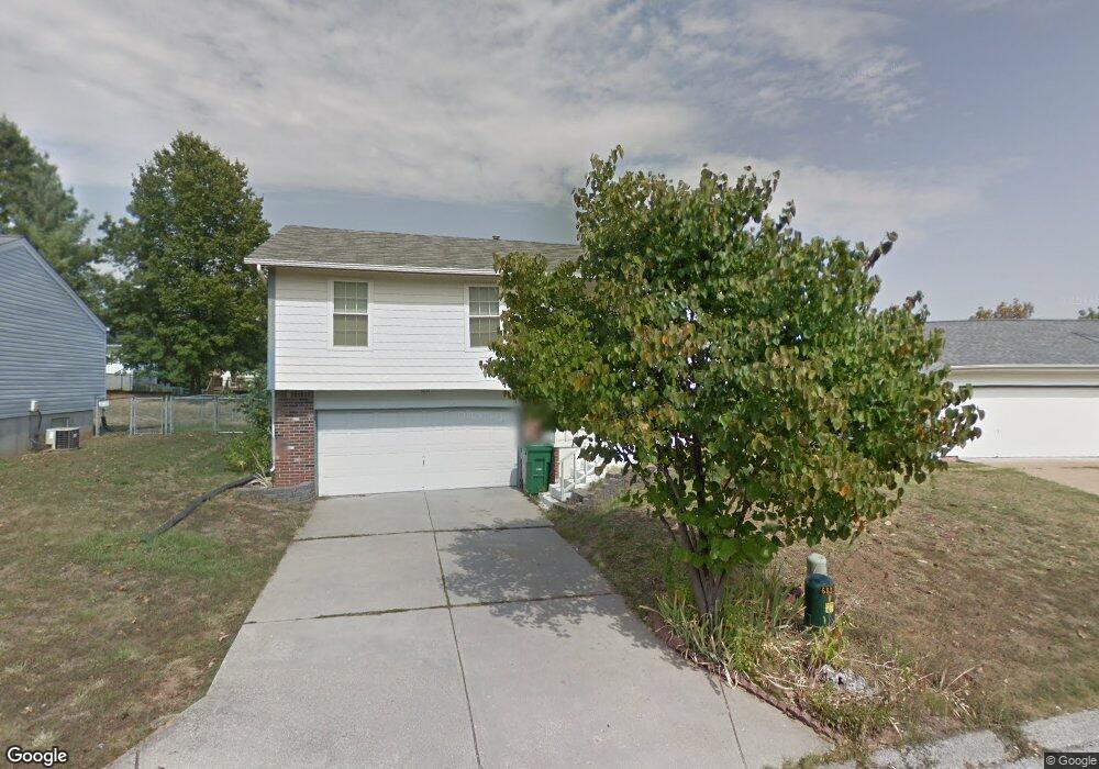
1725 Clark Ln Barnhart, MO 63012
Estimated Value: $220,000 - $241,000
3
Beds
2
Baths
962
Sq Ft
$241/Sq Ft
Est. Value
About This Home
This home is located at 1725 Clark Ln, Barnhart, MO 63012 and is currently estimated at $231,576, approximately $240 per square foot. 1725 Clark Ln is a home located in Jefferson County with nearby schools including Windsor High School and St. Joseph Catholic School.
Ownership History
Date
Name
Owned For
Owner Type
Purchase Details
Closed on
Mar 28, 2009
Sold by
Friedel Jason M and Friedel Carri
Bought by
Allen Theresa R
Current Estimated Value
Home Financials for this Owner
Home Financials are based on the most recent Mortgage that was taken out on this home.
Original Mortgage
$120,344
Interest Rate
4.84%
Mortgage Type
FHA
Purchase Details
Closed on
Sep 7, 2001
Sold by
Mcbride Robert N
Bought by
Friedel Jason M
Home Financials for this Owner
Home Financials are based on the most recent Mortgage that was taken out on this home.
Original Mortgage
$102,885
Interest Rate
6.96%
Mortgage Type
FHA
Purchase Details
Closed on
Oct 27, 2000
Sold by
Holohan Ronald J and Holohan Deenna W
Bought by
Mcbride Robert N and Mcbride Linda C
Home Financials for this Owner
Home Financials are based on the most recent Mortgage that was taken out on this home.
Original Mortgage
$95,212
Interest Rate
7.9%
Mortgage Type
FHA
Create a Home Valuation Report for This Property
The Home Valuation Report is an in-depth analysis detailing your home's value as well as a comparison with similar homes in the area
Home Values in the Area
Average Home Value in this Area
Purchase History
| Date | Buyer | Sale Price | Title Company |
|---|---|---|---|
| Allen Theresa R | -- | Title Partners Agency Llc | |
| Friedel Jason M | -- | Commonwealth Title | |
| Mcbride Robert N | -- | Commonwealth Title |
Source: Public Records
Mortgage History
| Date | Status | Borrower | Loan Amount |
|---|---|---|---|
| Previous Owner | Allen Theresa R | $120,344 | |
| Previous Owner | Friedel Jason M | $102,885 | |
| Previous Owner | Mcbride Robert N | $95,212 |
Source: Public Records
Tax History Compared to Growth
Tax History
| Year | Tax Paid | Tax Assessment Tax Assessment Total Assessment is a certain percentage of the fair market value that is determined by local assessors to be the total taxable value of land and additions on the property. | Land | Improvement |
|---|---|---|---|---|
| 2025 | $1,795 | $27,900 | $5,000 | $22,900 |
| 2024 | $1,795 | $24,500 | $4,000 | $20,500 |
| 2023 | $1,795 | $24,200 | $4,000 | $20,200 |
| 2022 | $1,616 | $22,100 | $1,900 | $20,200 |
| 2021 | $1,617 | $22,100 | $1,900 | $20,200 |
| 2020 | $1,486 | $19,700 | $1,600 | $18,100 |
| 2019 | $1,484 | $19,700 | $1,600 | $18,100 |
| 2018 | $1,464 | $19,700 | $1,600 | $18,100 |
| 2017 | $1,408 | $19,700 | $1,600 | $18,100 |
| 2016 | $1,299 | $18,100 | $1,700 | $16,400 |
| 2015 | $1,295 | $18,100 | $1,700 | $16,400 |
| 2013 | -- | $18,300 | $1,700 | $16,600 |
Source: Public Records
Map
Nearby Homes
- 1728 Fairfax Dr
- 7255 Meriwether Ct
- 7013 Wayles Dr
- 7056 Albermarle Ct
- 7062 Tuckahoe Ct
- 1670 Clover Ct
- 1022 Graystone Park
- 7009 Albermarle Ct
- 7098 Ridge Dr
- 7075 Metropolitan Blvd
- 2090 Birchwood Dr
- 2030 Engle Ridge Rd
- 0 Hwy Mm Unit MAR24032005
- 6788 Haven Hill Rd
- 0 New Highway M Unit MAR25024234
- 1675 Old State Road M
- 6625 Dry Creek Rd
- 0 Highland Terrace
- 6 Huntleigh Woods
- 2000 Lot 10 Crossroads Rd