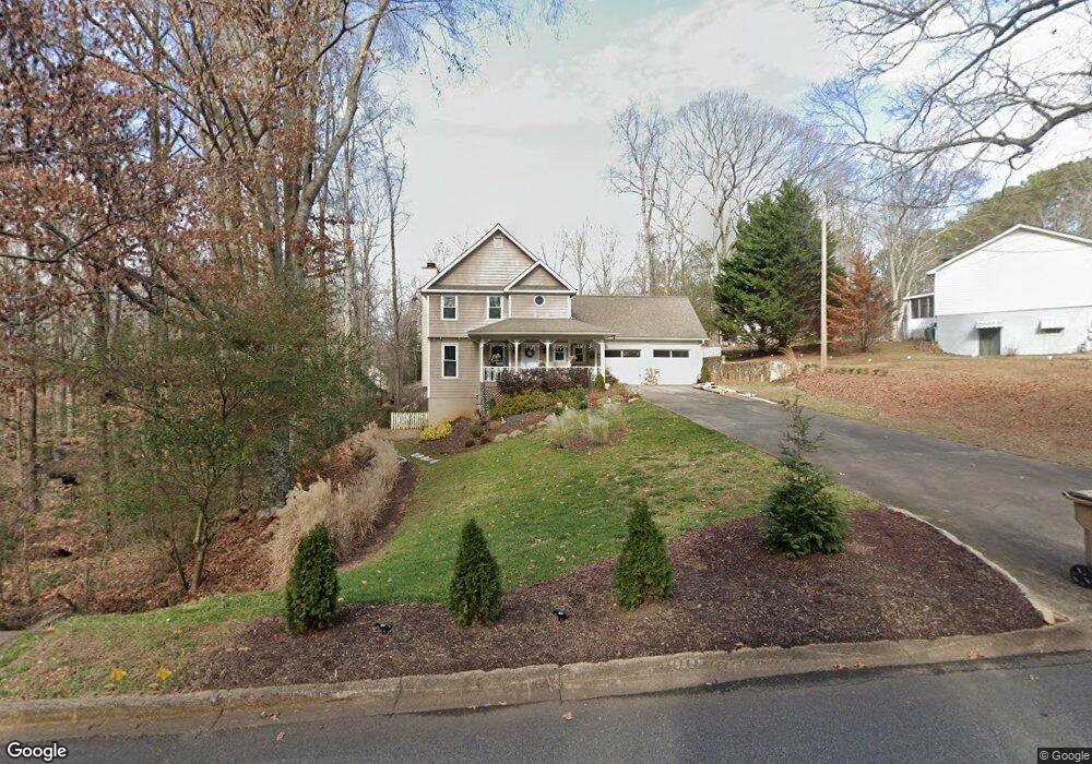
1725 Commonwealth Trail Cumming, GA 30041
Big Creek NeighborhoodEstimated Value: $422,173 - $473,000
3
Beds
3
Baths
1,746
Sq Ft
$255/Sq Ft
Est. Value
About This Home
This home is located at 1725 Commonwealth Trail, Cumming, GA 30041 and is currently estimated at $445,543, approximately $255 per square foot. 1725 Commonwealth Trail is a home located in Forsyth County with nearby schools including Shiloh Point Elementary School, Piney Grove Middle School, and Denmark High School.
Ownership History
Date
Name
Owned For
Owner Type
Purchase Details
Closed on
Dec 29, 2015
Sold by
Mighty Gain Llc
Bought by
Liu Jian
Current Estimated Value
Purchase Details
Closed on
Jul 7, 2015
Sold by
Rbp Llc
Bought by
Mighty Gain Llc
Purchase Details
Closed on
Apr 25, 2005
Sold by
Marchand Walter E and Marchand Belinda
Bought by
Butler Mack D
Home Financials for this Owner
Home Financials are based on the most recent Mortgage that was taken out on this home.
Original Mortgage
$179,500
Interest Rate
6.63%
Mortgage Type
New Conventional
Purchase Details
Closed on
Nov 27, 1996
Sold by
Blankenship Joseph
Bought by
Barchand Walter
Purchase Details
Closed on
Feb 9, 1996
Sold by
Fed Home Loanmtg Corp Shelly
Bought by
Blankenship Joseph
Purchase Details
Closed on
Aug 1, 1995
Sold by
Munda Loy
Bought by
Fed Nat Mtg Corp
Create a Home Valuation Report for This Property
The Home Valuation Report is an in-depth analysis detailing your home's value as well as a comparison with similar homes in the area
Home Values in the Area
Average Home Value in this Area
Purchase History
| Date | Buyer | Sale Price | Title Company |
|---|---|---|---|
| Liu Jian | $190,000 | -- | |
| Mighty Gain Llc | $142,500 | -- | |
| Rbp Llc | $135,000 | -- | |
| Butler Mack D | $179,500 | -- | |
| Barchand Walter | $132,900 | -- | |
| Blankenship Joseph | -- | -- | |
| Fed Nat Mtg Corp | $97,700 | -- |
Source: Public Records
Mortgage History
| Date | Status | Borrower | Loan Amount |
|---|---|---|---|
| Previous Owner | Butler Mack D | $179,500 | |
| Closed | Blankenship Joseph | $0 |
Source: Public Records
Tax History Compared to Growth
Tax History
| Year | Tax Paid | Tax Assessment Tax Assessment Total Assessment is a certain percentage of the fair market value that is determined by local assessors to be the total taxable value of land and additions on the property. | Land | Improvement |
|---|---|---|---|---|
| 2025 | $3,849 | $159,500 | $60,000 | $99,500 |
| 2024 | $3,849 | $156,976 | $60,000 | $96,976 |
| 2023 | $3,649 | $148,248 | $50,000 | $98,248 |
| 2022 | $3,625 | $94,368 | $21,600 | $72,768 |
| 2021 | $2,606 | $94,368 | $21,600 | $72,768 |
| 2020 | $2,523 | $91,360 | $21,600 | $69,760 |
| 2019 | $2,490 | $90,032 | $21,600 | $68,432 |
| 2018 | $1,963 | $70,984 | $18,000 | $52,984 |
| 2017 | $1,752 | $63,144 | $18,000 | $45,144 |
| 2016 | $1,753 | $63,144 | $18,000 | $45,144 |
| 2015 | $1,776 | $63,872 | $18,000 | $45,872 |
| 2014 | $1,594 | $60,224 | $18,000 | $42,224 |
Source: Public Records
Map
Nearby Homes
- 2516 Ballantrae Cir Unit 39
- 1925 Commonwealth Ct
- 2472 Ballantrae Cir Unit 26
- 2530 Ballantrae Cir Unit 45
- 2550 Ballantrae Cir Unit 53
- 2325 S Clement Rd
- 2910 Shoalwood Dr
- Hedgewood with Basement Plan at Willow Glen - Highlands Collection
- Rosalynn Plan at Willow Glen - Reserve Collection
- Rhinewood with Basement Plan at Willow Glen - Reserve Collection
- Montadale with Basement Plan at Willow Glen - Highlands Collection
- Peterson with Basement Plan at Willow Glen - Reserve Collection
- Parkmont Plan at Willow Glen - Reserve Collection
- Parkmont with Basement Plan at Willow Glen - Reserve Collection
- Montadale Plan at Willow Glen - Highlands Collection
- Hillstone Plan at Willow Glen - Highlands Collection
- Peterson Plan at Willow Glen - Reserve Collection
- Antoinette with Basement Plan at Willow Glen - Highlands Collection
- Rosalynn with Basement Plan at Willow Glen - Reserve Collection
- Hillstone with Basement Plan at Willow Glen - Highlands Collection
- 1715 Commonwealth Ave
- 1825 Commonwealth Ln
- 1825 Commonwealth Ln Unit 19
- 1825 Commonwealth Ln
- 1735 Commonwealth Trail
- 1720 Commonwealth Trail
- 1725 Commonwealth Ave
- 1730 Commonwealth Trail
- 1835 Commonwealth Ln
- 1710 Commonwealth Trail
- 1670 Commonwealth Trail
- 1925 Commonwealth Dr
- 1740 Commonwealth Trail
- 1745 Commonwealth Trail
- 1920 Commonwealth Dr
- 1820 Commonwealth Ln
- 1730 Commonwealth Ave
- 1830 Commonwealth Ln
- 2492 Ballantrae Cir Unit 34
- 2496 Ballantrae Cir Unit 35