Estimated Value: $182,559 - $196,000
3
Beds
1
Bath
1,071
Sq Ft
$178/Sq Ft
Est. Value
About This Home
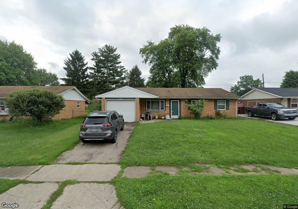
This home is located at 1725 Maumee Dr, Xenia, OH 45385 and is currently estimated at $190,140, approximately $177 per square foot. 1725 Maumee Dr is a home located in Greene County with nearby schools including Xenia High School, Summit Academy Community School for Alternative Learners - Xenia, and Legacy Christian Academy.
Ownership History
Date
Name
Owned For
Owner Type
Purchase Details
Closed on
Oct 27, 2022
Sold by
Bradds Roger and Bradds Connie R
Bought by
Kohen Kelli
Current Estimated Value
Purchase Details
Closed on
Jun 11, 1997
Sold by
Penrod Rodney E
Bought by
Bradds Roger D
Purchase Details
Closed on
Dec 20, 1994
Sold by
Gentner John E
Bought by
Penrod Rodney E and Penrod L
Home Financials for this Owner
Home Financials are based on the most recent Mortgage that was taken out on this home.
Original Mortgage
$67,190
Interest Rate
9.5%
Mortgage Type
VA
Create a Home Valuation Report for This Property
The Home Valuation Report is an in-depth analysis detailing your home's value as well as a comparison with similar homes in the area
Home Values in the Area
Average Home Value in this Area
Purchase History
| Date | Buyer | Sale Price | Title Company |
|---|---|---|---|
| Kohen Kelli | -- | -- | |
| Bradds Roger D | $75,446 | -- | |
| Penrod Rodney E | $65,900 | -- |
Source: Public Records
Mortgage History
| Date | Status | Borrower | Loan Amount |
|---|---|---|---|
| Previous Owner | Penrod Rodney E | $67,190 |
Source: Public Records
Tax History Compared to Growth
Tax History
| Year | Tax Paid | Tax Assessment Tax Assessment Total Assessment is a certain percentage of the fair market value that is determined by local assessors to be the total taxable value of land and additions on the property. | Land | Improvement |
|---|---|---|---|---|
| 2024 | $1,929 | $45,080 | $11,140 | $33,940 |
| 2023 | $1,929 | $45,080 | $11,140 | $33,940 |
| 2022 | $1,598 | $31,860 | $6,550 | $25,310 |
| 2021 | $1,620 | $31,860 | $6,550 | $25,310 |
| 2020 | $1,552 | $31,860 | $6,550 | $25,310 |
| 2019 | $1,221 | $23,590 | $6,370 | $17,220 |
| 2018 | $1,225 | $23,590 | $6,370 | $17,220 |
| 2017 | $1,110 | $23,590 | $6,370 | $17,220 |
| 2016 | $1,110 | $20,970 | $6,370 | $14,600 |
| 2015 | $1,113 | $20,970 | $6,370 | $14,600 |
| 2014 | $1,066 | $20,970 | $6,370 | $14,600 |
Source: Public Records
Map
Nearby Homes
- 1778 Arapaho Dr
- 1403 Texas Dr
- 1618 Navajo Dr
- 1272 Bellbrook Ave
- 1769 Gayhart Dr
- 1653 Seneca Dr
- 1208 Bellbrook Ave
- 1866 Roxbury Dr
- 1829 Gayhart Dr
- 1908 Whitt St
- 1144 Rockwell Dr
- 1568 Cheyenne Dr
- 1255 Colorado Dr
- 1107 Arkansas Dr
- 2758 Wyoming Dr
- 2142 Michigan Dr
- 2257 Maryland Dr
- 161 Montana Dr
- 414 Whisper Ln
- 1342 Kylemore Dr
- 1739 Maumee Dr
- 1713 Maumee Dr
- 1710 Arapaho Dr
- 1751 Maumee Dr
- 1696 Arapaho Dr
- 1699 Maumee Dr
- 1726 Arapaho Dr
- 1728 Maumee Dr
- 1716 Maumee Dr
- 1682 Arapaho Dr
- 1742 Maumee Dr
- 1746 Arapaho Dr
- 1763 Maumee Dr
- 1702 Maumee Dr
- 1754 Maumee Dr
- 1690 Maumee Dr
- 1766 Arapaho Dr
- 1777 Maumee Dr
- 1711 Arapaho Dr
- 1669 Maumee Dr