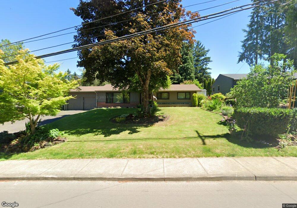
17252 Greentree Ave Lake Oswego, OR 97034
Palisades NeighborhoodEstimated Value: $680,000 - $972,042
3
Beds
2
Baths
1,431
Sq Ft
$559/Sq Ft
Est. Value
About This Home
This home is located at 17252 Greentree Ave, Lake Oswego, OR 97034 and is currently estimated at $800,511, approximately $559 per square foot. 17252 Greentree Ave is a home located in Clackamas County with nearby schools including Hallinan Elementary School, Lakeridge Middle School, and Lakeridge High School.
Ownership History
Date
Name
Owned For
Owner Type
Purchase Details
Closed on
Jun 13, 1995
Sold by
Vial Anne
Bought by
Robb Gregg A and Robb Sally A
Current Estimated Value
Home Financials for this Owner
Home Financials are based on the most recent Mortgage that was taken out on this home.
Original Mortgage
$82,500
Interest Rate
8.36%
Create a Home Valuation Report for This Property
The Home Valuation Report is an in-depth analysis detailing your home's value as well as a comparison with similar homes in the area
Home Values in the Area
Average Home Value in this Area
Purchase History
| Date | Buyer | Sale Price | Title Company |
|---|---|---|---|
| Robb Gregg A | $154,500 | Oregon Title |
Source: Public Records
Mortgage History
| Date | Status | Borrower | Loan Amount |
|---|---|---|---|
| Closed | Robb Gregg A | $82,500 |
Source: Public Records
Tax History Compared to Growth
Tax History
| Year | Tax Paid | Tax Assessment Tax Assessment Total Assessment is a certain percentage of the fair market value that is determined by local assessors to be the total taxable value of land and additions on the property. | Land | Improvement |
|---|---|---|---|---|
| 2025 | $5,227 | $272,177 | -- | -- |
| 2024 | $5,088 | $264,250 | -- | -- |
| 2023 | $5,088 | $256,554 | $0 | $0 |
| 2022 | $4,792 | $249,082 | $0 | $0 |
| 2021 | $4,426 | $241,828 | $0 | $0 |
| 2020 | $4,314 | $234,785 | $0 | $0 |
| 2019 | $4,208 | $227,947 | $0 | $0 |
| 2018 | $4,002 | $221,308 | $0 | $0 |
| 2017 | $3,862 | $214,862 | $0 | $0 |
| 2016 | $3,516 | $208,604 | $0 | $0 |
| 2015 | $3,396 | $202,528 | $0 | $0 |
| 2014 | $3,353 | $196,629 | $0 | $0 |
Source: Public Records
Map
Nearby Homes
- 1951 Greentree Rd
- 1467 Greentree Cir
- 1847 Woodland Terrace
- 1931 Park Forest Ct
- 17958 Saint Clair Dr
- 0 S Shore Blvd
- 2306 Mayors Ln
- 2255 Glen Haven Rd
- 731 Clara Ct
- 1410 Woodland Terrace
- 16878 Canyon Dr
- 1300 Tyndall Ct
- 1224 Tyndall Ct
- 2627 Park Rd
- 1520 Cherry Crest Ave
- 1093 Tyndall Ct
- 17901 Hillside Dr
- 1405 Cherry Crest Ave
- 1015 Southshore Blvd
- 17360 Alpine Way
- 17224 Greentree Ave
- 17326 Greentree Ave
- 17341 Marjorie Ave
- 17217 Marjorie Ave
- 1501 Fernwood Dr
- 17220 Greentree Ave
- 17251 Greentree Ave
- 1625 Fernwood Dr
- 1501 Koawood Dr
- 1550 Fernwood Dr
- 1510 Fernwood Dr
- 1590 Fernwood Dr
- 1620 Fernwood Dr
- 1685 Fernwood Dr
- 17304 Marjorie Ave
- 1660 Mapleleaf Rd
- 0 Marjorie Ave
- 17175 Greentree Ave
- 1491 Koawood Dr