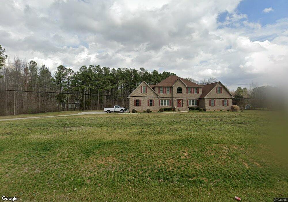
1726 Swepsonville Rd Graham, NC 27253
Estimated Value: $494,000 - $877,485
4
Beds
4
Baths
4,340
Sq Ft
$158/Sq Ft
Est. Value
About This Home
This home is located at 1726 Swepsonville Rd, Graham, NC 27253 and is currently estimated at $685,743, approximately $158 per square foot. 1726 Swepsonville Rd is a home with nearby schools including South Graham Elementary School, Southern Alamance Middle School, and Southern Alamance High School.
Ownership History
Date
Name
Owned For
Owner Type
Purchase Details
Closed on
Apr 30, 2015
Sold by
Goldstien Peggy R
Bought by
Dew Jason S
Current Estimated Value
Home Financials for this Owner
Home Financials are based on the most recent Mortgage that was taken out on this home.
Original Mortgage
$359,600
Outstanding Balance
$278,920
Interest Rate
3.87%
Mortgage Type
New Conventional
Estimated Equity
$406,823
Create a Home Valuation Report for This Property
The Home Valuation Report is an in-depth analysis detailing your home's value as well as a comparison with similar homes in the area
Home Values in the Area
Average Home Value in this Area
Purchase History
| Date | Buyer | Sale Price | Title Company |
|---|---|---|---|
| Dew Jason S | $50,000 | -- |
Source: Public Records
Mortgage History
| Date | Status | Borrower | Loan Amount |
|---|---|---|---|
| Open | Dew Jason S | $359,600 |
Source: Public Records
Tax History Compared to Growth
Tax History
| Year | Tax Paid | Tax Assessment Tax Assessment Total Assessment is a certain percentage of the fair market value that is determined by local assessors to be the total taxable value of land and additions on the property. | Land | Improvement |
|---|---|---|---|---|
| 2025 | $4,006 | $723,122 | $122,602 | $600,520 |
| 2024 | $3,825 | $723,122 | $122,602 | $600,520 |
| 2023 | $3,558 | $723,122 | $122,602 | $600,520 |
| 2022 | $2,921 | $396,723 | $90,912 | $305,811 |
| 2021 | $2,961 | $396,723 | $90,912 | $305,811 |
| 2020 | $3,000 | $396,723 | $90,912 | $305,811 |
| 2019 | $3,015 | $396,723 | $90,912 | $305,811 |
| 2018 | $0 | $396,723 | $90,912 | $305,811 |
| 2017 | $2,658 | $396,723 | $90,912 | $305,811 |
| 2016 | $433 | $64,662 | $64,662 | $0 |
| 2015 | $356 | $53,462 | $53,462 | $0 |
| 2014 | -- | $53,462 | $53,462 | $0 |
Source: Public Records
Map
Nearby Homes
- 2923 Cullens Dr
- 1787 Parham Dr
- 1798 Parham Dr
- 511 Valentine Ct
- 511 Valentine Ct Unit Lot 106
- 1811 Parham Dr
- 1811 Parham Dr Unit 89
- 519 Valentine Ct
- 1819 Parham Dr Unit Lot 87
- 1819 Parham Dr
- 531 Valentine Ct
- 1823 Parham Dr
- 1823 Parham Dr Unit Lot 86
- 535 Valentine Ct
- 535 Valentine Ct Unit Lot 100
- 101 Kingston Ln
- 207 Forest Dr
- 1707 Wedgewood Dr
- Somerset 3 Plan at Valor Ridge
- Cameron Plan at Valor Ridge
- 1738 Swepsonville Rd
- 157 Dixon Rd
- 157 Dixon Rd Unit 1
- 1718 Swepsonville Rd
- 1766 Swepsonville Rd
- 1750 Swepsonville Rd
- 1758 Swepsonville Rd
- 1774 Swepsonville Rd
- 1796 Brier Ln
- 1690 Swepsonville Rd
- 1709 Swepsonville Rd
- 1816 Swepsonville Rd
- 1804 Brier Ln
- 1805 Brier Ln
- 1806 Brier Ln
- 1832 Swepsonville Rd
- 1809 Swepsonville Rd
- 1812 Brier Ln
- 1642 Swepsonville Rd
- 1840 Swepsonville Rd