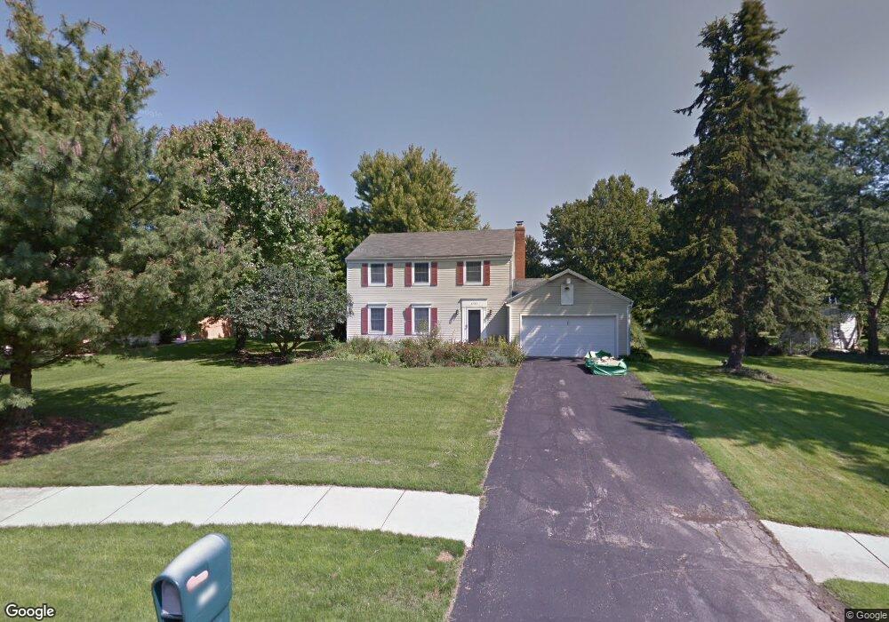
1727 Barlow Rd Hudson, OH 44236
Estimated Value: $342,000 - $396,000
4
Beds
2
Baths
1,792
Sq Ft
$210/Sq Ft
Est. Value
About This Home
This home is located at 1727 Barlow Rd, Hudson, OH 44236 and is currently estimated at $376,530, approximately $210 per square foot. 1727 Barlow Rd is a home located in Summit County with nearby schools including Ellsworth Hill Elementary School, East Woods Intermediate School, and Hudson Middle School.
Ownership History
Date
Name
Owned For
Owner Type
Purchase Details
Closed on
Aug 30, 2004
Sold by
Cross Irene
Bought by
Davis Erik and Davis Stephanie
Current Estimated Value
Home Financials for this Owner
Home Financials are based on the most recent Mortgage that was taken out on this home.
Original Mortgage
$173,375
Outstanding Balance
$87,152
Interest Rate
6.1%
Mortgage Type
Purchase Money Mortgage
Estimated Equity
$289,378
Create a Home Valuation Report for This Property
The Home Valuation Report is an in-depth analysis detailing your home's value as well as a comparison with similar homes in the area
Home Values in the Area
Average Home Value in this Area
Purchase History
| Date | Buyer | Sale Price | Title Company |
|---|---|---|---|
| Davis Erik | $182,500 | Real Living Title Agency Ltd |
Source: Public Records
Mortgage History
| Date | Status | Borrower | Loan Amount |
|---|---|---|---|
| Open | Davis Erik | $173,375 |
Source: Public Records
Tax History Compared to Growth
Tax History
| Year | Tax Paid | Tax Assessment Tax Assessment Total Assessment is a certain percentage of the fair market value that is determined by local assessors to be the total taxable value of land and additions on the property. | Land | Improvement |
|---|---|---|---|---|
| 2025 | $5,797 | $98,158 | $19,485 | $78,673 |
| 2024 | $5,797 | $98,158 | $19,485 | $78,673 |
| 2023 | $5,797 | $98,158 | $19,485 | $78,673 |
| 2022 | $4,368 | $76,091 | $15,103 | $60,988 |
| 2021 | $4,375 | $76,091 | $15,103 | $60,988 |
| 2020 | $4,298 | $76,090 | $15,100 | $60,990 |
| 2019 | $4,187 | $68,580 | $15,100 | $53,480 |
| 2018 | $4,172 | $68,580 | $15,100 | $53,480 |
| 2017 | $4,082 | $68,580 | $15,100 | $53,480 |
| 2016 | $3,603 | $57,020 | $14,350 | $42,670 |
| 2015 | $4,082 | $57,020 | $14,350 | $42,670 |
| 2014 | $3,941 | $57,020 | $14,350 | $42,670 |
| 2013 | $4,217 | $57,020 | $14,350 | $42,670 |
Source: Public Records
Map
Nearby Homes
- 1705 Barlow Rd
- 5791 Sunset Dr
- 5937 Ogilby Dr
- 5974 Anna Lee Dr
- 148 Colony Dr
- 21 Keswick Dr
- 1620 Sapphire Dr
- 5532 Hudson Dr
- 1759 E Sapphire Dr
- 94 Fox Trace Ln
- V/L Norton Rd
- 5139 Rockport Cove
- 1884 Village Ct Unit X66
- V/L Lawnmark Dr
- 35 S Hayden Pkwy
- 1529 Spruce Hill Dr
- 1664 Cypress Ct
- 4891 Cedar Crest Ln
- 4877 Cedar Crest Ln
- 1470 Mac Dr
- 1715 Barlow Rd
- 1739 Barlow Rd
- 5750 Bradford Way
- 5760 Bradford Way
- 5742 Bradford Way
- 1751 Barlow Rd
- 1730 Barlow Rd
- 1706 Barlow Rd
- 5768 Bradford Way
- 5734 Bradford Way
- 1673 Carriage Hill Dr
- 1702 Barlow Rd
- 1695 Barlow Rd
- 1763 Barlow Rd
- 5748 Ogilby Dr
- 5757 Bradford Way
- 1633 Carriage Hill Dr
- 1625 Carriage Hill Dr
- 5774 Bradford Way
- 1694 Barlow Rd