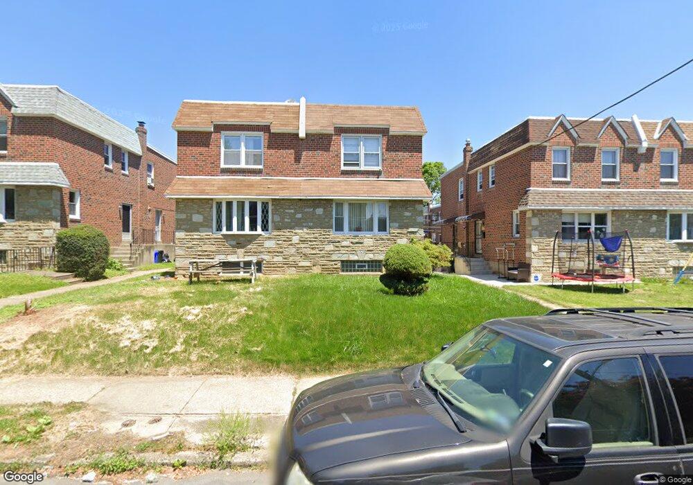
1727 Danforth St Philadelphia, PA 19152
Rhawnhurst NeighborhoodEstimated Value: $292,000 - $319,000
3
Beds
2
Baths
1,236
Sq Ft
$248/Sq Ft
Est. Value
About This Home
This home is located at 1727 Danforth St, Philadelphia, PA 19152 and is currently estimated at $306,612, approximately $248 per square foot. 1727 Danforth St is a home with nearby schools including Farrell Louis H School, Northeast High School, and Tacony Academy Charter School.
Ownership History
Date
Name
Owned For
Owner Type
Purchase Details
Closed on
Jan 27, 2000
Sold by
Berk Mitchell J and Berk Valerie B
Bought by
Edwards Steven L
Current Estimated Value
Home Financials for this Owner
Home Financials are based on the most recent Mortgage that was taken out on this home.
Original Mortgage
$82,900
Outstanding Balance
$25,893
Interest Rate
7.83%
Estimated Equity
$280,719
Create a Home Valuation Report for This Property
The Home Valuation Report is an in-depth analysis detailing your home's value as well as a comparison with similar homes in the area
Home Values in the Area
Average Home Value in this Area
Purchase History
| Date | Buyer | Sale Price | Title Company |
|---|---|---|---|
| Edwards Steven L | $85,500 | First American Title Ins Co |
Source: Public Records
Mortgage History
| Date | Status | Borrower | Loan Amount |
|---|---|---|---|
| Open | Edwards Steven L | $82,900 |
Source: Public Records
Tax History
| Year | Tax Paid | Tax Assessment Tax Assessment Total Assessment is a certain percentage of the fair market value that is determined by local assessors to be the total taxable value of land and additions on the property. | Land | Improvement |
|---|---|---|---|---|
| 2026 | $3,270 | $292,600 | $58,520 | $234,080 |
| 2025 | $3,270 | $292,600 | $58,520 | $234,080 |
| 2024 | $3,270 | $292,600 | $58,520 | $234,080 |
| 2023 | $3,270 | $233,600 | $46,720 | $186,880 |
| 2022 | $2,076 | $188,600 | $46,720 | $141,880 |
| 2021 | $2,706 | $0 | $0 | $0 |
| 2020 | $2,706 | $0 | $0 | $0 |
| 2019 | $2,464 | $0 | $0 | $0 |
| 2018 | $2,308 | $0 | $0 | $0 |
| 2017 | $2,308 | $0 | $0 | $0 |
Source: Public Records
Map
Nearby Homes
- 1701 Bergen St
- 1821 Kendrick St
- 1812 Kendrick St
- 1827 Arnold St
- 1804 Mower St
- 1629 Strahle St
- 1826 Fox Chase Rd
- 8513 Bustleton Ave
- 1734 Strahle St
- 1605 Strahle St
- 1608 Strahle St
- 1621 Benson St
- 1804 Hoffnagle St
- 8557 Castor Ave
- 2034 Bergen St
- 8572 Benton Ave
- 1810 Stanwood St
- 2201 Strahle St Unit C302
- 2201 00 Strahle St Unit D3
- 2201 00 Strahle St Unit B207
- 1725 Danforth St
- 1729 Danforth St
- 1731 Danforth St
- 1723 Danforth St
- 1733 Danforth St
- 1721 Danforth St
- 1724 Megargee St
- 1726 Megargee St
- 1735 Danforth St
- 1722 Megargee St
- 1728 Megargee St
- 1720 Megargee St
- 1719 Danforth St
- 1730 Megargee St
- 1717 Danforth St Unit BASEMENT ONLY
- 1717 Danforth St Unit 1ST FLOOR
- 1717 Danforth St
- 1718 Megargee St
- 1737 Danforth St
- 1726 Danforth St
Your Personal Tour Guide
Ask me questions while you tour the home.