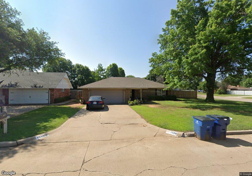
1728 Brookline Dr Duncan, OK 73533
Estimated Value: $162,000 - $185,000
3
Beds
2
Baths
1,644
Sq Ft
$103/Sq Ft
Est. Value
About This Home
This home is located at 1728 Brookline Dr, Duncan, OK 73533 and is currently estimated at $168,845, approximately $102 per square foot. 1728 Brookline Dr is a home located in Stephens County with nearby schools including Horace Mann Elementary School, Duncan Middle School, and Duncan High School.
Ownership History
Date
Name
Owned For
Owner Type
Purchase Details
Closed on
Apr 27, 2015
Sold by
Chronister Charles E and Chronister Charlotte A
Bought by
Spurlock James Tiny and Spurlock Shiela Rae
Current Estimated Value
Purchase Details
Closed on
Apr 15, 2002
Sold by
V A
Bought by
Chronister Charles E
Purchase Details
Closed on
Oct 16, 2001
Sold by
Samuels Billy and Samuels Randie
Purchase Details
Closed on
Sep 25, 1998
Sold by
Price Kord R
Purchase Details
Closed on
Jul 28, 1997
Sold by
Shankles John E
Create a Home Valuation Report for This Property
The Home Valuation Report is an in-depth analysis detailing your home's value as well as a comparison with similar homes in the area
Home Values in the Area
Average Home Value in this Area
Purchase History
| Date | Buyer | Sale Price | Title Company |
|---|---|---|---|
| Spurlock James Tiny | $98,000 | None Available | |
| Chronister Charles E | -- | -- | |
| -- | -- | -- | |
| -- | $79,000 | -- | |
| -- | $60,000 | -- |
Source: Public Records
Tax History Compared to Growth
Tax History
| Year | Tax Paid | Tax Assessment Tax Assessment Total Assessment is a certain percentage of the fair market value that is determined by local assessors to be the total taxable value of land and additions on the property. | Land | Improvement |
|---|---|---|---|---|
| 2025 | $1,178 | $13,309 | $1,046 | $12,263 |
| 2024 | $1,178 | $13,825 | $1,046 | $12,779 |
| 2023 | $1,178 | $13,167 | $1,046 | $12,121 |
| 2022 | $1,117 | $13,399 | $1,046 | $12,353 |
| 2021 | $1,065 | $12,512 | $1,046 | $11,466 |
| 2020 | $1,046 | $12,113 | $1,046 | $11,067 |
| 2019 | $998 | $11,536 | $1,046 | $10,490 |
| 2018 | $979 | $11,170 | $1,046 | $10,124 |
| 2017 | $899 | $10,464 | $1,046 | $9,418 |
| 2016 | $926 | $10,897 | $1,046 | $9,851 |
| 2015 | $935 | $11,438 | $1,046 | $10,392 |
| 2014 | $935 | $11,438 | $1,046 | $10,392 |
Source: Public Records
Map
Nearby Homes
- 1829 1829 Terrace Dr
- 1706 Windsor Dr
- 2360 Rockwell Dr
- 2321 Rockwell Dr
- 2403 Meadow View Dr
- 2120 2120 Flamingo Ln
- 1927 High Meadow Dr
- 2202 W Canary Ave
- 1601 1601 Pearl
- 1404 1404 Ne Aspen
- 1311 1311 N 20 St
- 1405 Evergreen Dr
- 1527 1527 N 13th
- 2108 W Club Rd
- 2110 W Club Rd
- 2201 W Club Rd
- 1302 N 21st St
- 3990 N Ridgeview Dr
- 1402 1402 W Elk Ave
- 1212 1212 N 21st
- 1730 Brookline Dr
- 1722 Overland Dr
- 1726 Brookline Dr
- 1732 Brookline Dr
- 1729 Brookline Dr
- 1720 Overland Dr
- 1721 Wilshire Dr
- 1731 Brookline Dr
- 1731 1731 Brookline
- 1719 Wilshire Dr
- 1719 Overland Dr
- 1727 Brookline Dr
- 1724 Brookline Dr
- 1734 Brookline Dr
- 1718 Overland Dr
- 1733 Brookline Dr
- 1717 Wilshire Dr
- 1804 Overland Dr
- 1725 Brookline Dr
- 1717 Overland Dr