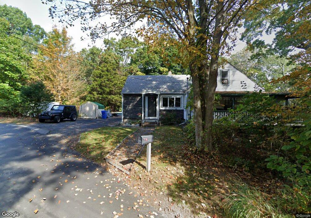
173 Depot Rd Uncasville, CT 06382
Oxoboxo River NeighborhoodEstimated Value: $140,000 - $328,000
3
Beds
2
Baths
1,368
Sq Ft
$200/Sq Ft
Est. Value
About This Home
This home is located at 173 Depot Rd, Uncasville, CT 06382 and is currently estimated at $273,579, approximately $199 per square foot. 173 Depot Rd is a home located in New London County with nearby schools including Leonard J. Tyl Middle School, Montville High School, and Bradley School-New London Regional.
Ownership History
Date
Name
Owned For
Owner Type
Purchase Details
Closed on
Dec 20, 2021
Sold by
Stauffer Hayes R
Bought by
Stauffer-Johnson Joanne J
Current Estimated Value
Purchase Details
Closed on
Sep 14, 2021
Sold by
Stanley Rose M
Bought by
Stauffer Hayes R and Johnson Joanne J
Purchase Details
Closed on
May 15, 2015
Sold by
Levine Barry
Bought by
Beebe Todd
Purchase Details
Closed on
Feb 3, 2015
Sold by
Wells Fargo Bank Na
Bought by
Levine Barry
Create a Home Valuation Report for This Property
The Home Valuation Report is an in-depth analysis detailing your home's value as well as a comparison with similar homes in the area
Home Values in the Area
Average Home Value in this Area
Purchase History
| Date | Buyer | Sale Price | Title Company |
|---|---|---|---|
| Stauffer-Johnson Joanne J | -- | None Available | |
| Stauffer-Johnson Joanne J | -- | None Available | |
| Stauffer Hayes R | $30,000 | None Available | |
| Stauffer Hayes R | $30,000 | None Available | |
| Beebe Todd | $28,000 | -- | |
| Beebe Todd | $28,000 | -- | |
| Levine Barry | $15,000 | -- | |
| Levine Barry | $15,000 | -- |
Source: Public Records
Tax History Compared to Growth
Tax History
| Year | Tax Paid | Tax Assessment Tax Assessment Total Assessment is a certain percentage of the fair market value that is determined by local assessors to be the total taxable value of land and additions on the property. | Land | Improvement |
|---|---|---|---|---|
| 2025 | $3,302 | $114,380 | $30,870 | $83,510 |
| 2024 | $3,176 | $114,380 | $30,870 | $83,510 |
| 2023 | $3,176 | $114,380 | $30,870 | $83,510 |
| 2022 | $3,055 | $114,380 | $30,870 | $83,510 |
| 2021 | $2,994 | $94,290 | $29,850 | $64,440 |
| 2020 | $3,053 | $94,290 | $29,850 | $64,440 |
| 2019 | $3,065 | $94,290 | $29,850 | $64,440 |
| 2018 | $2,992 | $94,290 | $29,850 | $64,440 |
| 2017 | $2,989 | $94,290 | $29,850 | $64,440 |
| 2016 | $2,993 | $97,780 | $37,450 | $60,330 |
| 2015 | $2,993 | $97,840 | $37,510 | $60,330 |
| 2014 | $2,874 | $97,840 | $37,510 | $60,330 |
Source: Public Records
Map
Nearby Homes
- 36 Depot Rd
- 13 Dock Rd
- 184 Kitemaug Rd
- 6 Sunset Rd
- 245 Norwich New London Turnpike Unit 22
- 197 Norwich-New London Turnpike
- 9 West Dr
- 421 Kitemaug Rd
- 10 Crestview Dr
- 60 Hammel Ln
- 127 Massapeag Rd
- 170 Raymond Hill Rd
- 10 Riched Ln
- 0 Clarks Falls Unit 24089817
- 1465 Norwich-New London Turnpike
- 57 Roselund Hill Rd
- 31 Richard Rd
- 18 Richard Rd
- 5 Ledgewood Dr
- 19 Wyndwood Rd