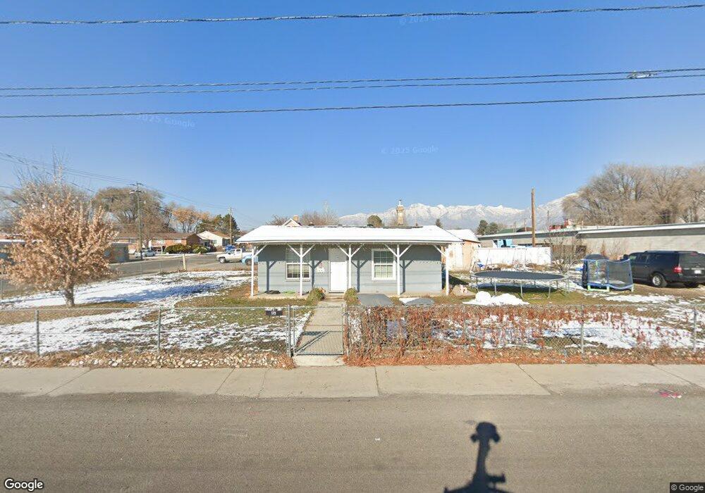
173 E 100 N American Fork, UT 84003
Estimated Value: $376,000 - $405,000
3
Beds
1
Bath
1,150
Sq Ft
$344/Sq Ft
Est. Value
About This Home
This home is located at 173 E 100 N, American Fork, UT 84003 and is currently estimated at $395,495, approximately $343 per square foot. 173 E 100 N is a home located in Utah County with nearby schools including Forbes Elementary School, American Fork Junior High School, and American Fork High School.
Ownership History
Date
Name
Owned For
Owner Type
Purchase Details
Closed on
Oct 28, 2024
Sold by
Redford T Jeffrey and Clearwing Lc
Bought by
Saver Storage Af Llc
Current Estimated Value
Purchase Details
Closed on
Aug 13, 2008
Sold by
Jensen Phil D and Jensen Ruth H
Bought by
Jedco Lc
Home Financials for this Owner
Home Financials are based on the most recent Mortgage that was taken out on this home.
Original Mortgage
$59,214
Interest Rate
6.27%
Mortgage Type
Purchase Money Mortgage
Create a Home Valuation Report for This Property
The Home Valuation Report is an in-depth analysis detailing your home's value as well as a comparison with similar homes in the area
Home Values in the Area
Average Home Value in this Area
Purchase History
Date | Buyer | Sale Price | Title Company |
---|---|---|---|
Saver Storage Af Llc | -- | Meridian Title | |
Clearwing Lc | -- | Meridian Title | |
Jedco Lc | -- | Meridian Title Company Lehi |
Source: Public Records
Mortgage History
Date | Status | Borrower | Loan Amount |
---|---|---|---|
Previous Owner | Alpha Self Storage Lc | $1,000,000 | |
Previous Owner | Jedco Lc | $59,214 |
Source: Public Records
Tax History Compared to Growth
Tax History
Year | Tax Paid | Tax Assessment Tax Assessment Total Assessment is a certain percentage of the fair market value that is determined by local assessors to be the total taxable value of land and additions on the property. | Land | Improvement |
---|---|---|---|---|
2024 | $1,499 | $166,595 | $0 | $0 |
2023 | $1,386 | $163,240 | $0 | $0 |
2022 | $1,508 | $175,340 | $0 | $0 |
2021 | $1,279 | $232,300 | $140,300 | $92,000 |
2020 | $1,191 | $209,700 | $125,300 | $84,400 |
2019 | $1,029 | $187,400 | $107,400 | $80,000 |
2018 | $954 | $166,200 | $96,600 | $69,600 |
2017 | $899 | $84,480 | $0 | $0 |
2016 | $839 | $73,260 | $0 | $0 |
2015 | $847 | $70,235 | $0 | $0 |
2014 | $835 | $68,255 | $0 | $0 |
Source: Public Records
Map
Nearby Homes
- 148 N 100 E
- 196 N 100 E
- 186 E State St Unit 963
- 106 E State St Unit 954
- 192 E State St Unit 964
- 198 E State St Unit 965
- 208 E State St Unit 967
- 57 W 200 N
- 371 E Empire Dr Unit 150
- 105 N 100 W
- 129 W Pacific Dr
- 188 N 150 W
- 444 N 100 E
- 154 S 400 E
- 196 S Center St
- 145 E 500 N
- 494 N 300 E
- 573 E Main St Unit 11
- 240 Robinson Ave
- 335 N 200 W