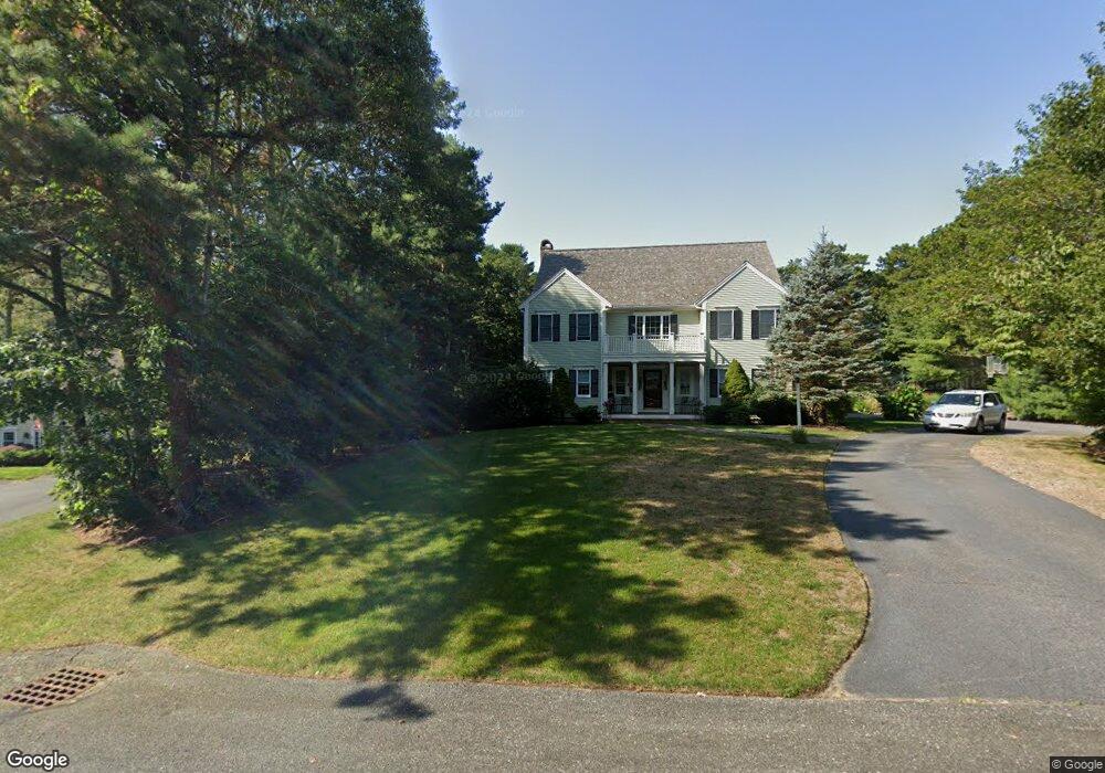
173 Whitmar Rd Cotuit, MA 02635
Cotuit NeighborhoodEstimated Value: $1,257,000 - $1,372,000
4
Beds
5
Baths
3,740
Sq Ft
$350/Sq Ft
Est. Value
About This Home
This home is located at 173 Whitmar Rd, Cotuit, MA 02635 and is currently estimated at $1,310,745, approximately $350 per square foot. 173 Whitmar Rd is a home located in Barnstable County with nearby schools including West Villages Elementary School, Barnstable United Elementary School, and Barnstable Intermediate School.
Ownership History
Date
Name
Owned For
Owner Type
Purchase Details
Closed on
Apr 27, 2017
Sold by
Edwards Diane M and Edwards Edwin B
Bought by
Edwards T 2017
Current Estimated Value
Purchase Details
Closed on
Mar 9, 1992
Sold by
Callahan John R
Bought by
Edwards Edwin B
Create a Home Valuation Report for This Property
The Home Valuation Report is an in-depth analysis detailing your home's value as well as a comparison with similar homes in the area
Home Values in the Area
Average Home Value in this Area
Purchase History
| Date | Buyer | Sale Price | Title Company |
|---|---|---|---|
| Edwards T 2017 | -- | -- | |
| Edwards Edwin B | $75,000 | -- |
Source: Public Records
Mortgage History
| Date | Status | Borrower | Loan Amount |
|---|---|---|---|
| Previous Owner | Edwards Edwin B | $250,000 | |
| Previous Owner | Edwards Edwin B | $300,000 |
Source: Public Records
Tax History
| Year | Tax Paid | Tax Assessment Tax Assessment Total Assessment is a certain percentage of the fair market value that is determined by local assessors to be the total taxable value of land and additions on the property. | Land | Improvement |
|---|---|---|---|---|
| 2025 | $9,392 | $1,124,800 | $202,800 | $922,000 |
| 2024 | $8,449 | $1,072,200 | $202,800 | $869,400 |
| 2023 | $7,899 | $943,700 | $200,400 | $743,300 |
| 2022 | $7,848 | $759,000 | $142,500 | $616,500 |
| 2021 | $7,759 | $702,700 | $142,500 | $560,200 |
| 2020 | $7,660 | $654,100 | $142,500 | $511,600 |
| 2019 | $7,775 | $654,500 | $142,500 | $512,000 |
| 2018 | $3,076 | $602,600 | $156,300 | $446,300 |
| 2017 | $6,955 | $589,400 | $156,300 | $433,100 |
| 2016 | $6,784 | $589,400 | $156,300 | $433,100 |
| 2015 | $6,439 | $558,900 | $155,000 | $403,900 |
Source: Public Records
Map
Nearby Homes
- 602 Putnam Ave
- 1415 Old Post Rd
- 15 Geraldine Rd
- 165 Baxter Neck Rd
- 564 Cotuit Bay Dr
- 564 Cotuit Bay Dr
- 835 Old Post Rd
- 359 Baxter Neck Rd
- 1456 Santuit-Newtown Rd
- 68 Hilltop Dr
- 71 Sand Point
- 280 Ice Valley Rd
- 75 Bob White Run
- 78 Brittany Dr
- 135 Putnam Avenue (Land)
- 804 Main St
- 25 Oyster Way
- 98 Bunker Hill Rd
- 226 Dunrobin Rd
- 152 Wakeby Rd
- 187 Whitmar Rd
- 151 Whitmar Rd
- 172 Whitmar Rd
- 186 Whitmar Rd
- 156 Whitmar Rd
- 143 Whitmar Rd
- 18 Cornwall Ct
- 5 Crystal Ridge Rd
- 6 Cornwall Ct
- 129 Whitmar Rd
- 136 Whitmar Rd
- 11 Cornwall Ct
- 21 Crystal Ridge Rd
- 228 Cotuit Bay Dr
- 37 Crystal Ridge Rd
- 122 Whitmar Rd
- 113 Whitmar Rd
- 55 Crystal Ridge Rd
- 6 Crystal Ridge Rd
- 214 Cotuit Bay Dr
Your Personal Tour Guide
Ask me questions while you tour the home.