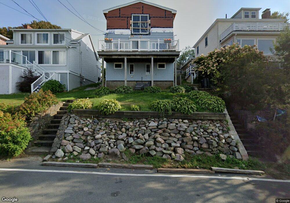
173 Wilson Rd Nahant, MA 01908
Estimated Value: $854,000 - $1,018,000
2
Beds
3
Baths
1,691
Sq Ft
$542/Sq Ft
Est. Value
About This Home
This home is located at 173 Wilson Rd, Nahant, MA 01908 and is currently estimated at $915,924, approximately $541 per square foot. 173 Wilson Rd is a home located in Essex County with nearby schools including Johnson Elementary School, Swampscott Middle School, and Swampscott High School.
Ownership History
Date
Name
Owned For
Owner Type
Purchase Details
Closed on
Jun 23, 2006
Sold by
Porcaro Diane M and Zampanti Joseph
Bought by
Schena Michael S and Schena Roxanne M
Current Estimated Value
Purchase Details
Closed on
Sep 14, 2005
Sold by
Brennan Jean M and Bagley Richard A
Bought by
Porcaro Diane M and Zampanti Joseph
Home Financials for this Owner
Home Financials are based on the most recent Mortgage that was taken out on this home.
Original Mortgage
$336,000
Interest Rate
5.84%
Mortgage Type
Purchase Money Mortgage
Create a Home Valuation Report for This Property
The Home Valuation Report is an in-depth analysis detailing your home's value as well as a comparison with similar homes in the area
Home Values in the Area
Average Home Value in this Area
Purchase History
| Date | Buyer | Sale Price | Title Company |
|---|---|---|---|
| Schena Michael S | $480,000 | -- | |
| Schena Michael S | $480,000 | -- | |
| Porcaro Diane M | $420,000 | -- | |
| Porcaro Diane M | $420,000 | -- | |
| Porcaro Diane M | $420,000 | -- |
Source: Public Records
Mortgage History
| Date | Status | Borrower | Loan Amount |
|---|---|---|---|
| Previous Owner | Porcaro Diane M | $336,000 |
Source: Public Records
Tax History
| Year | Tax Paid | Tax Assessment Tax Assessment Total Assessment is a certain percentage of the fair market value that is determined by local assessors to be the total taxable value of land and additions on the property. | Land | Improvement |
|---|---|---|---|---|
| 2025 | $7,441 | $813,200 | $502,200 | $311,000 |
| 2024 | $7,201 | $793,900 | $482,900 | $311,000 |
| 2023 | $6,374 | $701,200 | $424,900 | $276,300 |
| 2022 | $6,129 | $626,000 | $367,000 | $259,000 |
| 2021 | $5,991 | $570,000 | $328,300 | $241,700 |
| 2020 | $5,633 | $513,500 | $328,300 | $185,200 |
| 2019 | $4,739 | $434,400 | $289,700 | $144,700 |
| 2018 | $4,453 | $434,400 | $289,700 | $144,700 |
| 2017 | $4,548 | $434,400 | $289,700 | $144,700 |
| 2016 | $4,404 | $418,600 | $280,100 | $138,500 |
| 2015 | $3,990 | $365,400 | $226,900 | $138,500 |
| 2014 | $4,030 | $365,400 | $226,900 | $138,500 |
Source: Public Records
Map
Nearby Homes
- 9 Little Nahant Rd
- 66 Ocean St
- 1 Goddard Dr
- 183 Bass Point Rd
- 162 Willow Rd Unit 11
- 51 Cliff St
- 9 Beach Rd Unit 4
- 98 Lynnway
- 12 Chancery Ct Unit 404
- 107 Lynnway
- 154 Lynnway Unit 520
- 154 Lynnway Unit 205
- 300 Lynn Shore Dr Unit 711
- 285 Lynn Shore Dr Unit 308
- 285 Lynn Shore Dr Unit 508
- 285 Lynn Shore Dr Unit 203
- 95 Nahant St Unit 12
- 95 Nahant St Unit 5-33
- 66 Sagamore St
- 25 W Baltimore St
- 175 Wilson Rd
- 171 Wilson Rd
- 179 Wilson Rd
- 78B Lennox Rd Unit 78B
- 78 Lennox Rd Unit 80
- 78 Lennox Rd Unit 80
- 78 Lennox Rd Unit 80
- 78 Lennox Rd Unit 80
- 78 Lennox Rd Unit B
- 78 Lennox Rd Unit B
- 78B Lennox Rd Unit 3 B
- 78 Lennox Rd Unit 3
- 169 Wilson Rd
- 182 Wilson Rd
- 200 Wilson Rd Unit 3
- 200 Wilson Rd Unit 2
- 200 Wilson Rd Unit 1
- 200 Wilson Rd Unit ONE
- 176 Wilson Rd
- 84 Lennox Rd