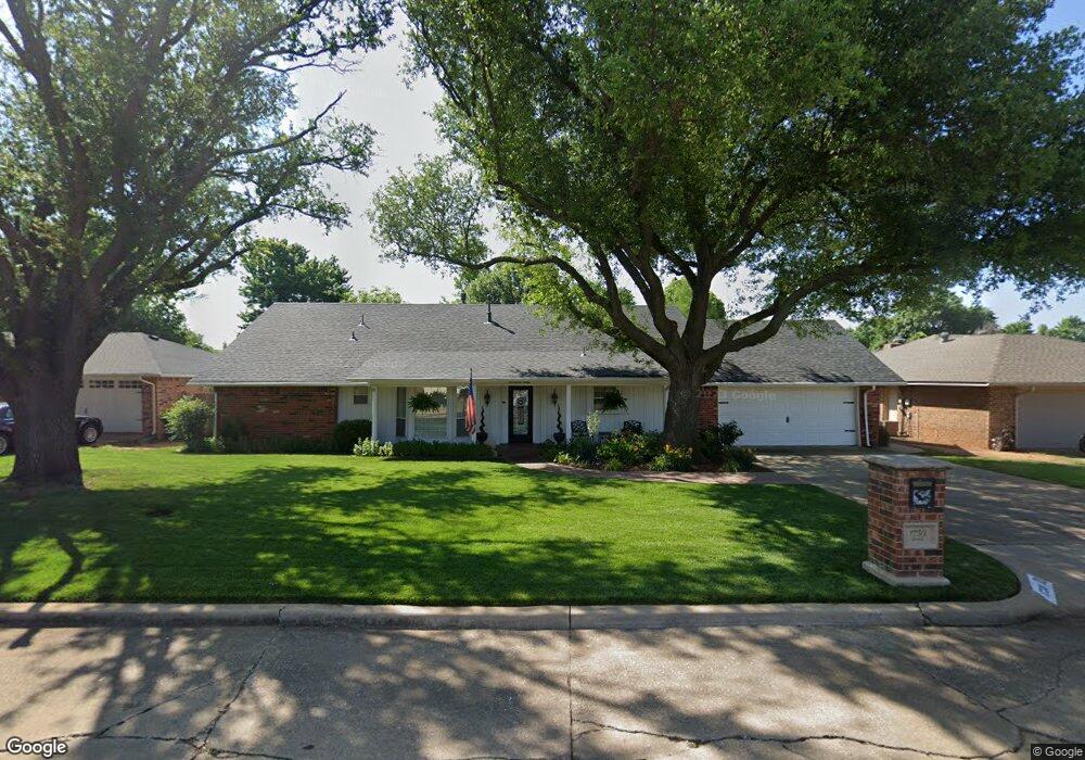
1730 Brookline Dr Duncan, OK 73533
Estimated Value: $165,494 - $190,000
3
Beds
2
Baths
1,637
Sq Ft
$110/Sq Ft
Est. Value
About This Home
This home is located at 1730 Brookline Dr, Duncan, OK 73533 and is currently estimated at $180,874, approximately $110 per square foot. 1730 Brookline Dr is a home located in Stephens County with nearby schools including Horace Mann Elementary School, Duncan Middle School, and Duncan High School.
Ownership History
Date
Name
Owned For
Owner Type
Purchase Details
Closed on
Dec 7, 2011
Sold by
Amerson Sammye W and Amerson Deborah A
Bought by
Amerson Sammye Wayne and Amerson Deborah Ann
Current Estimated Value
Purchase Details
Closed on
Dec 5, 2011
Sold by
Amerson Sammye Wayne and Amerson Deborah Ann
Bought by
Amerson Sammye W and Amerson Deborah A
Purchase Details
Closed on
Dec 13, 2007
Sold by
Amerson Sammye Wayne and Amerson Sammye W
Bought by
Amerson Sammye Wayne and Amerson Deborah Ann
Purchase Details
Closed on
Jun 15, 1990
Create a Home Valuation Report for This Property
The Home Valuation Report is an in-depth analysis detailing your home's value as well as a comparison with similar homes in the area
Purchase History
| Date | Buyer | Sale Price | Title Company |
|---|---|---|---|
| Amerson Sammye Wayne | -- | None Available | |
| Amerson Sammye W | -- | None Available | |
| Amerson Sammye Wayne | -- | None Available | |
| -- | $3,500 | -- |
Source: Public Records
Tax History
| Year | Tax Paid | Tax Assessment Tax Assessment Total Assessment is a certain percentage of the fair market value that is determined by local assessors to be the total taxable value of land and additions on the property. | Land | Improvement |
|---|---|---|---|---|
| 2025 | $1,182 | $15,014 | $978 | $14,036 |
| 2024 | $1,120 | $14,153 | $978 | $13,175 |
| 2023 | $1,120 | $14,152 | $978 | $13,174 |
| 2022 | $1,049 | $13,740 | $978 | $12,762 |
| 2021 | $1,017 | $12,952 | $978 | $11,974 |
| 2020 | $1,034 | $12,972 | $978 | $11,994 |
| 2019 | $1,003 | $12,594 | $978 | $11,616 |
| 2018 | $1,043 | $12,957 | $978 | $11,979 |
| 2017 | $974 | $12,336 | $978 | $11,358 |
| 2016 | $954 | $12,221 | $978 | $11,243 |
| 2015 | $863 | $11,865 | $978 | $10,887 |
| 2014 | $863 | $11,519 | $978 | $10,541 |
Source: Public Records
Map
Nearby Homes
- 1713 Wilshire Dr
- 1923 Windsor Dr
- 1829 Terrace Dr
- 2318 Rockwell Dr
- 2330 Rockwell Dr
- 2346 Rockwell Dr
- Monroe Plan at Wilkinson
- Jefferson Plan at Wilkinson
- Roosevelt Plan at Wilkinson
- 2345 Rockwell Dr
- 2363 Rockwell Dr
- 2375 Rockwell Dr
- 2021 Overland Dr
- 2024 N Woodrock Dr
- 2387 Rockwell Dr
- 2129 W Mallard Dr
- 2360 Rockwell Dr
- 2333 Rockwell Dr
- 2321 Rockwell Dr
- 2310 Rockwell Dr
- 1732 Brookline Dr
- 1728 Brookline Dr
- 1722 Overland Dr
- 1721 Wilshire Dr
- 1734 Brookline Dr
- 1731 Brookline Dr
- 1731 1731 Brookline
- 1729 Brookline Dr
- 1719 Wilshire Dr
- 1733 Brookline Dr
- 1720 Overland Dr
- 1726 Brookline Dr
- 1717 Wilshire Dr
- 1735 Brookline Dr
- 1722 Wilshire Dr
- 1804 Overland Dr
- 1727 Brookline Dr
- 1718 Overland Dr
- 1719 Overland Dr
- 1720 Wilshire Dr
Your Personal Tour Guide
Ask me questions while you tour the home.