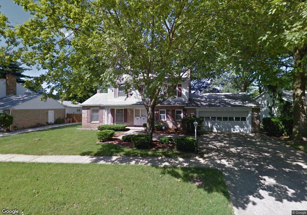
1730 Lynbrook Dr Flint, MI 48507
Westgate NeighborhoodEstimated Value: $185,000 - $211,636
4
Beds
3
Baths
2,110
Sq Ft
$91/Sq Ft
Est. Value
About This Home
This home is located at 1730 Lynbrook Dr, Flint, MI 48507 and is currently estimated at $192,909, approximately $91 per square foot. 1730 Lynbrook Dr is a home located in Genesee County with nearby schools including Neithercut Elementary School, Flint Southwestern Classical Academy, and International Academy of Flint (K-12).
Ownership History
Date
Name
Owned For
Owner Type
Purchase Details
Closed on
Jul 29, 2025
Sold by
Boyd Ester G
Bought by
Boyd Ester G and Ward Ronald K
Current Estimated Value
Purchase Details
Closed on
Jan 11, 2018
Sold by
Pegues Joe L and Pegues Joanne
Bought by
Boyd Ester G
Purchase Details
Closed on
May 25, 2011
Sold by
Citimortgage Inc
Bought by
Pegues Joe L
Purchase Details
Closed on
Jun 16, 2010
Sold by
Wright Stanley
Bought by
Citimortgage Inc
Purchase Details
Closed on
Oct 31, 2006
Sold by
Ross Dorsey and Ross Carla N
Bought by
Wright Stanley
Home Financials for this Owner
Home Financials are based on the most recent Mortgage that was taken out on this home.
Original Mortgage
$126,400
Interest Rate
8.59%
Mortgage Type
Purchase Money Mortgage
Create a Home Valuation Report for This Property
The Home Valuation Report is an in-depth analysis detailing your home's value as well as a comparison with similar homes in the area
Home Values in the Area
Average Home Value in this Area
Purchase History
| Date | Buyer | Sale Price | Title Company |
|---|---|---|---|
| Boyd Ester G | -- | None Listed On Document | |
| Boyd Ester G | -- | None Available | |
| Pegues Joe L | $38,025 | Etitle Agency Inc | |
| Citimortgage Inc | $15,643 | None Available | |
| Wright Stanley | $158,000 | Cislo Title Co |
Source: Public Records
Mortgage History
| Date | Status | Borrower | Loan Amount |
|---|---|---|---|
| Previous Owner | Wright Stanley | $126,400 |
Source: Public Records
Tax History Compared to Growth
Tax History
| Year | Tax Paid | Tax Assessment Tax Assessment Total Assessment is a certain percentage of the fair market value that is determined by local assessors to be the total taxable value of land and additions on the property. | Land | Improvement |
|---|---|---|---|---|
| 2025 | $3,823 | $96,600 | $0 | $0 |
| 2024 | $3,482 | $93,700 | $0 | $0 |
| 2023 | $3,354 | $75,500 | $0 | $0 |
| 2022 | $0 | $64,700 | $0 | $0 |
| 2021 | $3,430 | $55,300 | $0 | $0 |
| 2020 | $3,092 | $43,900 | $0 | $0 |
| 2019 | $2,976 | $42,300 | $0 | $0 |
| 2018 | $2,231 | $36,800 | $0 | $0 |
| 2017 | $2,183 | $0 | $0 | $0 |
| 2016 | $2,146 | $0 | $0 | $0 |
| 2015 | -- | $0 | $0 | $0 |
| 2014 | -- | $0 | $0 | $0 |
| 2012 | -- | $36,400 | $0 | $0 |
Source: Public Records
Map
Nearby Homes
- 2107 Stoney Brook Ct
- 4101 Greenbrook Ln
- 1818 Rockcreek Ln
- Lot 57 Walnut Creek Dr
- 1826 Greenbrook Ln
- 1902 Rockcreek Ln
- 4518 Huckleberry Ln
- 1905 Greenbriar Ln
- 1902 Crestbrook Ln
- 1607 Mulberry Ln
- 1933 Greenbriar Ln
- 4107 Park Forest Dr
- 1409 Lynton Ave
- 4020 Park Forest Dr
- 1416 Blackberry Ln
- 1418 Blueberry Ln
- 1329 Huron St
- 1247 Catalina Dr
- 1741 Carmanbrook Pkwy
- 1318 Ingleside Ave
- 1726 Lynbrook Dr
- 1734 Lynbrook Dr
- 4310 Greenbrook Ln
- 1722 Lynbrook Dr
- 4306 Greenbrook Ln
- 1721 Lynbrook Dr
- 1725 Lynbrook Dr
- 1750 Lynbrook Dr
- 1717 Lynbrook Dr
- 4318 Greenbrook Ln
- 4322 Greenbrook Ln
- 1729 Lynbrook Dr
- 1718 Lynbrook Dr
- 4302 Greenbrook Ln
- 1749 Lynbrook Dr
- 1713 Lynbrook Dr
- 1726 Laurel Oak Dr
- 4309 Greenbrook Ln
- 4315 Greenbrook Ln
- 4402 Greenbrook Ln