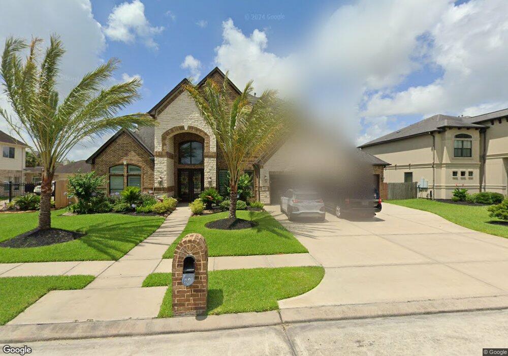
1731 Flat Rock St Friendswood, TX 77546
Estimated Value: $708,000 - $1,000,000
5
Beds
4
Baths
4,328
Sq Ft
$196/Sq Ft
Est. Value
About This Home
This home is located at 1731 Flat Rock St, Friendswood, TX 77546 and is currently estimated at $850,338, approximately $196 per square foot. 1731 Flat Rock St is a home located in Galveston County with nearby schools including C.W. Cline Elementary School, Windsong Elementary School, and Friendswood Junior High School.
Ownership History
Date
Name
Owned For
Owner Type
Purchase Details
Closed on
Apr 29, 2016
Sold by
National Transfer Services Llc
Bought by
Friberg Craig Allen and Friberg Angela Leigh
Current Estimated Value
Home Financials for this Owner
Home Financials are based on the most recent Mortgage that was taken out on this home.
Original Mortgage
$452,000
Outstanding Balance
$360,642
Interest Rate
3.73%
Mortgage Type
New Conventional
Estimated Equity
$489,696
Purchase Details
Closed on
Mar 29, 2010
Sold by
J Hill Investments Inc
Bought by
Genty Raymond A and Genty Tara L
Home Financials for this Owner
Home Financials are based on the most recent Mortgage that was taken out on this home.
Original Mortgage
$374,500
Interest Rate
5.75%
Mortgage Type
Construction
Create a Home Valuation Report for This Property
The Home Valuation Report is an in-depth analysis detailing your home's value as well as a comparison with similar homes in the area
Home Values in the Area
Average Home Value in this Area
Purchase History
| Date | Buyer | Sale Price | Title Company |
|---|---|---|---|
| Friberg Craig Allen | -- | Stewart Title Company | |
| National Transfer Services Llc | -- | Stewart Title Company | |
| Genty Raymond A | -- | American Title Co |
Source: Public Records
Mortgage History
| Date | Status | Borrower | Loan Amount |
|---|---|---|---|
| Open | Friberg Craig Allen | $452,000 | |
| Previous Owner | Genty Raymond A | $374,500 |
Source: Public Records
Tax History Compared to Growth
Tax History
| Year | Tax Paid | Tax Assessment Tax Assessment Total Assessment is a certain percentage of the fair market value that is determined by local assessors to be the total taxable value of land and additions on the property. | Land | Improvement |
|---|---|---|---|---|
| 2025 | $12,838 | $839,263 | -- | -- |
| 2024 | $12,838 | $762,966 | $50,900 | $712,066 |
| 2023 | $12,838 | $703,801 | $0 | $0 |
| 2022 | $14,092 | $639,819 | $50,900 | $588,919 |
| 2021 | $14,009 | $599,760 | $50,900 | $548,860 |
| 2020 | $14,106 | $585,500 | $50,900 | $534,600 |
| 2019 | $14,067 | $553,970 | $50,900 | $503,070 |
| 2018 | $14,150 | $553,970 | $50,900 | $503,070 |
| 2017 | $14,387 | $553,970 | $50,900 | $503,070 |
| 2016 | $13,051 | $542,940 | $50,900 | $492,040 |
| 2015 | $4,150 | $456,840 | $50,900 | $405,940 |
| 2014 | $4,101 | $435,840 | $50,200 | $385,640 |
Source: Public Records
Map
Nearby Homes
- 1804 Sandy Lake Dr
- 1305 Edgewater Dr
- 1302 Eagle Lakes Dr
- 1606 Falcon Ridge Blvd
- 1783 Lake Crest Ln
- 1668 Turner Ct
- 1608 Keystone Dr
- 111 Dunbar Unit 501
- 1217 Red Wing Dr
- 1804 Anna Way
- 1718 Avery Ln
- 1802 Creekside Dr
- 1906 Blue Quail Dr
- 1532 River Point Dr
- 1556 River Point Dr
- 2202 Calm Pond Ct
- 1572 River Point Dr
- 1568 River Point Dr
- 1588 River Point Dr
- 1564 River Point Dr
- 1736 Round Rock St
- 1874 Round Rock St
- 1732 Round Rock St
- 1877 Flat Rock St
- 1723 Flat Rock St
- 1736 Flat Rock St
- 1874 Flat Rock St
- 1732 Flat Rock St
- 1878 Round Rock St
- 1728 Round Rock St
- 1878 Flat Rock St
- 1728 Flat Rock St
- 1881 Flat Rock St
- 1731 Round Rock St
- 1731 Pampas Trail Dr
- 1719 Flat Rock St
- 1882 Flat Rock St
- 1873 Pampas Trail Dr
- 1727 Round Rock St
- 1873 Round Rock St