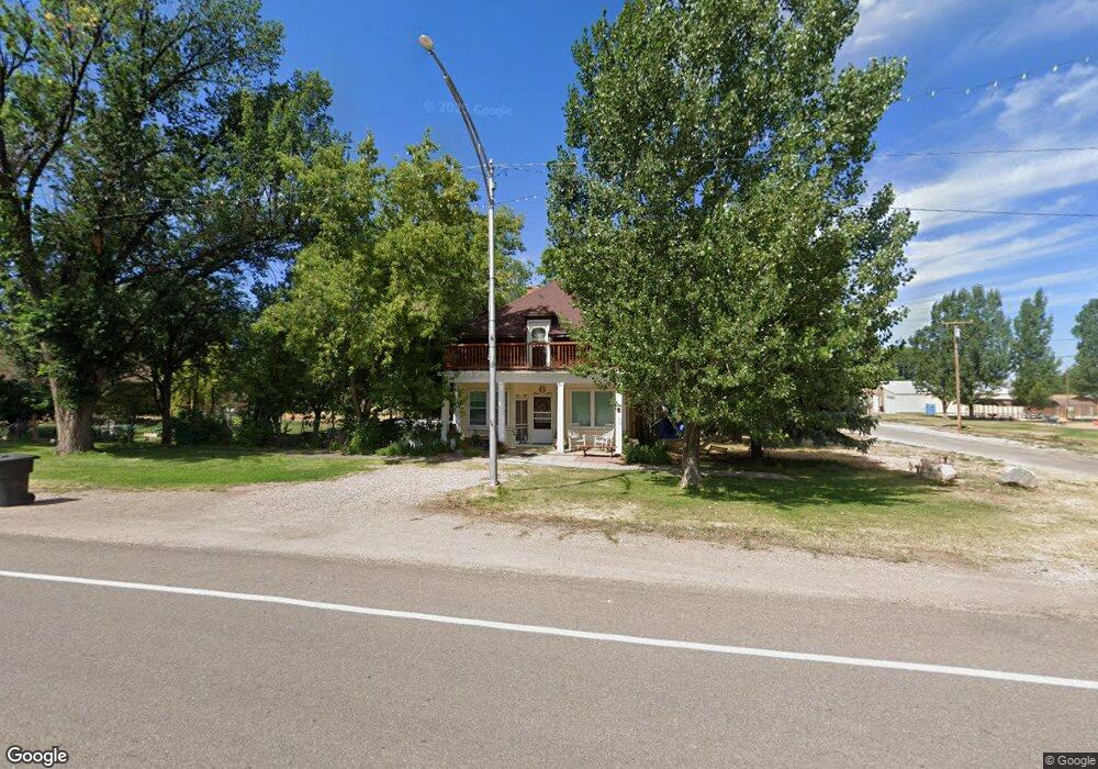
1731 N 900 W Paragonah, UT 84760
Estimated Value: $323,000 - $653,000
2
Beds
2
Baths
2,530
Sq Ft
$192/Sq Ft
Est. Value
About This Home
This home is located at 1731 N 900 W, Paragonah, UT 84760 and is currently estimated at $486,850, approximately $192 per square foot. 1731 N 900 W is a home located in Iron County with nearby schools including Parowan School, Parowan High School, and Cedar City High School.
Create a Home Valuation Report for This Property
The Home Valuation Report is an in-depth analysis detailing your home's value as well as a comparison with similar homes in the area
Home Values in the Area
Average Home Value in this Area
Tax History Compared to Growth
Tax History
| Year | Tax Paid | Tax Assessment Tax Assessment Total Assessment is a certain percentage of the fair market value that is determined by local assessors to be the total taxable value of land and additions on the property. | Land | Improvement |
|---|---|---|---|---|
| 2025 | $2,180 | $292,931 | $21,722 | $271,209 |
| 2023 | $2,188 | $310,740 | $17,000 | $293,740 |
| 2022 | $2,383 | $281,290 | $14,250 | $267,040 |
| 2021 | $1,652 | $194,995 | $14,250 | $180,745 |
| 2020 | $1,630 | $169,980 | $14,250 | $155,730 |
| 2019 | $1,548 | $154,800 | $14,250 | $140,550 |
| 2018 | $1,584 | $154,800 | $14,250 | $140,550 |
| 2017 | $1,449 | $142,250 | $15,250 | $127,000 |
| 2016 | $1,504 | $133,260 | $15,250 | $118,010 |
Source: Public Records
Map
Nearby Homes
- Lot 49
- 0 Lot 36 Flying Calute Rancheros Unit 109198
- 0 Unit 109207
- 17.93 Acres Parowan
- 1 AF Water Paragonah
- 0 75-2224 Unit 25-265390
- 0 75-2224 Unit 113245
- 40 N 100 W
- 1681 N Foothill Dr
- 0 1 Ac Ft of Water Unit 105918
- 0 Unit 113510
- 0 Unit 25-265934
- 0 1 Acre Ft of Water Unit 105916
- 0 1 Acre Ft of Water Unit 24-248977
- 0 20 Acres Near Parag Foothills
- Parowan Valley Water Rights
- 100 W 700 N
- 415 N 200 E
- 56 W 500 N
- 2660 N 2400 W
- 1731 N 900 W Unit 800
- 1731 N 900 W
- 1850 800 W
- 1850 N 800 W
- 0 C-0174-0001-0000 Unit 21-227867
- 0 C-0174-0001-0000 Unit 96266
- 0 Approx 910 West 3800 N
- 2121 N 800 E
- 2121 800 Rd W
- 2050 N 800 W
- 1950 N 800 W
- 2150 N 800 W
- 1950 800 W
- 2150 800 W
- I-15 Exit 82
- 0 19 49 Acres I-15 Ex: 82
- 0 T33s R8w Sec 20 NW Unit 21-223643
- 8.2 acres T33s R8w Sec 20
- 19.49 Ac I-15 Exit 82
- 0 Frontage Rd Unit 13-148138