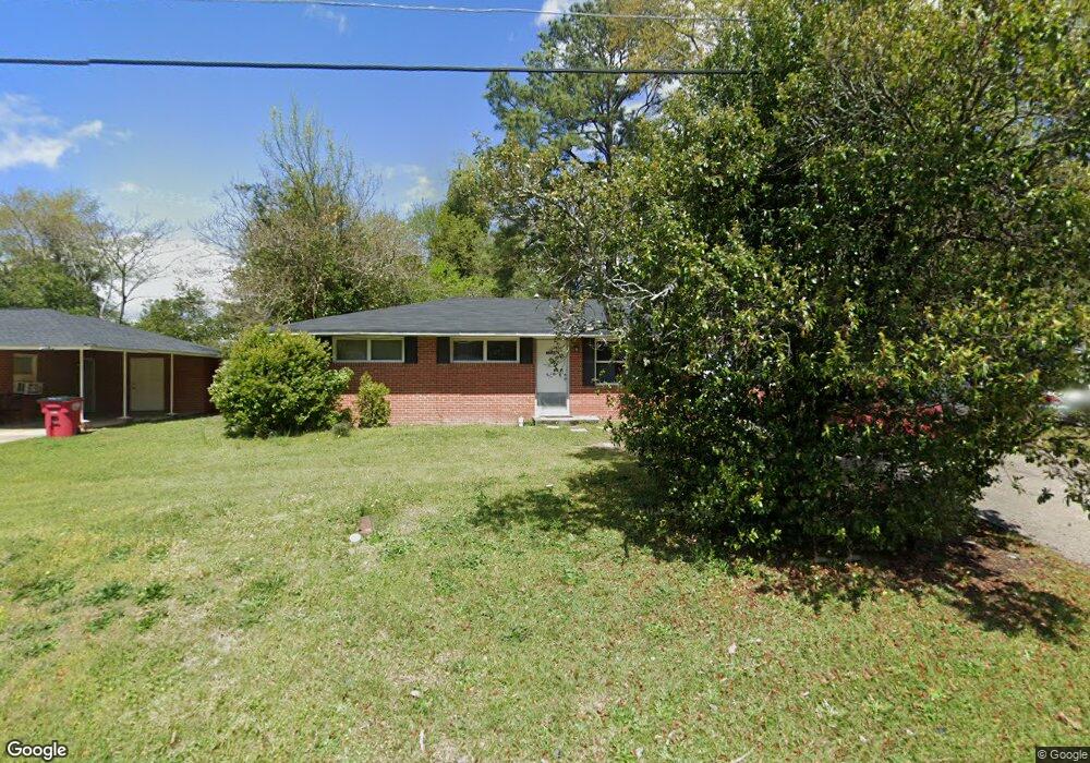
1731 Randall Rd Macon, GA 31206
Estimated Value: $71,916 - $84,000
3
Beds
1
Bath
1,264
Sq Ft
$61/Sq Ft
Est. Value
About This Home
This home is located at 1731 Randall Rd, Macon, GA 31206 and is currently estimated at $76,479, approximately $60 per square foot. 1731 Randall Rd is a home located in Bibb County with nearby schools including Southfield Elementary School, Southwest High School, and Cirrus Charter Academy.
Ownership History
Date
Name
Owned For
Owner Type
Purchase Details
Closed on
Jan 22, 2024
Sold by
Stephens Johnny
Bought by
Oak Pointe Capital Llc
Current Estimated Value
Purchase Details
Closed on
Jan 30, 2006
Sold by
Wilkes Paul E and Wilkes Wilma M
Bought by
Stephens Johnny
Create a Home Valuation Report for This Property
The Home Valuation Report is an in-depth analysis detailing your home's value as well as a comparison with similar homes in the area
Purchase History
| Date | Buyer | Sale Price | Title Company |
|---|---|---|---|
| Oak Pointe Capital Llc | $63,000 | None Listed On Document | |
| Oak Pointe Capital Llc | $63,000 | None Listed On Document | |
| Stephens Johnny | $45,000 | None Avilebel |
Source: Public Records
Tax History
| Year | Tax Paid | Tax Assessment Tax Assessment Total Assessment is a certain percentage of the fair market value that is determined by local assessors to be the total taxable value of land and additions on the property. | Land | Improvement |
|---|---|---|---|---|
| 2025 | $718 | $29,225 | $2,100 | $27,125 |
| 2024 | $742 | $29,225 | $2,100 | $27,125 |
| 2023 | $648 | $25,516 | $1,512 | $24,004 |
| 2022 | $576 | $16,639 | $1,325 | $15,314 |
| 2021 | $507 | $13,336 | $1,325 | $12,011 |
| 2020 | $439 | $11,305 | $795 | $10,510 |
| 2019 | $384 | $9,803 | $795 | $9,008 |
| 2018 | $678 | $8,302 | $795 | $7,507 |
| 2017 | $311 | $8,302 | $795 | $7,507 |
| 2016 | $261 | $7,552 | $795 | $6,756 |
| 2015 | $480 | $9,804 | $795 | $9,008 |
| 2014 | $765 | $13,581 | $1,325 | $12,256 |
Source: Public Records
Map
Nearby Homes
- 1748 Timark Dr
- 1748 Timark Dr
- 3445 Travis Blvd
- 3254 Markwood Dr
- 3446 Tamplin Terrace
- 3403 Tamplin Terrace
- 3751 Travis Blvd
- 1196 Harley St
- 1820 Sussex Dr
- 1792 Winston Dr
- 3391 Pio Nono Cir
- 3982 Saint Charles Place
- 1801 Winston Dr
- 1290 Pio Nono Cir
- 1254 W Grenada Terrace
- 1559 Rocky Creek Rd
- 3733 Lindsey Dr
- 3165 Ohara Dr N
- 2509 Kent Dr
- 3901 Shearwater Dr
- 1723 Randall Rd
- 1739 Randall Rd
- 1766 Timark Dr
- 1774 Timark Dr
- 1715 Randall Rd
- 1747 Randall Rd
- 1760 Timark Dr
- 1730 Randall Rd
- 1782 Timark Dr
- 1724 Randall Rd
- 1740 Randall Rd
- 1705 Randall Rd
- 1755 Randall Rd
- 1754 Timark Dr
- 1712 Randall Rd
- 1790 Timark Dr
- 1691 Randall Rd
- 1761 Randall Rd
- 1688 Sherrill Dr
- 1649 Mathis Cir
Your Personal Tour Guide
Ask me questions while you tour the home.