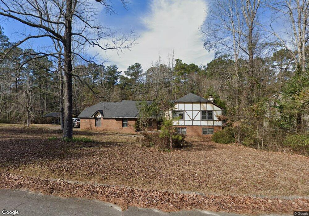
1733 Christophers Trace Macon, GA 31220
Estimated Value: $251,542 - $293,000
3
Beds
2
Baths
1,768
Sq Ft
$152/Sq Ft
Est. Value
About This Home
This home is located at 1733 Christophers Trace, Macon, GA 31220 and is currently estimated at $269,136, approximately $152 per square foot. 1733 Christophers Trace is a home located in Bibb County with nearby schools including Heritage Elementary School, Weaver Middle School, and Westside High School.
Ownership History
Date
Name
Owned For
Owner Type
Purchase Details
Closed on
May 17, 2007
Sold by
Vallett John and Jennings Gary
Bought by
Lee Cathy Q
Current Estimated Value
Home Financials for this Owner
Home Financials are based on the most recent Mortgage that was taken out on this home.
Original Mortgage
$154,395
Interest Rate
6.12%
Mortgage Type
Purchase Money Mortgage
Purchase Details
Closed on
Dec 14, 2006
Sold by
Suntrust Bank Middle Georgia Na
Bought by
Vallett John J and Jennings Gary
Home Financials for this Owner
Home Financials are based on the most recent Mortgage that was taken out on this home.
Original Mortgage
$146,392
Interest Rate
6.29%
Mortgage Type
New Conventional
Create a Home Valuation Report for This Property
The Home Valuation Report is an in-depth analysis detailing your home's value as well as a comparison with similar homes in the area
Purchase History
| Date | Buyer | Sale Price | Title Company |
|---|---|---|---|
| Lee Cathy Q | $151,350 | None Available | |
| Vallett John J | -- | None Avilabale |
Source: Public Records
Mortgage History
| Date | Status | Borrower | Loan Amount |
|---|---|---|---|
| Closed | Lee Cathy Q | $154,395 | |
| Previous Owner | Vallett John J | $146,392 |
Source: Public Records
Tax History
| Year | Tax Paid | Tax Assessment Tax Assessment Total Assessment is a certain percentage of the fair market value that is determined by local assessors to be the total taxable value of land and additions on the property. | Land | Improvement |
|---|---|---|---|---|
| 2025 | $2,118 | $86,192 | $10,000 | $76,192 |
| 2024 | $1,967 | $77,444 | $10,000 | $67,444 |
| 2023 | $2,294 | $77,444 | $10,000 | $67,444 |
| 2022 | $2,909 | $84,027 | $12,141 | $71,886 |
| 2021 | $2,130 | $56,053 | $12,141 | $43,912 |
| 2020 | $2,176 | $56,053 | $12,141 | $43,912 |
| 2019 | $2,194 | $56,053 | $12,141 | $43,912 |
| 2018 | $3,533 | $55,939 | $12,141 | $43,798 |
| 2017 | $2,096 | $55,939 | $12,141 | $43,798 |
| 2016 | $1,935 | $55,939 | $12,141 | $43,798 |
| 2015 | $2,739 | $55,939 | $12,141 | $43,798 |
| 2014 | $2,744 | $55,939 | $12,141 | $43,798 |
Source: Public Records
Map
Nearby Homes
- 6806 Bay Point Dr
- 1301 Johnson Rd
- 129 Harbor Dr
- 147 Harbor Dr
- 159 Harbor Dr
- 153 Harbor Dr
- 165 Harbor Dr
- 221 Shoreline Way
- 213 Shoreline Way
- 171 Harbor Dr
- 177 Harbor Dr
- 116 Nautica Point
- 209 Shoreline Way
- 250 Shoreline Way
- 7023 Moseley Dixon Rd
- 1570 Johnson Rd
- 312 Pinnacle Park
- 2617 Penbrook Ln
- 349 Hillridge Cove
- 1412 Johnson Rd
- 1721 Christophers Trace
- 1709 Christophers Trace
- 1708 Kays Ct
- 1740 Christophers Trace
- 1726 Christophers Trace
- 6638 Dana Dr
- 1718 Christophers Trace
- 1766 Christophers Trace
- 6652 Dana Dr
- 1771 Christophers Trace
- 1710 Christophers Trace
- 6658 Dana Dr
- 1739 Kays Ct
- 1780 Christophers Trace
- 1732 Kays Ct
- 6670 Dana Dr
- 216 Saint Anthonys Dr
- 214 Saint Anthonys Dr
- 214 St Anthonys Dr
- 1787 Christophers Trace
Your Personal Tour Guide
Ask me questions while you tour the home.