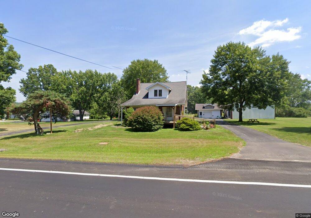
1734 State Route 7 NE Brookfield, OH 44403
Estimated Value: $165,054 - $251,000
4
Beds
2
Baths
1,654
Sq Ft
$124/Sq Ft
Est. Value
About This Home
This home is located at 1734 State Route 7 NE, Brookfield, OH 44403 and is currently estimated at $204,764, approximately $123 per square foot. 1734 State Route 7 NE is a home located in Trumbull County with nearby schools including Brookfield Elementary School, Brookfield Middle School, and Brookfield High School.
Ownership History
Date
Name
Owned For
Owner Type
Purchase Details
Closed on
Dec 22, 2009
Sold by
Estate Of Elizabeth E Vrankovich
Bought by
Simion Sharon and Maykowski Bonita
Current Estimated Value
Purchase Details
Closed on
Dec 21, 2009
Sold by
Simion Sharon L and Simion James G
Bought by
Vrankovich George and Vrankovich Kathryn
Purchase Details
Closed on
Mar 10, 2003
Sold by
Vrankovich Frank
Bought by
Vrankovich Elizabeth
Purchase Details
Closed on
Jan 1, 1990
Bought by
Frank and Frank Elizabeth E
Create a Home Valuation Report for This Property
The Home Valuation Report is an in-depth analysis detailing your home's value as well as a comparison with similar homes in the area
Home Values in the Area
Average Home Value in this Area
Purchase History
| Date | Buyer | Sale Price | Title Company |
|---|---|---|---|
| Simion Sharon | -- | None Available | |
| Vrankovich George | -- | Attorney | |
| Vrankovich Elizabeth | -- | -- | |
| Frank | -- | -- |
Source: Public Records
Tax History Compared to Growth
Tax History
| Year | Tax Paid | Tax Assessment Tax Assessment Total Assessment is a certain percentage of the fair market value that is determined by local assessors to be the total taxable value of land and additions on the property. | Land | Improvement |
|---|---|---|---|---|
| 2024 | $1,794 | $44,250 | $740 | $43,510 |
| 2023 | $1,794 | $44,250 | $740 | $43,510 |
| 2022 | $1,485 | $29,930 | $670 | $29,260 |
| 2021 | $1,482 | $29,930 | $670 | $29,260 |
| 2020 | $1,497 | $29,930 | $670 | $29,260 |
| 2019 | $1,436 | $26,740 | $630 | $26,110 |
| 2018 | $1,423 | $26,740 | $630 | $26,110 |
| 2017 | $1,419 | $26,740 | $630 | $26,110 |
| 2016 | $1,410 | $25,520 | $630 | $24,890 |
| 2015 | $1,413 | $25,520 | $630 | $24,890 |
| 2014 | $1,406 | $25,520 | $630 | $24,890 |
| 2013 | $1,479 | $27,370 | $630 | $26,740 |
Source: Public Records
Map
Nearby Homes
- 1212 State Route 7 NE
- 1921 Custer Orangeville Rd
- 209 Wyngate Dr
- 7974 Thompson Sharpsville Rd
- 8038 Thompson Sharpsville Rd
- 7131 Drake Stateline Rd NE
- 7155 Drake State Line Rd
- 0 Albright McKay Rd NE
- 8274 Thompson Sharpsville Rd
- 718 State Route 7 NE
- 7091 Warren Sharon Rd
- 6984 Warren Sharon Rd
- 7086 Warren Sharon Rd
- 6333 Warren Sharon Rd
- 2601 Orangeville Rd
- 872 Yankee Run Rd
- 2701 Orangeville Rd
- 6130 Warren Sharon Rd
- 7954 Warren - Sharon Rd
- 461 Grove St
- 1710 State Route 7 NE
- 7046 Fairview Ave
- 1747 State Route 7 NE
- 7040 Brockway Ave
- 7051 Fairview Ave
- 7051 Fairview Ave
- 6991 Amy Boyle Rd NE
- 7048 Brockway Ave
- 7076 Fairview Ave
- 7076 Fairview Ave
- 6979 Amy Boyle Rd NE
- 1786 State Route 7 NE
- 7037 Brockway Ave
- 7078 Brockway Ave
- 1781 State Route 7 NE
- 1781 State Route 7 NE
- 7098 Fairview Ave
- 7090 Brockway Ave
- 7090 Brockway Ave
- 7090 Brockway Ave