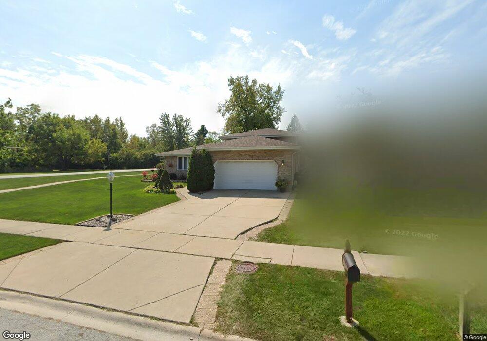
17354 Arrowhead Trace Oak Forest, IL 60452
Estimated Value: $330,000 - $388,000
3
Beds
3
Baths
1,240
Sq Ft
$281/Sq Ft
Est. Value
About This Home
This home is located at 17354 Arrowhead Trace, Oak Forest, IL 60452 and is currently estimated at $347,926, approximately $280 per square foot. 17354 Arrowhead Trace is a home located in Cook County with nearby schools including Kimberly Heights Elementary School, Scarlet Oak Elementary School, and Arbor Park Middle School.
Ownership History
Date
Name
Owned For
Owner Type
Purchase Details
Closed on
Apr 4, 1996
Sold by
Mcgregor William and Mcgregor Mary
Bought by
Ledger Gilbert E and Ledger Susan M
Current Estimated Value
Home Financials for this Owner
Home Financials are based on the most recent Mortgage that was taken out on this home.
Original Mortgage
$144,500
Outstanding Balance
$4,137
Interest Rate
7.91%
Estimated Equity
$343,789
Create a Home Valuation Report for This Property
The Home Valuation Report is an in-depth analysis detailing your home's value as well as a comparison with similar homes in the area
Home Values in the Area
Average Home Value in this Area
Purchase History
| Date | Buyer | Sale Price | Title Company |
|---|---|---|---|
| Ledger Gilbert E | $160,500 | Intercounty Title |
Source: Public Records
Mortgage History
| Date | Status | Borrower | Loan Amount |
|---|---|---|---|
| Open | Ledger Gilbert E | $144,500 |
Source: Public Records
Tax History
| Year | Tax Paid | Tax Assessment Tax Assessment Total Assessment is a certain percentage of the fair market value that is determined by local assessors to be the total taxable value of land and additions on the property. | Land | Improvement |
|---|---|---|---|---|
| 2025 | $8,749 | $27,506 | $6,786 | $20,720 |
| 2024 | $8,749 | $27,506 | $6,786 | $20,720 |
| 2023 | $9,030 | $27,506 | $6,786 | $20,720 |
| 2022 | $9,030 | $22,805 | $6,003 | $16,802 |
| 2021 | $8,848 | $22,805 | $6,003 | $16,802 |
| 2020 | $8,630 | $22,805 | $6,003 | $16,802 |
| 2019 | $9,286 | $24,124 | $5,481 | $18,643 |
| 2018 | $9,079 | $24,124 | $5,481 | $18,643 |
| 2017 | $9,063 | $24,124 | $5,481 | $18,643 |
| 2016 | $8,841 | $21,981 | $4,698 | $17,283 |
| 2015 | $8,534 | $21,981 | $4,698 | $17,283 |
| 2014 | $8,346 | $21,981 | $4,698 | $17,283 |
| 2013 | $8,717 | $25,389 | $4,698 | $20,691 |
Source: Public Records
Map
Nearby Homes
- 5048 171st St
- 5417 Christopher Dr
- 5319 Martha Ln
- 5524 Christopher Dr
- 17027 Judy Ct
- 4847 175th St
- 5426 Bonnie Trail
- 16908 Laramie Ave
- 16909 W Thackeray Lot #8 St
- 16938 Cicero Ave
- 17140 Central Ave
- 16861 Thackery Ave
- 5113 Coulter Rd
- 4656 176th Place
- 5166 Aldersyde Rd
- 4657 176th Place
- 17526 Mulberry St
- 4645 Milford Ave
- 4411 177th Place
- 18300 Lavergne Ave
- 17348 Arrowhead Trace
- 17342 Arrowhead Trace
- 17336 Arrowhead Trace
- 17380 Brennan Hwy
- 17349 Arrowhead Trace
- 17343 Arrowhead Trace
- 17337 Arrowhead Trace
- 17330 Arrowhead Trace
- 17331 Arrowhead Trace
- 17324 Arrowhead Trace
- 17325 Arrowhead Trace
- 17390 Brennan Hwy
- 17333 Brennan Hwy
- 17303 Brennan Hwy
- 17318 Arrowhead Trace
- 17319 Arrowhead Trace
- 17399 Brennan Hwy
- 17301 George Brennan Hwy
- 17330 Brennan Hwy
- 17313 Arrowhead Trace
Your Personal Tour Guide
Ask me questions while you tour the home.