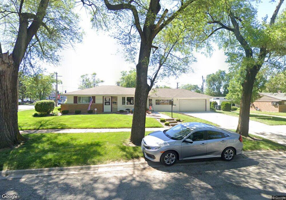
17356 Walter St Lansing, IL 60438
Estimated Value: $166,000 - $435,208
3
Beds
1
Bath
1,265
Sq Ft
$194/Sq Ft
Est. Value
About This Home
This home is located at 17356 Walter St, Lansing, IL 60438 and is currently estimated at $245,802, approximately $194 per square foot. 17356 Walter St is a home located in Cook County with nearby schools including Reavis Elementary School, Memorial Jr High School, and Thornton Fractnl So High School.
Ownership History
Date
Name
Owned For
Owner Type
Purchase Details
Closed on
Dec 15, 2022
Sold by
Przybyl Lorraine M
Bought by
Lorraine M Przybyl Declaration Of Trust
Current Estimated Value
Purchase Details
Closed on
Jan 26, 1996
Sold by
Przybyl David D and Przybyl Lorraine
Bought by
Przybyl David D and Przybyl Lorraine
Home Financials for this Owner
Home Financials are based on the most recent Mortgage that was taken out on this home.
Original Mortgage
$57,000
Interest Rate
7.24%
Create a Home Valuation Report for This Property
The Home Valuation Report is an in-depth analysis detailing your home's value as well as a comparison with similar homes in the area
Home Values in the Area
Average Home Value in this Area
Purchase History
| Date | Buyer | Sale Price | Title Company |
|---|---|---|---|
| Lorraine M Przybyl Declaration Of Trust | $500,000 | None Listed On Document | |
| Przybyl David D | -- | -- |
Source: Public Records
Mortgage History
| Date | Status | Borrower | Loan Amount |
|---|---|---|---|
| Previous Owner | Przybyl David D | $57,000 |
Source: Public Records
Tax History Compared to Growth
Tax History
| Year | Tax Paid | Tax Assessment Tax Assessment Total Assessment is a certain percentage of the fair market value that is determined by local assessors to be the total taxable value of land and additions on the property. | Land | Improvement |
|---|---|---|---|---|
| 2024 | $874 | $12,000 | $3,442 | $8,558 |
| 2023 | $767 | $12,000 | $3,442 | $8,558 |
| 2022 | $767 | $8,021 | $3,011 | $5,010 |
| 2021 | $860 | $8,021 | $3,011 | $5,010 |
| 2020 | $901 | $8,021 | $3,011 | $5,010 |
| 2019 | $967 | $9,166 | $2,796 | $6,370 |
| 2018 | $951 | $9,166 | $2,796 | $6,370 |
| 2017 | $943 | $9,166 | $2,796 | $6,370 |
| 2016 | $2,136 | $9,123 | $2,581 | $6,542 |
| 2015 | $2,085 | $9,123 | $2,581 | $6,542 |
| 2014 | $1,446 | $9,123 | $2,581 | $6,542 |
| 2013 | $4,523 | $10,045 | $2,581 | $7,464 |
Source: Public Records
Map
Nearby Homes
- 17318 Walter St
- 17256 Walter St
- 17303 Roy St
- 17335 Community St
- 17331 Community St
- 17518 Roy St
- 17226 Community St
- 3409 173rd Place
- 17519 Community St
- 3026 Bernice Rd Unit 308
- 17153 Walter St
- 17552 Roy St
- 17132 Walter St
- 17303 Chicago Ave
- 3425 Bernice Ave
- 17218 Park Ave
- 17614 Community St
- 17603 Community St
- 2950 Bernice Rd
- 17128 Grant St
- 3214 Bernice Rd
- 17340 Walter St
- 3234 Bernice Rd
- 3234 Bernice Rd
- 17336 Walter St
- 17353 Burnham Ave
- 17357 Burnham Ave
- 17347 Burnham Ave
- 3238 Bernice Rd
- 3238 Bernice Rd
- 17343 Burnham Ave
- 17343 Burnham Ave
- 17341 Walter St
- 17332 Walter St
- 17406 Walter St
- 3215 Bernice Rd
- 17339 Burnham Ave
- 17337 Walter St
- 3244 Bernice Rd
- 17405 Walter St