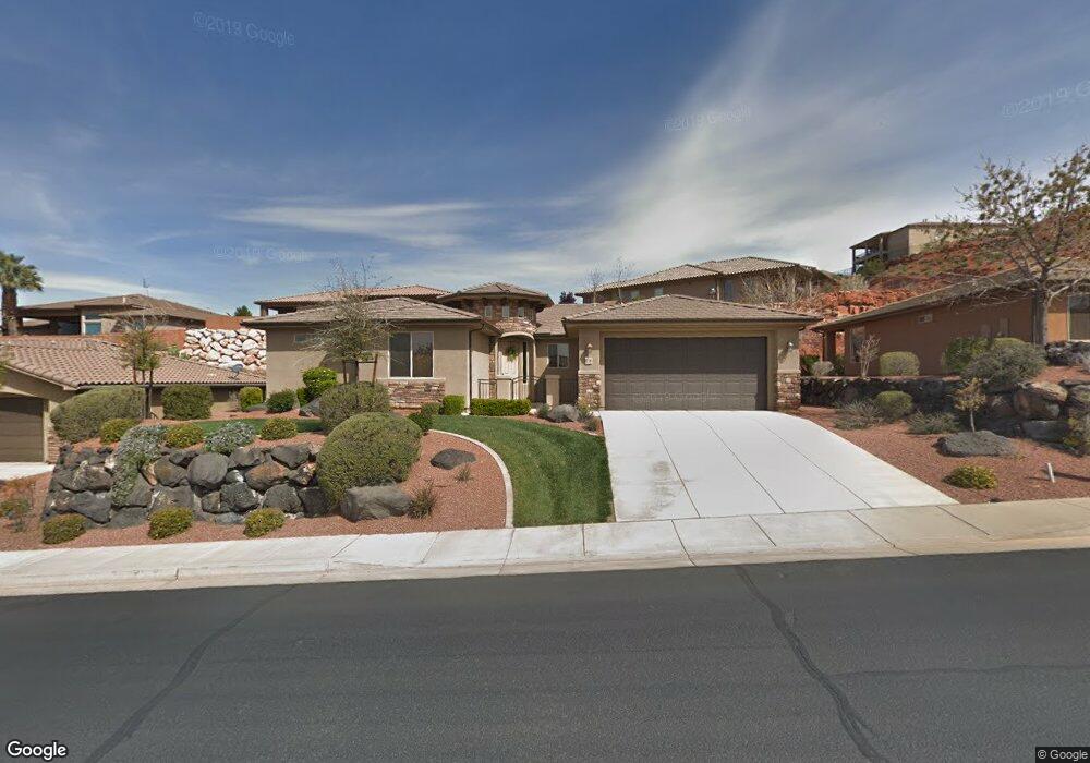
1736 Lakota Dr Unit 9 St. George, UT 84770
Estimated Value: $578,682 - $728,000
4
Beds
3
Baths
2,180
Sq Ft
$306/Sq Ft
Est. Value
About This Home
This home is located at 1736 Lakota Dr Unit 9, St. George, UT 84770 and is currently estimated at $666,421, approximately $305 per square foot. 1736 Lakota Dr Unit 9 is a home located in Washington County with nearby schools including Snow Canyon Middle School, Diamond Valley School, and Lava Ridge Intermediate School.
Ownership History
Date
Name
Owned For
Owner Type
Purchase Details
Closed on
May 25, 2018
Sold by
Lewis Dori Ann and Snyder Dori Ann
Bought by
Howell Elizabeth Anderson
Current Estimated Value
Purchase Details
Closed on
Nov 8, 2011
Sold by
Ence Bros Construction Inc
Bought by
Lewis Dori Ann
Purchase Details
Closed on
Mar 23, 2010
Sold by
Zions First National Bank
Bought by
Ence Bros Construction Inc
Purchase Details
Closed on
Nov 10, 2009
Sold by
Pathway Holdings Of Utah Llc
Bought by
Zions First National Bank
Purchase Details
Closed on
May 16, 2006
Sold by
Lakota Ridge Llc
Bought by
Pathway Holding Of Utah Llc
Purchase Details
Closed on
Apr 13, 2006
Sold by
Snow Canyon Partners Llc
Bought by
Lakota Ridge Llc
Create a Home Valuation Report for This Property
The Home Valuation Report is an in-depth analysis detailing your home's value as well as a comparison with similar homes in the area
Home Values in the Area
Average Home Value in this Area
Purchase History
| Date | Buyer | Sale Price | Title Company |
|---|---|---|---|
| Howell Elizabeth Anderson | -- | Southern Utah Title Co | |
| Lewis Dori Ann | -- | Southern Utah Title | |
| Ence Bros Construction Inc | -- | Southern Utah Title | |
| Zions First National Bank | -- | None Available | |
| Pathway Holding Of Utah Llc | -- | Southern Utah Title Co | |
| Lakota Ridge Llc | -- | Southern Utah Title Co |
Source: Public Records
Tax History Compared to Growth
Tax History
| Year | Tax Paid | Tax Assessment Tax Assessment Total Assessment is a certain percentage of the fair market value that is determined by local assessors to be the total taxable value of land and additions on the property. | Land | Improvement |
|---|---|---|---|---|
| 2025 | $3,557 | $538,200 | $160,000 | $378,200 |
| 2023 | $3,910 | $584,200 | $150,000 | $434,200 |
| 2022 | $4,102 | $576,300 | $140,000 | $436,300 |
| 2021 | $3,439 | $396,300 | $80,000 | $316,300 |
| 2020 | $3,325 | $360,900 | $80,000 | $280,900 |
| 2019 | $3,250 | $344,600 | $70,000 | $274,600 |
| 2018 | $3,168 | $315,300 | $0 | $0 |
| 2017 | $1,714 | $165,660 | $0 | $0 |
| 2016 | $1,721 | $153,835 | $0 | $0 |
| 2015 | $1,777 | $152,405 | $0 | $0 |
| 2014 | $1,916 | $165,330 | $0 | $0 |
Source: Public Records
Map
Nearby Homes
- 1996 W 1940 N
- 1989 W 1800 N
- 2294 N Gunsight Dr
- 1795 N Snow Canyon Parkway #40
- 1806 N Dixie Downs Rd Unit 27
- 1806 N Dixie Downs Rd Unit 27
- 1806 N Dixie Downs Rd Unit 29
- 1806 N Dixie Downs Rd Unit 29
- 2090 N Tuweap Dr Unit 13
- 2090 N Tuweap Dr Unit 9
- 2090 N Tuweap Dr Unit 15
- 2090 N Tuweap Dr Unit 56
- 1708 N 1975 W
- 1795 N Snow Canyon Pkwy Unit 28
- 1795 N Snow Canyon Pkwy Unit 59
- 1795 N Snow Canyon Pkwy Unit 40
- 1795 N Snow Canyon Pkwy Unit 40
- 1756 N 2065 W
- 2195 W 1970 Cir N
- 1574 N Dixie Downs Rd Unit 55
- 1750 W Lakota Dr
- 1722 W Lakota Dr Unit 10
- 1743 W Gunsight Dr
- 1731 W Gunsight Dr
- 1900 N Lakota Cir Unit 6
- 1920 N Lakota Cir Unit 8
- 1900 N Lakota Cir Unit 16
- 1900 N Lakota Cir Unit 18
- 1920 N Lakota Cir
- 1984 N Lakota Cir
- 1708 Lakota Dr Unit Lot 11
- 1747 W Lakota Dr Unit 21
- 1757 W Gunsight Dr
- 75 W Gunsight Dr
- 0 Lakota Dr Unit 34 10-121920
- 0 Lakota Dr Unit 38
- 1705 W Lakota Dr
- 0 N Lakota Cir Unit 86 10-121916
- 0 N Lakota Cir Unit 45 10-121917
- 0 N Lakota Cir Unit 30 12-134555