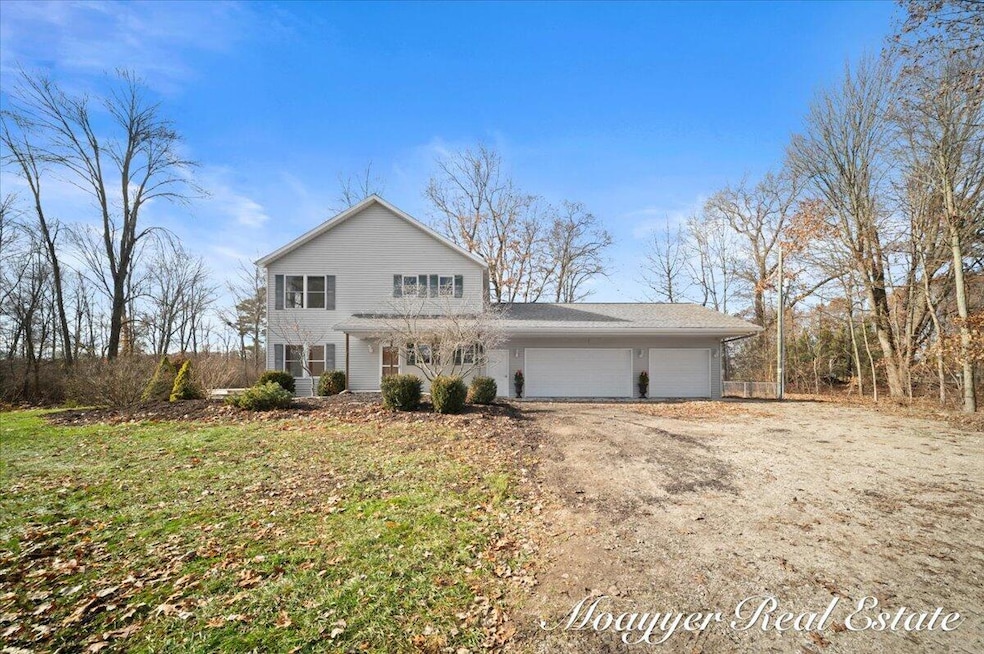
1736 Parker Dr Wayland, MI 49348
Estimated payment $6,125/month
Highlights
- Private Waterfront
- Deck
- Traditional Architecture
- 1.7 Acre Lot
- Wooded Lot
- 1-minute walk to Yankee Springs Township Park
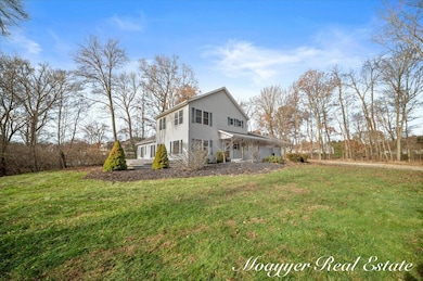
About This Home
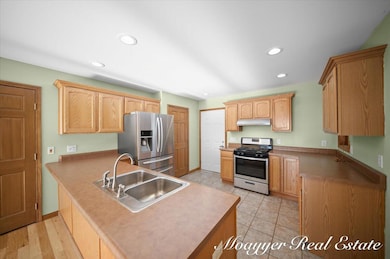
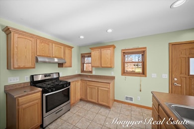
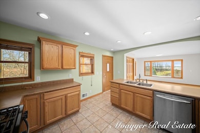
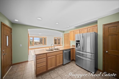
Rare opportunity to own one of the most coveted locations on Gun lake! This stunning property boasts approximately 1.7 acres of gentle, fully usable lake frontage with panoramic water views, a private frontage area, and deep-water access perfect for boating, swimming, and year-round lakeside living and a $100K, 30X40 pole barn for storage. The spacious 5-bedroom, 4-bathroom home offers over 2400 of well-designed living space, ideal for family gatherings or entertaining. Light-filled open floor plan, open kitchen, primary suite with lake views, multiple living areas, and ample storage throughout.
Exclusive Purchase Option: The savvy buyer has the rare ability to acquire the adjacent 1.3-acre parcel, bringing the total estate to an expansive 3 private acres — creating one of the largest lakefront holdings currently available in the area. Perfect for added privacy, a guest house, tennis court, or simply preserving your unobstructed views forever. Properties with this combination of acreage, frontage, and location almost never come to market. Whether you take the core 1.7-acre parcel or expand to the full 3 acres, this is a once-in-a-generation chance to secure the absolute best spot on the lake. Priced to sell - inquire today for private showing and full details on the additional 1.3-acre option.
Home Details
Home Type
- Single Family
Est. Annual Taxes
- $12,061
Year Built
- Built in 2006
Lot Details
- 1.7 Acre Lot
- Lot Dimensions are 75x374x524x400x435x90
- Private Waterfront
- 100 Feet of Waterfront
- Wooded Lot
- Property is zoned RES1, RES1
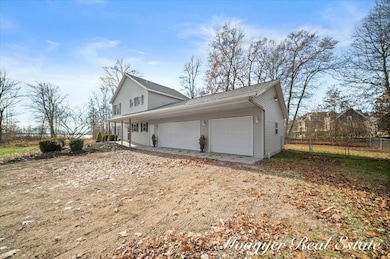
Parking
- 3 Car Attached Garage
- Gravel Driveway
Home Design
- Traditional Architecture
- Slab Foundation
- Shingle Roof
- Vinyl Siding
Interior Spaces
- 2,400 Sq Ft Home
- 2-Story Property
- Low Emissivity Windows
- Insulated Windows
Kitchen
- Oven
- Dishwasher
Flooring
- Wood
- Carpet
Bedrooms and Bathrooms
- 5 Bedrooms | 2 Main Level Bedrooms
- 4 Full Bathrooms
Laundry
- Laundry on main level
- Dryer
- Washer
Outdoor Features
- Water Access
- Property is near a lake
- Deck
Utilities
- Dehumidifier
- Forced Air Heating and Cooling System
- Heating System Uses Natural Gas
- Hot Water Heating System
- Natural Gas Water Heater
Community Details
- No Home Owners Association
Map
Home Values in the Area
Average Home Value in this Area
Tax History
| Year | Tax Paid | Tax Assessment Tax Assessment Total Assessment is a certain percentage of the fair market value that is determined by local assessors to be the total taxable value of land and additions on the property. | Land | Improvement |
|---|---|---|---|---|
| 2025 | $12,061 | $445,300 | $0 | $0 |
| 2024 | $12,061 | $405,700 | $0 | $0 |
| 2023 | $11,156 | $294,600 | $0 | $0 |
| 2022 | $11,156 | $294,600 | $0 | $0 |
| 2021 | $11,156 | $272,400 | $0 | $0 |
| 2020 | $10,866 | $265,800 | $0 | $0 |
| 2019 | $10,866 | $264,400 | $0 | $0 |
| 2018 | $6,292 | $244,400 | $128,500 | $115,900 |
| 2017 | $6,292 | $244,400 | $0 | $0 |
| 2016 | -- | $229,100 | $0 | $0 |
| 2015 | -- | $211,000 | $0 | $0 |
| 2014 | -- | $211,000 | $0 | $0 |
Property History
| Date | Event | Price | List to Sale | Price per Sq Ft |
|---|---|---|---|---|
| 11/25/2025 11/25/25 | For Sale | $969,500 | -- | $404 / Sq Ft |
Purchase History
| Date | Type | Sale Price | Title Company |
|---|---|---|---|
| Interfamily Deed Transfer | -- | None Available | |
| Interfamily Deed Transfer | -- | None Available | |
| Interfamily Deed Transfer | -- | Metropolitan Title Company | |
| Warranty Deed | $285,000 | Metropolitan Title Company | |
| Sheriffs Deed | $361,287 | None Available |
Mortgage History
| Date | Status | Loan Amount | Loan Type |
|---|---|---|---|
| Closed | $185,000 | Purchase Money Mortgage |
Source: MichRIC
MLS Number: 25059774
APN: 16-019-001-09
Disclaimer: Certain information contained herein is derived from information provided by parties other than Homes.com. All information provided is deemed reliable, but is not guaranteed to be accurate and should be independently verified.
![]() Information is deemed reliable but not guaranteed.
Information is deemed reliable but not guaranteed.
Copyright 2025 MichRIC, LLC. All rights reserved.
- 1815 Parker Dr
- 1875 Edwin Dr
- 1980 Parker Dr
- 12169 Pine Meadows Dr
- 2065 S Patterson Rd
- 12712 Sunrise Ct
- 12031 Sandstone Dr
- 2681 Cutlass St
- 35 Cannonball Ln
- 2724 Pasture Ln
- 11065 W M 179 Hwy
- 3140 Sandy Beach St
- 12940 Cleland Ave
- 3298 Elmwood Beach Rd
- 2919 Beatrice Ave
- 2919 Beatrice Ave
- 0 Spruce Hollow Dr Unit Parcel B
- 1164 E Bernie Ct
- 12720 S Grey Ct
- 11908 Erica Ln Unit Site 66
- 532 Forrest St
- 317 W Main St Unit B
- 822 Midvilla Ln
- 607 Trinity Dr Unit 1
- 5317 W Cloverdale Rd
- 245 Kinsey St SE
- 301 S Maple St SE
- 215 S Maple St SE
- 7100 92nd St SE
- 326 W State St
- 6287 Laneview Dr SE
- 8522 Jasonville Ct SE Unit 8522
- 1611 S Hanover St
- 768 Four Ponds Ct SE
- 8920 Pictured Rock Dr
- 7020 Whitneyville Ave SE
- 6020 W Fieldstone Hills Dr SE
- 3500-3540 60th St
- 5012 Verdure Pkwy
- 1414 Eastport Dr SE
