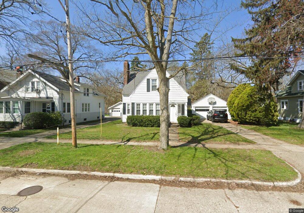
1737 McGraft St Muskegon, MI 49441
Nims NeighborhoodEstimated Value: $214,000 - $232,000
3
Beds
2
Baths
1,000
Sq Ft
$222/Sq Ft
Est. Value
About This Home
This home is located at 1737 McGraft St, Muskegon, MI 49441 and is currently estimated at $222,182, approximately $222 per square foot. 1737 McGraft St is a home located in Muskegon County with nearby schools including Muskegon Catholic Central School and St. Michael Elementary School.
Ownership History
Date
Name
Owned For
Owner Type
Purchase Details
Closed on
Jun 4, 2004
Sold by
Schmidt Jeffrey H and Schmidt Kristi L
Bought by
Reagan Patrick and Reagan Karen B
Current Estimated Value
Home Financials for this Owner
Home Financials are based on the most recent Mortgage that was taken out on this home.
Original Mortgage
$98,356
Outstanding Balance
$48,274
Interest Rate
6.06%
Mortgage Type
FHA
Estimated Equity
$173,909
Create a Home Valuation Report for This Property
The Home Valuation Report is an in-depth analysis detailing your home's value as well as a comparison with similar homes in the area
Home Values in the Area
Average Home Value in this Area
Purchase History
| Date | Buyer | Sale Price | Title Company |
|---|---|---|---|
| Reagan Patrick | $99,900 | -- |
Source: Public Records
Mortgage History
| Date | Status | Borrower | Loan Amount |
|---|---|---|---|
| Open | Reagan Patrick | $98,356 |
Source: Public Records
Tax History Compared to Growth
Tax History
| Year | Tax Paid | Tax Assessment Tax Assessment Total Assessment is a certain percentage of the fair market value that is determined by local assessors to be the total taxable value of land and additions on the property. | Land | Improvement |
|---|---|---|---|---|
| 2025 | $2,285 | $103,700 | $0 | $0 |
| 2024 | $587 | $85,600 | $0 | $0 |
| 2023 | $561 | $75,800 | $0 | $0 |
| 2022 | $2,072 | $62,700 | $0 | $0 |
| 2021 | $2,035 | $55,200 | $0 | $0 |
| 2020 | $1,973 | $48,200 | $0 | $0 |
| 2019 | $1,938 | $42,900 | $0 | $0 |
| 2018 | $1,894 | $45,500 | $0 | $0 |
| 2017 | $1,828 | $43,300 | $0 | $0 |
| 2016 | $478 | $41,300 | $0 | $0 |
| 2015 | -- | $41,700 | $0 | $0 |
| 2014 | $469 | $41,900 | $0 | $0 |
| 2013 | -- | $39,800 | $0 | $0 |
Source: Public Records
Map
Nearby Homes
- 1151 W Dale Ave
- 1135 W Dale Ave
- 952 Boardwalk Cove Dr
- 1472 Montgomery Ave
- 1270 Palmer Ave
- 1092 Ireland Ave
- 1636 Franklin St
- 988 W Larch Ave
- 1465 Barclay St
- 972 W Dale Ave
- 995 W Southern Ave
- VL Washington
- 929 Ireland Ave
- 933 W Southern Ave
- 923 W Southern Ave
- 905 W Forest Ave
- 1794 Lakeshore Dr
- 899 W Southern Ave
- 1776 Division St
- 902 W Southern Ave
- 1751 McGraft St
- 1733 McGraft St
- 1757 McGraft St
- 1723 McGraft St
- 1765 McGraft St
- 1355 Montgomery Ave
- 1345 Montgomery Ave
- 1351 Montgomery Ave
- 1732 McGraft St
- 1773 McGraft St
- 1722 McGraft St
- 1365 Montgomery Ave
- 1750 McGraft St
- 1709 McGraft St
- 1369 Montgomery Ave
- 1337 Montgomery Ave
- 1705 McGraft St
- 1714 McGraft St
- 1766 McGraft St
- 1333 Montgomery Ave