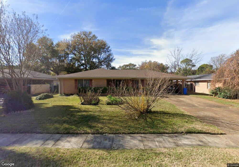
1738 Captain Shreve Dr Shreveport, LA 71105
Broadmoor/Anderson Island/Shreve Isle NeighborhoodEstimated Value: $166,000 - $203,223
3
Beds
2
Baths
1,858
Sq Ft
$102/Sq Ft
Est. Value
About This Home
This home is located at 1738 Captain Shreve Dr, Shreveport, LA 71105 and is currently estimated at $189,806, approximately $102 per square foot. 1738 Captain Shreve Dr is a home located in Caddo Parish with nearby schools including Fairfield Magnet School, Judson Fundamental Elementary School, and Eden Gardens Fundamental Elementary School.
Ownership History
Date
Name
Owned For
Owner Type
Purchase Details
Closed on
Sep 13, 2013
Sold by
Florey Rosemary La Basse
Bought by
Mccole Kathleen
Current Estimated Value
Home Financials for this Owner
Home Financials are based on the most recent Mortgage that was taken out on this home.
Original Mortgage
$156,120
Outstanding Balance
$116,548
Interest Rate
4.41%
Mortgage Type
FHA
Estimated Equity
$73,258
Create a Home Valuation Report for This Property
The Home Valuation Report is an in-depth analysis detailing your home's value as well as a comparison with similar homes in the area
Home Values in the Area
Average Home Value in this Area
Purchase History
| Date | Buyer | Sale Price | Title Company |
|---|---|---|---|
| Mccole Kathleen | $159,000 | Fidelity National Title |
Source: Public Records
Mortgage History
| Date | Status | Borrower | Loan Amount |
|---|---|---|---|
| Open | Mccole Kathleen | $156,120 |
Source: Public Records
Tax History Compared to Growth
Tax History
| Year | Tax Paid | Tax Assessment Tax Assessment Total Assessment is a certain percentage of the fair market value that is determined by local assessors to be the total taxable value of land and additions on the property. | Land | Improvement |
|---|---|---|---|---|
| 2024 | $2,061 | $13,221 | $2,889 | $10,332 |
| 2023 | $1,926 | $12,083 | $2,751 | $9,332 |
| 2022 | $1,926 | $12,083 | $2,751 | $9,332 |
| 2021 | $1,897 | $12,083 | $2,751 | $9,332 |
| 2020 | $1,897 | $12,083 | $2,751 | $9,332 |
| 2019 | $1,966 | $12,158 | $2,751 | $9,407 |
| 2018 | $600 | $12,158 | $2,751 | $9,407 |
| 2017 | $1,997 | $12,158 | $2,751 | $9,407 |
| 2015 | $686 | $12,790 | $2,751 | $10,039 |
| 2014 | $652 | $12,490 | $2,750 | $9,740 |
| 2013 | -- | $12,490 | $2,750 | $9,740 |
Source: Public Records
Map
Nearby Homes
- 1810 Captain Shreve Dr
- 1919 Audubon Place
- 1615 Captain Shreve Dr
- 2005 E Kings Hwy
- 1836 Bryan Place
- 2013 E Kings Hwy
- 1601 Captain Shreve Dr
- 1923 Bermuda St
- 142 Lynn Ave
- 147 Pennsylvania Ave
- 129 Carrollton Ave
- 2049 River Rd
- 2045 Horton Ave
- 153 Carrollton Ave
- 1419 Audubon Place
- 636 Pelican Place
- 106 Leo Ave
- 174 Carrollton Ave
- 107 Preston Ave
- 156 Charles Ave
- 1802 Captain Shreve Dr
- 1801 Audubon Place
- 1805 Audubon Place
- 1730 Captain Shreve Dr
- 1731 Audubon Place
- 1809 Audubon Place
- 1737 Captain Shreve Dr
- 1733 Captain Shreve Dr
- 1801 Captain Shreve Dr
- 1727 Audubon Place
- 1726 Captain Shreve Dr
- 1731 Captain Shreve Dr
- 1807 Captain Shreve Dr
- 1815 Audubon Place
- 1723 Audubon Place
- 1814 Captain Shreve Dr
- 1727 Captain Shreve Dr
- 1722 Captain Shreve Dr
- 1802 Audubon Place
- 1811 Captain Shreve Dr