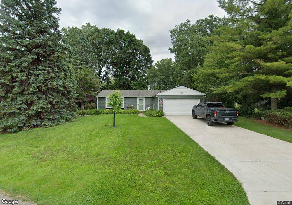
1739 Henbert Ct West Bloomfield, MI 48324
Estimated Value: $251,000 - $307,454
3
Beds
2
Baths
1,328
Sq Ft
$214/Sq Ft
Est. Value
About This Home
This home is located at 1739 Henbert Ct, West Bloomfield, MI 48324 and is currently estimated at $283,614, approximately $213 per square foot. 1739 Henbert Ct is a home located in Oakland County with nearby schools including Haviland Elementary School, Pierce Middle School, and Waterford Mott High School.
Ownership History
Date
Name
Owned For
Owner Type
Purchase Details
Closed on
Aug 21, 2018
Sold by
Garrison Michael and Estate Of Dorothy Garrison
Bought by
Garrison O Neill Suzanne and Neill Timothy O
Current Estimated Value
Purchase Details
Closed on
Jan 12, 2016
Sold by
Garrison James and Garrison James
Bought by
Shane O Neill and Neill Timothy O
Purchase Details
Closed on
Nov 5, 2001
Sold by
Garrison James and Garrison Dorothy
Bought by
Garrison Michael and Garrison Timothy
Create a Home Valuation Report for This Property
The Home Valuation Report is an in-depth analysis detailing your home's value as well as a comparison with similar homes in the area
Home Values in the Area
Average Home Value in this Area
Purchase History
| Date | Buyer | Sale Price | Title Company |
|---|---|---|---|
| Garrison O Neill Suzanne | $140,000 | None Available | |
| Shane O Neill | -- | None Available | |
| Garrison Michael | -- | None Available |
Source: Public Records
Tax History Compared to Growth
Tax History
| Year | Tax Paid | Tax Assessment Tax Assessment Total Assessment is a certain percentage of the fair market value that is determined by local assessors to be the total taxable value of land and additions on the property. | Land | Improvement |
|---|---|---|---|---|
| 2024 | $1,722 | $135,430 | $0 | $0 |
| 2022 | $1,643 | $127,470 | $36,000 | $91,470 |
| 2021 | $2,525 | $108,280 | $0 | $0 |
| 2020 | $1,504 | $103,480 | $26,570 | $76,910 |
| 2018 | $2,415 | $90,840 | $21,000 | $69,840 |
| 2015 | -- | $73,700 | $0 | $0 |
| 2014 | -- | $68,030 | $0 | $0 |
| 2011 | -- | $62,990 | $0 | $0 |
Source: Public Records
Map
Nearby Homes
- 1837 Henbert Rd
- 1811 Henbert Rd
- 1992 Swaranne Dr
- 6620 Red Cedar Ln Unit 37
- 1604 Petrolia
- 6726 Red Cedar Ln
- 1985 Christopher Ct
- VAC Mercedes Ave
- 1276 Jay St Unit 6
- VL Tamson St
- 2236 Locklin Ln
- 2112 Keylon Dr
- 1150 Jay St
- 9999 Cooley Lake Rd
- 1701 Marylestone Dr
- 7040 Villa Dr Unit 2
- 6034 Beachwood Dr
- 1644 Marylestone Dr
- 2140 Timberridge Ct
- 6057 Beachwood Dr
- 1777 Henbert Ct Unit Bldg-Unit
- 1777 Henbert Ct
- 1814 Henbert Rd
- 1721 Henbert Ct
- 1804 Henbert Rd
- 1720 Henbert Ct
- 1758 Henbert Ct
- 1738 Henbert Ct
- 1780 Henbert Ct
- 1750 Henbert Rd
- 1824 Henbert Ct
- 1734 Henbert Rd
- 1813 Henbert Rd
- 1827 Henbert Rd
- 1803 Henbert Rd
- 1836 Henbert Rd
- 1789 Henbert Rd
- 1775 Henbert Rd
- 1737 Lochaven Rd
- 1761 Henbert Rd