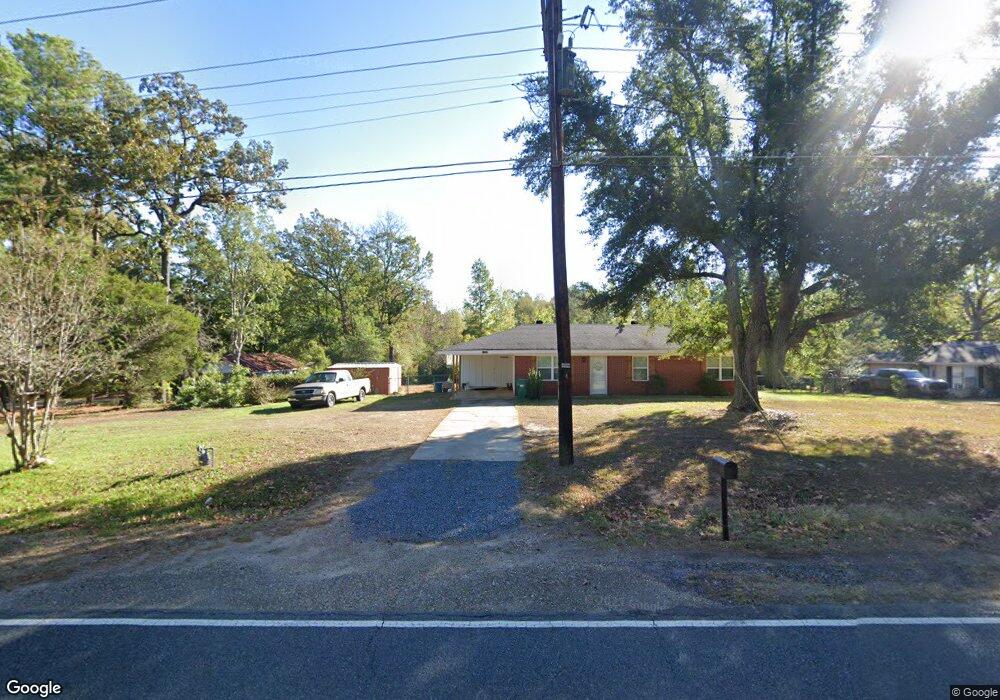
1739 Highway 557 West Monroe, LA 71292
Estimated Value: $110,000 - $195,000
3
Beds
1
Bath
--
Sq Ft
1.89
Acres
About This Home
This home is located at 1739 Highway 557, West Monroe, LA 71292 and is currently estimated at $146,698. 1739 Highway 557 is a home located in Ouachita Parish with nearby schools including Woodlawn Elementary School, Woodlawn Middle School, and West Ouachita High School.
Ownership History
Date
Name
Owned For
Owner Type
Purchase Details
Closed on
Mar 14, 2022
Sold by
Charles Bounds Zachary and Charles Marie Leanne
Bought by
J Ranch Properties Llc
Current Estimated Value
Home Financials for this Owner
Home Financials are based on the most recent Mortgage that was taken out on this home.
Original Mortgage
$50,000,000
Outstanding Balance
$46,463,892
Interest Rate
3.92%
Mortgage Type
Credit Line Revolving
Estimated Equity
-$46,317,194
Purchase Details
Closed on
Sep 29, 2017
Sold by
Carter Carolyn Self
Bought by
Bounds Zachary and Bounds Leanne
Home Financials for this Owner
Home Financials are based on the most recent Mortgage that was taken out on this home.
Original Mortgage
$68,686
Interest Rate
3.82%
Mortgage Type
New Conventional
Purchase Details
Closed on
Mar 29, 2017
Sold by
Deland Barbara Self
Bought by
Carter Carolyn Self
Create a Home Valuation Report for This Property
The Home Valuation Report is an in-depth analysis detailing your home's value as well as a comparison with similar homes in the area
Home Values in the Area
Average Home Value in this Area
Purchase History
| Date | Buyer | Sale Price | Title Company |
|---|---|---|---|
| J Ranch Properties Llc | $90,000 | Dimos Erskine Llp | |
| Bounds Zachary | $68,000 | North Delta Title | |
| Carter Carolyn Self | -- | None Available |
Source: Public Records
Mortgage History
| Date | Status | Borrower | Loan Amount |
|---|---|---|---|
| Open | J Ranch Properties Llc | $50,000,000 | |
| Previous Owner | Bounds Zachary | $68,686 |
Source: Public Records
Tax History Compared to Growth
Tax History
| Year | Tax Paid | Tax Assessment Tax Assessment Total Assessment is a certain percentage of the fair market value that is determined by local assessors to be the total taxable value of land and additions on the property. | Land | Improvement |
|---|---|---|---|---|
| 2024 | $965 | $10,579 | $2,268 | $8,311 |
| 2023 | $976 | $8,406 | $2,268 | $6,138 |
| 2022 | $750 | $8,406 | $2,268 | $6,138 |
| 2021 | $759 | $8,455 | $2,268 | $6,187 |
| 2020 | $759 | $8,455 | $2,268 | $6,187 |
| 2019 | $723 | $8,070 | $2,268 | $5,802 |
| 2018 | $51 | $8,071 | $2,268 | $5,803 |
| 2017 | $723 | $8,022 | $2,268 | $5,754 |
| 2016 | $579 | $4,050 | $1,000 | $3,050 |
| 2015 | $362 | $4,050 | $1,000 | $3,050 |
| 2014 | $362 | $4,050 | $1,000 | $3,050 |
| 2013 | $361 | $4,050 | $1,000 | $3,050 |
Source: Public Records
Map
Nearby Homes
- 00 Bay Leaf Dr
- 2164 Louisiana 557
- 146 S Leo Ln
- 111 Frost Tower Rd
- 175 S Leo Ln
- 184 S Leo Ln
- 212 S Leo Ln
- 000 Jimmy Graham Loop
- 000 William Harris Rd Unit 1.365 Acres
- 0 Roberson Rd Unit 206166
- 112 Bill Dr
- 2104 Red Cut Rd
- 0 Ed Rutledge Rd Unit 215652
- 1147 Frost Tower Rd
- 6347 Jonesboro Rd
- Red Cut Road Lot Unit Wp001
- 1198 Philpot Rd Unit 1196 Philpot Road
- 494 Lapine Rd
- 850 Lapine Rd
- 2017 Philpot Rd
- 1739 La-557
- 1751 Highway 557
- 1725 Highway 557
- 1765 Highway 557
- 1711 Highway 557
- 1779 Highway 557
- 1774 Highway 557
- 1661 Highway 557
- 150 Elliott Rd
- 133 Elliott Rd
- 133 Elliott Rd
- 1795 Highway 557
- 1795 Highway 557
- 1641 Highway 557
- 1641 Highway 557
- 108 Silverleaf Dr
- 106 Silverleaf Dr
- 147 Elliott Rd
- 1628 Highway 557
- 110 Silverleaf Trail