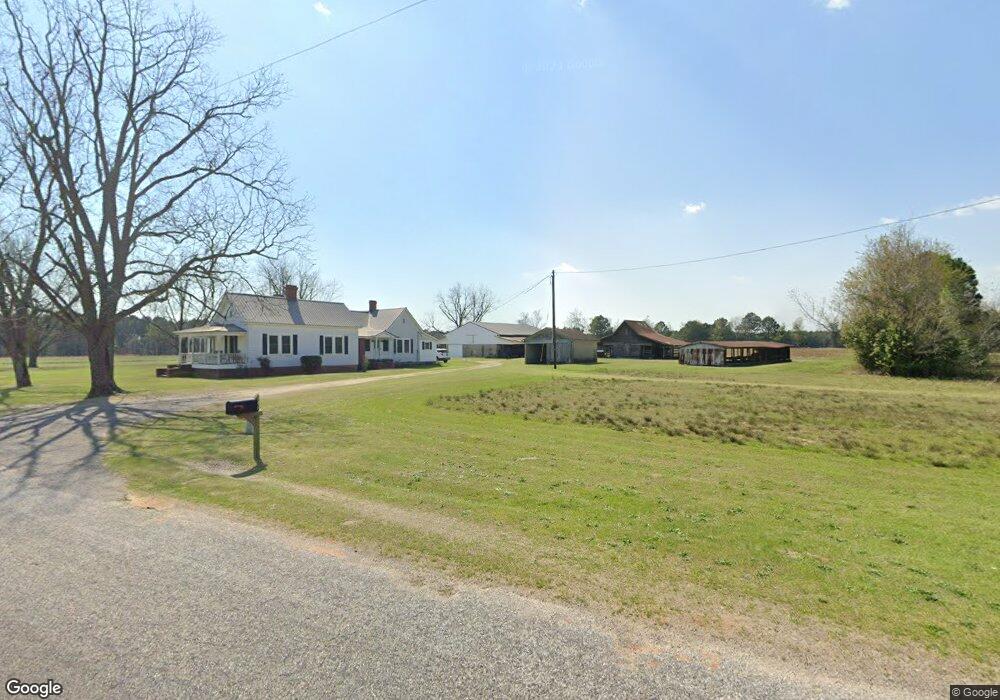
1739 Luke Bridge Rd Johnston, SC 29832
Estimated Value: $276,000 - $562,723
2
Beds
1
Bath
2,342
Sq Ft
$171/Sq Ft
Est. Value
About This Home
This home is located at 1739 Luke Bridge Rd, Johnston, SC 29832 and is currently estimated at $401,574, approximately $171 per square foot. 1739 Luke Bridge Rd is a home located in Edgefield County with nearby schools including Johnston Elementary School, Johnston-Edgefield-Trenton Middle School, and Strom Thurmond High School.
Ownership History
Date
Name
Owned For
Owner Type
Purchase Details
Closed on
Feb 3, 2012
Sold by
Holmes Wilbur Eugene and Holmes Deborah C
Bought by
Holmes Benjamin C and Holmes Jennifer A
Current Estimated Value
Purchase Details
Closed on
Sep 26, 2011
Sold by
Holmes Wilbur Eugene and Holmes Deborah C
Bought by
Brown Rebekah Holmes and Brown Anthony Rhoades
Create a Home Valuation Report for This Property
The Home Valuation Report is an in-depth analysis detailing your home's value as well as a comparison with similar homes in the area
Home Values in the Area
Average Home Value in this Area
Purchase History
| Date | Buyer | Sale Price | Title Company |
|---|---|---|---|
| Holmes Benjamin C | -- | -- | |
| Brown Rebekah Holmes | -- | -- |
Source: Public Records
Tax History
| Year | Tax Paid | Tax Assessment Tax Assessment Total Assessment is a certain percentage of the fair market value that is determined by local assessors to be the total taxable value of land and additions on the property. | Land | Improvement |
|---|---|---|---|---|
| 2025 | $477 | $3,840 | $710 | $3,130 |
| 2024 | $455 | $3,840 | $710 | $3,130 |
| 2023 | $455 | $3,840 | $710 | $3,130 |
| 2022 | $470 | $3,840 | $710 | $3,130 |
| 2021 | $573 | $4,040 | $710 | $3,330 |
| 2020 | $407 | $3,750 | $710 | $3,040 |
| 2019 | $541 | $3,750 | $710 | $3,040 |
| 2018 | $485 | $3,750 | $710 | $3,040 |
| 2017 | $455 | $3,750 | $710 | $3,040 |
| 2016 | $407 | $3,430 | $710 | $2,720 |
| 2013 | -- | $3,380 | $700 | $2,680 |
Source: Public Records
Map
Nearby Homes
- 0 Archie Ware Rd Unit 218976
- 81 State Highway S-19-313
- 000 Mile Bridge Way
- 97 Laurel Heights
- 000 Archie Ware Rd
- TBD Mt Calvary Rd
- Mount Calvary Rd
- 508 E Wise St
- 43 Aviary Ln
- 158 Traditions Dr
- 144 Traditions Dr
- 20 Blackberry Ln
- 846 Mason Branch Rd
- 1679 McCreight Rd
- 0 S Carolina 121 Unit 548610
- 125 Egghouse Rd
- Tbd Dogwood Ln
- 264 Willis Rd
- Lot A Sertoma Dr
- 00 Sertoma Dr
- 1785 Luke Bridge Rd Unit 1
- 1785 Luke Bridge Rd
- 6 Lott Rd
- 6 Lott Rd
- 10 Lott Rd
- 0 Luke Bridge Rd Unit 305487
- 0 Luke Bridge Rd Unit 65320
- 38 Lott Rd
- 1785 Lure Bridge Rd
- 34 Culver Ln
- 50 Lott Rd
- 42 Lott Rd
- 90 Lott Rd
- 6 Franklin Rd
- 1834 Luke Bridge Rd
- 3 Franklin Rd
- 1198 S Carolina 191
- 1198 Sc Highway 191
- 1260 Sc Highway 191
- 156 Hillyer Branch Rd
Your Personal Tour Guide
Ask me questions while you tour the home.