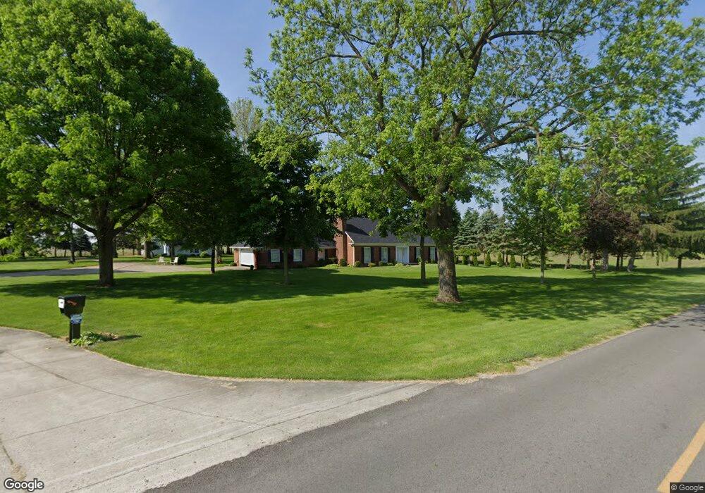
17391 King Rd Bowling Green, OH 43402
Estimated Value: $545,000 - $670,000
4
Beds
3
Baths
2,486
Sq Ft
$251/Sq Ft
Est. Value
About This Home
This home is located at 17391 King Rd, Bowling Green, OH 43402 and is currently estimated at $623,671, approximately $250 per square foot. 17391 King Rd is a home located in Wood County with nearby schools including Otsego Elementary School, Otsego Junior High School, and Otsego High School.
Ownership History
Date
Name
Owned For
Owner Type
Purchase Details
Closed on
Jan 29, 2020
Sold by
Behnfeldt Virgil E and Behnfeldt Melva Jean
Bought by
Behnfeldt Virgil E and Behnfeldt Melva Jean
Current Estimated Value
Purchase Details
Closed on
May 3, 2018
Sold by
Behnfkedt Virgil E and Behnfkedt Melva Jean
Bought by
Behnfeldt Virgil E and Behnfeldt Melva Jean
Purchase Details
Closed on
Feb 6, 2014
Sold by
Behnfeldt Virgil E and Behnfeldt Melva Jean
Bought by
The Behnfeldt Family 2015 Trust and Behnfeldt Melva Jean
Purchase Details
Closed on
Aug 30, 2012
Sold by
Behnfeldt Virgil E and Behnfeldt Melva Jean
Bought by
Behnfeldt Virgil E and Behnfeldt Melva Jean
Purchase Details
Closed on
Apr 26, 1993
Bought by
Behnfeldt Virgil E
Create a Home Valuation Report for This Property
The Home Valuation Report is an in-depth analysis detailing your home's value as well as a comparison with similar homes in the area
Home Values in the Area
Average Home Value in this Area
Purchase History
| Date | Buyer | Sale Price | Title Company |
|---|---|---|---|
| Behnfeldt Virgil E | -- | None Available | |
| Behnfeldt Virgil E | -- | None Available | |
| The Behnfeldt Family 2015 Trust | -- | None Available | |
| Behnfeldt Virgil E | -- | None Available | |
| Behnfeldt Virgil E | -- | -- |
Source: Public Records
Tax History Compared to Growth
Tax History
| Year | Tax Paid | Tax Assessment Tax Assessment Total Assessment is a certain percentage of the fair market value that is determined by local assessors to be the total taxable value of land and additions on the property. | Land | Improvement |
|---|---|---|---|---|
| 2024 | $5,386 | $171,850 | $70,875 | $100,975 |
| 2023 | $5,386 | $171,860 | $70,880 | $100,980 |
| 2021 | $4,491 | $142,070 | $57,370 | $84,700 |
| 2020 | $4,515 | $142,070 | $57,370 | $84,700 |
| 2019 | $4,426 | $120,930 | $49,740 | $71,190 |
| 2018 | $4,439 | $120,930 | $49,740 | $71,190 |
| 2017 | $4,341 | $120,930 | $49,740 | $71,190 |
| 2016 | $4,218 | $103,110 | $38,710 | $64,400 |
| 2015 | $4,218 | $103,110 | $38,710 | $64,400 |
| 2014 | $4,353 | $103,110 | $38,710 | $64,400 |
| 2013 | $4,005 | $98,040 | $33,640 | $64,400 |
Source: Public Records
Map
Nearby Homes
- 16890 W River Rd
- 0 River Rd W
- 335 S River Rd
- 109 High St
- 320 Ridgepoint Cir
- 21 Pennsylvania Ave
- 1248 Applegate St
- 35 S River Rd
- 1371 Eastridge Dr
- 132 Wilkshire Dr
- 0 Noward Rd
- 513 North St
- 1314 Limerick Ln
- 1324 Limerick Ln
- 1304 Limerick Ln
- 1407 Thomas Ln
- 1396 Thomas Ln
- 8720 Waterville Swanton Rd
- 131 N River Rd
- 214 N 2nd St
- 17480 King Rd
- 17575 King Rd
- 17564 King Rd
- 17617 W River Rd
- 17612 W River Rd
- 17615 W River Rd
- 1 W River Rd
- 17000 W River Rd
- 17593 W River Rd
- 17599 W River Rd
- 17522 W River Rd
- 17643 W River Rd
- 17659 W River Rd
- 17608 W River Rd
- 17552 W River Rd
- 17551 W River Rd
- 17630 W River Rd
- 17126 King Rd
- 17640 W River Rd
- 17088 King Rd