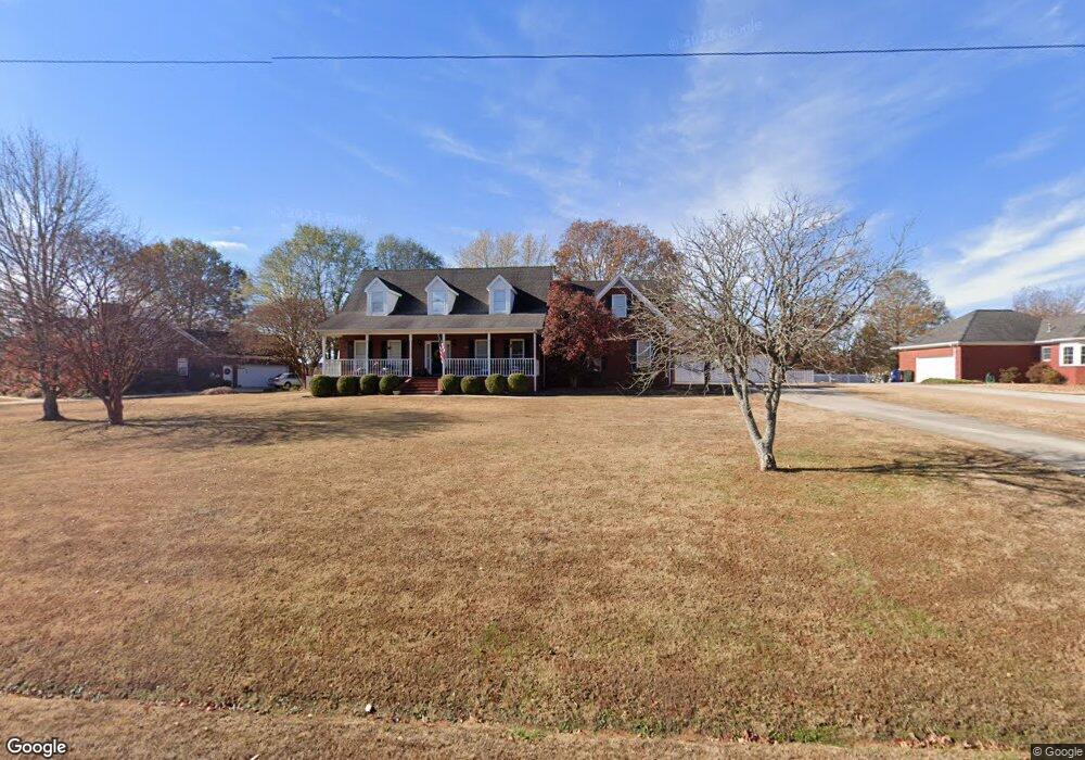
174 Dupree Dr Huntsville, AL 35806
Monrovia NeighborhoodEstimated Value: $379,113 - $441,000
--
Bed
1
Bath
2,394
Sq Ft
$169/Sq Ft
Est. Value
About This Home
This home is located at 174 Dupree Dr, Huntsville, AL 35806 and is currently estimated at $404,778, approximately $169 per square foot. 174 Dupree Dr is a home with nearby schools including Legacy Elementary School, Monrovia Middle School, and Sparkman High School.
Ownership History
Date
Name
Owned For
Owner Type
Purchase Details
Closed on
Jul 28, 2025
Sold by
Rountree Doris A and Rountree James W
Bought by
Rountree Living Trust and Rountree
Current Estimated Value
Purchase Details
Closed on
Apr 16, 2024
Sold by
Rountree Living Trust and Rountree James W
Bought by
Rountree Doris A and Rountree James W
Create a Home Valuation Report for This Property
The Home Valuation Report is an in-depth analysis detailing your home's value as well as a comparison with similar homes in the area
Home Values in the Area
Average Home Value in this Area
Purchase History
| Date | Buyer | Sale Price | Title Company |
|---|---|---|---|
| Rountree Living Trust | $343,500 | None Listed On Document | |
| Rountree Living Trust | $343,500 | None Listed On Document | |
| Rountree Doris A | $332,000 | None Listed On Document | |
| Rountree Doris A | $332,000 | None Listed On Document |
Source: Public Records
Tax History Compared to Growth
Tax History
| Year | Tax Paid | Tax Assessment Tax Assessment Total Assessment is a certain percentage of the fair market value that is determined by local assessors to be the total taxable value of land and additions on the property. | Land | Improvement |
|---|---|---|---|---|
| 2024 | $1,157 | $33,200 | $2,340 | $30,860 |
| 2023 | $1,157 | $32,100 | $2,340 | $29,760 |
| 2022 | $967 | $27,940 | $1,500 | $26,440 |
| 2021 | $899 | $26,080 | $1,500 | $24,580 |
| 2020 | $839 | $24,410 | $1,490 | $22,920 |
| 2019 | $802 | $23,380 | $1,490 | $21,890 |
| 2018 | $755 | $22,120 | $0 | $0 |
| 2017 | $755 | $22,120 | $0 | $0 |
| 2016 | $755 | $22,120 | $0 | $0 |
| 2015 | $755 | $22,120 | $0 | $0 |
| 2014 | $761 | $22,260 | $0 | $0 |
Source: Public Records
Map
Nearby Homes
- 109 Sarah Jane Dr
- 124 Huston Ct
- 104 Raymon Cir
- 1.4 acres Jeff Rd NW
- 10.4 acres Jeff Rd NW
- 1 ACRE EASEMENT Jeff Rd NW
- 436 Mount Zion Rd
- 2031 Blake Bottom Rd NW Unit 15
- 2031 Blake Bottom Rd NW
- 2031 Blake Bottom Rd NW Unit 2
- 989 Jeff Rd NW
- 482 Mount Zion Rd
- 229 Brooklet Ct
- 253 Pumprock Dr
- 223 Wainscott Dr
- 108 Conifer Ct
- 150 Blue Spruce Dr
- 114 Pettus Rd
- 115 Misty Hollow Way
- 195 Sarah Jane Dr