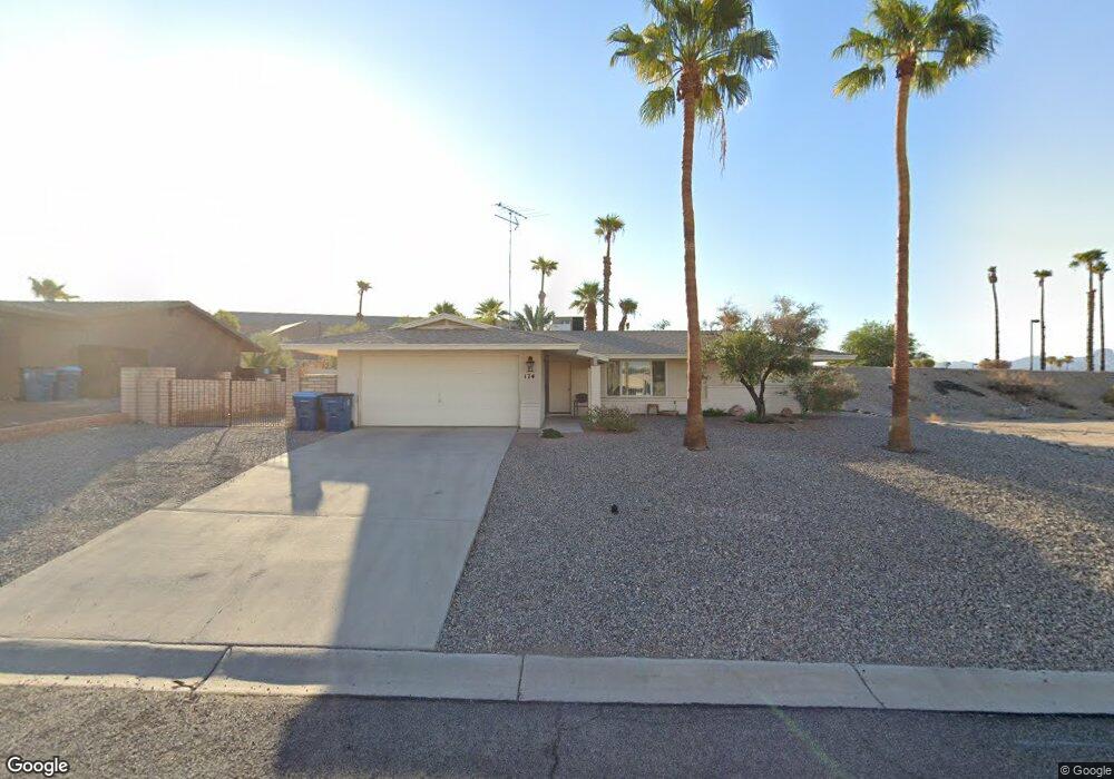
174 Greentree Dr Lake Havasu City, AZ 86403
Estimated Value: $297,000 - $456,000
--
Bed
1
Bath
1,500
Sq Ft
$234/Sq Ft
Est. Value
About This Home
This home is located at 174 Greentree Dr, Lake Havasu City, AZ 86403 and is currently estimated at $350,488, approximately $233 per square foot. 174 Greentree Dr is a home located in Mohave County with nearby schools including Starline Elementary School, Thunderbolt Middle School, and Lake Havasu High School.
Ownership History
Date
Name
Owned For
Owner Type
Purchase Details
Closed on
Jan 6, 2023
Sold by
Our Lady Of The Lake Roman Catholic Pari
Bought by
Our Lady Of The Lake Roman Catholic Parish La
Current Estimated Value
Purchase Details
Closed on
Dec 4, 2013
Sold by
Studer Conrad A
Bought by
Our Lady Of The Lake Roman Catholic Pari
Purchase Details
Closed on
Apr 22, 2002
Sold by
Studer Conrad A
Bought by
Studer Conrad Albert
Purchase Details
Closed on
Aug 23, 2000
Sold by
Firstar Bank Na
Bought by
Studer Conrad A and Studer Linda P
Create a Home Valuation Report for This Property
The Home Valuation Report is an in-depth analysis detailing your home's value as well as a comparison with similar homes in the area
Home Values in the Area
Average Home Value in this Area
Purchase History
| Date | Buyer | Sale Price | Title Company |
|---|---|---|---|
| Our Lady Of The Lake Roman Catholic Parish La | -- | -- | |
| Our Lady Of The Lake Roman Catholic Pari | -- | None Available | |
| Studer Conrad Albert | -- | -- | |
| Studer Conrad A | $70,000 | First American Title |
Source: Public Records
Tax History Compared to Growth
Tax History
| Year | Tax Paid | Tax Assessment Tax Assessment Total Assessment is a certain percentage of the fair market value that is determined by local assessors to be the total taxable value of land and additions on the property. | Land | Improvement |
|---|---|---|---|---|
| 2026 | $545 | -- | -- | -- |
| 2025 | $545 | $21,377 | $0 | $0 |
| 2024 | $545 | $34,572 | $0 | $0 |
| 2023 | $0 | $23,349 | $0 | $0 |
| 2022 | $585 | $21,183 | $0 | $0 |
| 2021 | $585 | $17,725 | $0 | $0 |
| 2019 | $0 | $14,652 | $0 | $0 |
| 2018 | $0 | $14,543 | $0 | $0 |
| 2017 | $1,111 | $13,558 | $0 | $0 |
| 2016 | $1,011 | $11,793 | $0 | $0 |
| 2015 | $971 | $10,942 | $0 | $0 |
Source: Public Records
Map
Nearby Homes
- 160 Aspen Dr
- 190 Aspen Dr
- 371 Cottonwood Dr
- 2080 Swanson Ave Unit F
- 2080 Swanson Ave Unit C
- 2080 Swanson Ave Unit D
- 2080 Swanson Ave Unit I
- 100 Mulberry Ave Unit 210
- 100 Mulberry Ave Unit 113
- 1958 Montana Vista Unit D
- 2042 Swanson Ave Unit A
- 2042 Swanson Ave Unit H
- 72 Mariposa Dr Unit D
- 1962 Cliffrose Dr
- 2121 Magnolia Dr Unit 16
- 2121 Magnolia Dr Unit 1
- 1827 Combat Dr
- 1852 Montana Vista Unit B
- 1939 Pine Ln
- 1884 Montana Vista Unit 63B