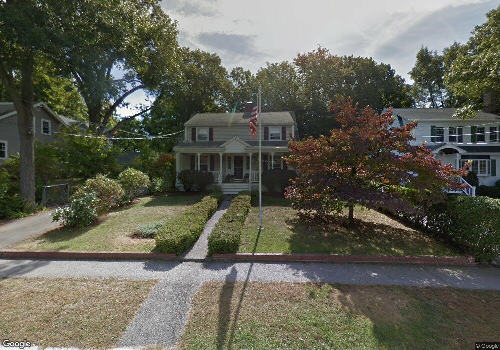
174 Hollis Ave Braintree, MA 02184
North Braintree NeighborhoodEstimated Value: $896,888 - $1,001,000
4
Beds
2
Baths
2,460
Sq Ft
$394/Sq Ft
Est. Value
About This Home
This home is located at 174 Hollis Ave, Braintree, MA 02184 and is currently estimated at $968,472, approximately $393 per square foot. 174 Hollis Ave is a home located in Norfolk County with nearby schools including Braintree High School, Step Ahead Kindergarten, and Meeting House Montessori School.
Ownership History
Date
Name
Owned For
Owner Type
Purchase Details
Closed on
May 23, 2002
Sold by
Hultstrom Roland E
Bought by
Harrington Edward P and Harrington Sarah M
Current Estimated Value
Home Financials for this Owner
Home Financials are based on the most recent Mortgage that was taken out on this home.
Original Mortgage
$220,000
Outstanding Balance
$93,420
Interest Rate
7.01%
Mortgage Type
Purchase Money Mortgage
Estimated Equity
$875,052
Create a Home Valuation Report for This Property
The Home Valuation Report is an in-depth analysis detailing your home's value as well as a comparison with similar homes in the area
Home Values in the Area
Average Home Value in this Area
Purchase History
| Date | Buyer | Sale Price | Title Company |
|---|---|---|---|
| Harrington Edward P | $425,000 | -- |
Source: Public Records
Mortgage History
| Date | Status | Borrower | Loan Amount |
|---|---|---|---|
| Open | Harrington Edward P | $220,000 |
Source: Public Records
Tax History
| Year | Tax Paid | Tax Assessment Tax Assessment Total Assessment is a certain percentage of the fair market value that is determined by local assessors to be the total taxable value of land and additions on the property. | Land | Improvement |
|---|---|---|---|---|
| 2025 | $8,140 | $815,600 | $414,600 | $401,000 |
| 2024 | $7,264 | $766,200 | $370,200 | $396,000 |
| 2023 | $6,930 | $710,000 | $335,600 | $374,400 |
| 2022 | $6,671 | $670,500 | $296,100 | $374,400 |
| 2021 | $6,349 | $638,100 | $296,100 | $342,000 |
| 2020 | $5,942 | $602,600 | $260,600 | $342,000 |
| 2019 | $5,820 | $576,800 | $260,600 | $316,200 |
| 2018 | $5,693 | $540,100 | $236,900 | $303,200 |
| 2017 | $5,662 | $527,200 | $236,900 | $290,300 |
| 2016 | $5,434 | $494,900 | $213,200 | $281,700 |
| 2015 | $5,335 | $481,900 | $213,200 | $268,700 |
| 2014 | $4,840 | $423,800 | $176,700 | $247,100 |
Source: Public Records
Map
Nearby Homes
- 87 Walnut St
- 491 Washington St Unit 1
- 469-471 Washington St
- 63 Dickerman Ln
- 29 Joseph Rd
- 5 Woodsum Dr Unit 12
- 15 Calvin St
- 20 Vine St
- 7 Del's Way
- 47 Addison St
- 20 Blossom Rd
- 50 Cleveland Ave
- 36 Chestnut Ave
- 18 Royal Lake Dr Unit 3
- 255 River St
- 342 Elm St
- 9 Independence Ave Unit 307
- 6 Franklin St
- 17 White Rd
- 192 Federal Ave Unit B
- 184 Hollis Ave
- 168 Hollis Ave
- 166 Hollis Ave
- 192 Hollis Ave
- 125 Monatiquot Ave
- 119 Monatiquot Ave
- 164 Hollis Ave
- 169 Hollis Ave
- 185 Hollis Ave
- 167 Hollis Ave
- 189 Hollis Ave
- 165 Hollis Ave
- 115 Monatiquot Ave
- 156 Hollis Ave
- 195 Hollis Ave
- 43 Walnut St
- 159 Hollis Ave
- 135 Monatiquot Ave
- 50 Oak St
- 32 Judson St
Your Personal Tour Guide
Ask me questions while you tour the home.