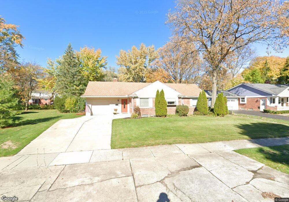
17400 Birwood Ave Beverly Hills, MI 48025
Estimated Value: $488,000 - $540,000
3
Beds
2
Baths
1,450
Sq Ft
$346/Sq Ft
Est. Value
About This Home
This home is located at 17400 Birwood Ave, Beverly Hills, MI 48025 and is currently estimated at $501,993, approximately $346 per square foot. 17400 Birwood Ave is a home located in Oakland County with nearby schools including Beverly Elementary School, Wylie E. Groves High School, and Berkshire Middle School.
Ownership History
Date
Name
Owned For
Owner Type
Purchase Details
Closed on
Jun 2, 2017
Sold by
Cesnik Catherine L K
Bought by
Kozak Robert and Kozak Catherine A
Current Estimated Value
Home Financials for this Owner
Home Financials are based on the most recent Mortgage that was taken out on this home.
Original Mortgage
$224,000
Interest Rate
4.03%
Mortgage Type
New Conventional
Purchase Details
Closed on
Jun 9, 2015
Sold by
Kozak Nicholas J and Kozak Kori N
Bought by
Cesnik Catherine L K
Purchase Details
Closed on
May 22, 2007
Sold by
Leon Dino A and Leon Dino
Bought by
Washington Mutual Bank and Washington Mutual Bank Fa
Purchase Details
Closed on
Feb 11, 2002
Sold by
Bader Henrietta
Bought by
Leon Dino A
Home Financials for this Owner
Home Financials are based on the most recent Mortgage that was taken out on this home.
Original Mortgage
$186,300
Interest Rate
6.92%
Create a Home Valuation Report for This Property
The Home Valuation Report is an in-depth analysis detailing your home's value as well as a comparison with similar homes in the area
Home Values in the Area
Average Home Value in this Area
Purchase History
| Date | Buyer | Sale Price | Title Company |
|---|---|---|---|
| Kozak Robert | $300,000 | None Available | |
| Cesnik Catherine L K | $296,000 | Fidelity Natl Title Co Llc | |
| Washington Mutual Bank | $252,361 | None Available | |
| Leon Dino A | $207,000 | -- |
Source: Public Records
Mortgage History
| Date | Status | Borrower | Loan Amount |
|---|---|---|---|
| Previous Owner | Kozak Robert | $224,000 | |
| Previous Owner | Leon Dino A | $186,300 |
Source: Public Records
Tax History Compared to Growth
Tax History
| Year | Tax Paid | Tax Assessment Tax Assessment Total Assessment is a certain percentage of the fair market value that is determined by local assessors to be the total taxable value of land and additions on the property. | Land | Improvement |
|---|---|---|---|---|
| 2024 | $7,277 | $196,570 | $0 | $0 |
| 2023 | $6,953 | $181,100 | $0 | $0 |
| 2022 | $8,445 | $171,500 | $0 | $0 |
| 2021 | $8,233 | $164,270 | $0 | $0 |
| 2020 | $6,201 | $157,270 | $0 | $0 |
| 2019 | $5,872 | $151,110 | $0 | $0 |
| 2018 | $7,813 | $144,210 | $0 | $0 |
| 2017 | $7,048 | $144,210 | $0 | $0 |
| 2016 | $7,226 | $134,420 | $0 | $0 |
| 2015 | -- | $111,160 | $0 | $0 |
| 2014 | -- | $99,170 | $0 | $0 |
| 2011 | -- | $86,540 | $0 | $0 |
Source: Public Records
Map
Nearby Homes
- 16975 W Fourteen Mile Rd
- 1748 Stanley Blvd
- 1850 Shipman Blvd
- 1723 Birmingham Blvd
- 1886 Henrietta St
- 955 Wakefield St
- 1626 Maryland Blvd
- 16950 Kinross Ave
- 150 Bird Ave Unit 20
- 16281 Buckingham Ave
- 1541 Shipman Blvd
- 251 E 14 Mile Rd
- 1130 Wakefield St
- 1897 Norfolk St
- 1419 Henrietta St
- 350 Catalpa Dr
- 1380 Pierce St
- 1485 Cedar Dr
- 15858 Kirkshire Ave
- 1053 Canterbury St
- 17450 Birwood Ave
- 17360 Birwood Ave
- 17425 Kirkshire Ave
- 17381 Kirkshire Ave
- 17465 Kirkshire Ave
- 17330 Birwood Ave
- 17500 Birwood Ave
- 17441 Birwood Ave
- 17451 Birwood Ave
- 17335 Kirkshire Ave
- 17375 Birwood Ave
- 17503 Kirkshire Ave
- 17300 Birwood Ave
- 17450 Buckingham Ave
- 17333 Birwood Ave
- 17501 Birwood Ave
- 17540 Birwood Ave
- 17560 Birwood Ave
- 17301 Birwood Ave
- 17430 Kirkshire Ave