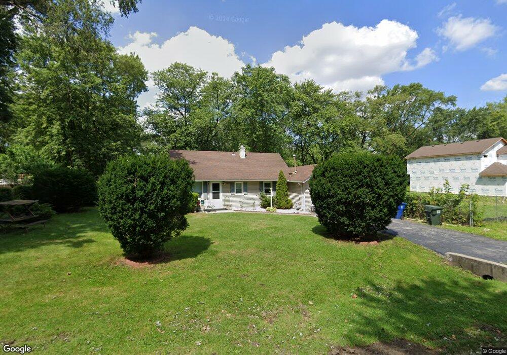
17406 Loomis Ave Hazel Crest, IL 60429
Estimated Value: $101,000 - $150,000
2
Beds
1
Bath
600
Sq Ft
$196/Sq Ft
Est. Value
About This Home
This home is located at 17406 Loomis Ave, Hazel Crest, IL 60429 and is currently estimated at $117,622, approximately $196 per square foot. 17406 Loomis Ave is a home located in Cook County with nearby schools including Thornwood High School.
Ownership History
Date
Name
Owned For
Owner Type
Purchase Details
Closed on
Apr 14, 2007
Sold by
Palos Bank & Trust Co
Bought by
Plascencia Manuel H
Current Estimated Value
Home Financials for this Owner
Home Financials are based on the most recent Mortgage that was taken out on this home.
Original Mortgage
$71,000
Outstanding Balance
$42,571
Interest Rate
6.27%
Mortgage Type
Seller Take Back
Estimated Equity
$75,051
Purchase Details
Closed on
Nov 9, 2005
Sold by
Hunt David T
Bought by
Palos Bank & Trust Co and Trust #1-6620
Create a Home Valuation Report for This Property
The Home Valuation Report is an in-depth analysis detailing your home's value as well as a comparison with similar homes in the area
Home Values in the Area
Average Home Value in this Area
Purchase History
We collect this data history from publicly available records. To have your information removed, we recommend requesting removal directly through your county’s website.
| Date | Buyer | Sale Price | Title Company |
|---|---|---|---|
| Plascencia Manuel H | $71,000 | Cti | |
| Palos Bank & Trust Co | -- | -- |
Source: Public Records
Mortgage History
We collect this data history from publicly available records. To have your information removed, we recommend requesting removal directly through your county’s website.
| Date | Status | Borrower | Loan Amount |
|---|---|---|---|
| Open | Plascencia Manuel H | $71,000 |
Source: Public Records
Tax History
| Year | Tax Paid | Tax Assessment Tax Assessment Total Assessment is a certain percentage of the fair market value that is determined by local assessors to be the total taxable value of land and additions on the property. | Land | Improvement |
|---|---|---|---|---|
| 2025 | $2,018 | $7,200 | $2,008 | $5,192 |
| 2024 | $2,018 | $7,200 | $2,008 | $5,192 |
| 2023 | $729 | $7,200 | $2,008 | $5,192 |
| 2022 | $729 | $4,542 | $2,678 | $1,864 |
| 2021 | $773 | $4,541 | $2,677 | $1,864 |
| 2020 | $881 | $4,541 | $2,677 | $1,864 |
| 2019 | $1,114 | $5,293 | $2,454 | $2,839 |
| 2018 | $1,099 | $5,293 | $2,454 | $2,839 |
| 2017 | $1,140 | $5,293 | $2,454 | $2,839 |
| 2016 | $1,311 | $4,833 | $2,231 | $2,602 |
| 2015 | $1,199 | $4,833 | $2,231 | $2,602 |
| 2014 | $1,205 | $4,833 | $2,231 | $2,602 |
| 2013 | $1,885 | $6,466 | $2,231 | $4,235 |
Source: Public Records
Map
Nearby Homes
- 1401 174th St
- 1307 173rd St
- 1218 174th St
- 17208 Loomis Ave
- 1409 172nd St
- 1411 172nd St
- 1016 174th St
- 1021 173rd St
- 1113 171st St
- 17926 La Haigh Rd
- 17915 Hood Ave
- 17212 Hawthorne Dr
- 904 Garden Ln Unit 904
- 1812 Cedar Rd
- 17917 Ashland Ave
- 1624 Burr Oak Rd
- 17322 Forestway Dr
- 1415 Burr Oak Rd
- 1525 Burr Oak Rd
- 17092 Jodave Ave
- 17412 Loomis Ave
- 1409 174th St
- 17407 Loomis Ave
- 17403 Loomis Ave
- 17411 Loomis Ave
- 17419 Loomis Ave
- 17421 Loomis Ave
- 1321 174th St
- 1328 174th St
- 17425 Loomis Ave Unit 2
- 1402 174th St
- 1322 175th St
- 17429 Loomis Ave
- 1408 174th St
- 1315 174th St
- 1414 174th St
- 17323 Loomis Ave
- 1329 174th St
- 1412 174th St
- 1316 175th St
Your Personal Tour Guide
Ask me questions while you tour the home.