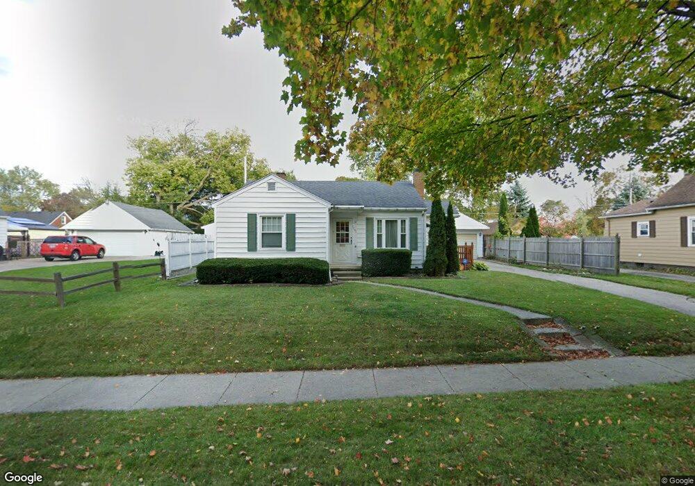
1741 Pattengill Ave Lansing, MI 48910
Quentin Park NeighborhoodEstimated Value: $137,927 - $153,000
--
Bed
1
Bath
889
Sq Ft
$165/Sq Ft
Est. Value
About This Home
This home is located at 1741 Pattengill Ave, Lansing, MI 48910 and is currently estimated at $146,982, approximately $165 per square foot. 1741 Pattengill Ave is a home located in Ingham County with nearby schools including Averill Elementary School, Pattengill Academy, and J.W. Sexton High School.
Ownership History
Date
Name
Owned For
Owner Type
Purchase Details
Closed on
Mar 20, 2025
Sold by
Blonde Ellen M
Bought by
Ellen M Blonde Trust and Blonde
Current Estimated Value
Purchase Details
Closed on
Sep 12, 1996
Sold by
Bondarenko Nena O
Bought by
Blonde Ellen M
Purchase Details
Closed on
Jul 12, 1996
Sold by
Kazmirzack David and Kazmirzack Kristine
Bought by
Bondarenko Nena O
Create a Home Valuation Report for This Property
The Home Valuation Report is an in-depth analysis detailing your home's value as well as a comparison with similar homes in the area
Home Values in the Area
Average Home Value in this Area
Purchase History
| Date | Buyer | Sale Price | Title Company |
|---|---|---|---|
| Ellen M Blonde Trust | -- | None Listed On Document | |
| Blonde Ellen M | $77,000 | -- | |
| Bondarenko Nena O | $78,500 | -- |
Source: Public Records
Tax History Compared to Growth
Tax History
| Year | Tax Paid | Tax Assessment Tax Assessment Total Assessment is a certain percentage of the fair market value that is determined by local assessors to be the total taxable value of land and additions on the property. | Land | Improvement |
|---|---|---|---|---|
| 2025 | $3,044 | $63,000 | $9,700 | $53,300 |
| 2024 | $24 | $60,600 | $9,700 | $50,900 |
| 2023 | $2,854 | $55,000 | $9,700 | $45,300 |
| 2022 | $2,573 | $50,600 | $9,700 | $40,900 |
| 2021 | $2,520 | $48,800 | $9,400 | $39,400 |
| 2020 | $2,504 | $46,600 | $9,400 | $37,200 |
| 2019 | $2,401 | $42,100 | $9,400 | $32,700 |
| 2018 | $2,250 | $40,900 | $9,400 | $31,500 |
| 2017 | $2,154 | $40,900 | $9,400 | $31,500 |
| 2016 | $2,060 | $38,300 | $9,400 | $28,900 |
| 2015 | $2,060 | $37,300 | $18,883 | $18,417 |
| 2014 | $2,060 | $36,500 | $18,883 | $17,617 |
Source: Public Records
Map
Nearby Homes
- 1315 Goodrich St
- 1312 W Mount Hope Ave
- 1309 Hammond St
- 1116 George St
- 1114 Goodrich St
- 1740 Wellington Rd Unit 103
- 1420 Poxson Ave
- 1120 Alsdorf St
- 2118 Marion Ave
- 1010 W Barnes Ave
- 2001 S Martin Luther King Junior Blvd
- 2011 S Martin Luther King jr Blvd
- 917 W Barnes Ave
- 1221 Moores River Dr
- 1913 Stirling Ave
- 2112 Stirling Ave
- 907 Lenore Ave
- 1516 Moores River Dr
- 1404 Kelsey Ave
- 1120 Kelsey Ave
- 1735 Pattengill Ave
- 1747 Pattengill Ave
- 1740 Park Ave
- 1734 Park Ave
- 1800 Park Ave
- 1729 Pattengill Ave
- 1803 Pattengill Ave
- 1804 Park Ave
- 1724 Park Ave
- 1736 Pattengill Ave
- 1723 Pattengill Ave
- 1742 Pattengill Ave
- 1732 Pattengill Ave
- 1746 Pattengill Ave
- 1728 Pattengill Ave
- 1813 Pattengill Ave
- 1720 Park Ave
- 1812 Park Ave