Estimated Value: $602,967 - $762,000
4
Beds
3
Baths
2,708
Sq Ft
$245/Sq Ft
Est. Value
About This Home
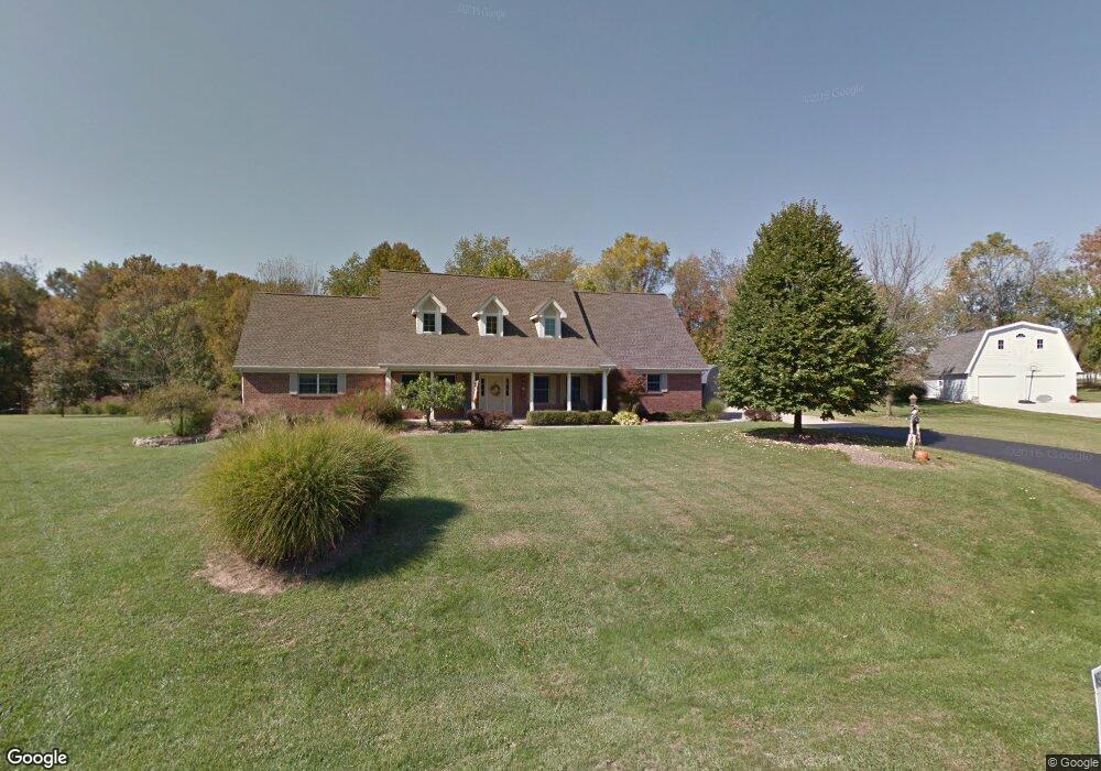
This home is located at 1741 Sutts Trail, Xenia, OH 45385 and is currently estimated at $662,242, approximately $244 per square foot. 1741 Sutts Trail is a home located in Greene County with nearby schools including Xenia High School.
Ownership History
Date
Name
Owned For
Owner Type
Purchase Details
Closed on
Jun 8, 2015
Sold by
Stockholm Robert G and Stockholm Teresa A
Bought by
Backhaus Stephen and Backhaus Rosemarie
Current Estimated Value
Home Financials for this Owner
Home Financials are based on the most recent Mortgage that was taken out on this home.
Original Mortgage
$303,905
Interest Rate
0.78%
Mortgage Type
New Conventional
Create a Home Valuation Report for This Property
The Home Valuation Report is an in-depth analysis detailing your home's value as well as a comparison with similar homes in the area
Home Values in the Area
Average Home Value in this Area
Purchase History
| Date | Buyer | Sale Price | Title Company |
|---|---|---|---|
| Backhaus Stephen | $319,900 | Attorney |
Source: Public Records
Mortgage History
| Date | Status | Borrower | Loan Amount |
|---|---|---|---|
| Previous Owner | Backhaus Stephen | $303,905 |
Source: Public Records
Tax History Compared to Growth
Tax History
| Year | Tax Paid | Tax Assessment Tax Assessment Total Assessment is a certain percentage of the fair market value that is determined by local assessors to be the total taxable value of land and additions on the property. | Land | Improvement |
|---|---|---|---|---|
| 2024 | $8,293 | $162,820 | $23,450 | $139,370 |
| 2023 | $8,293 | $162,820 | $23,450 | $139,370 |
| 2022 | $7,299 | $123,750 | $21,990 | $101,760 |
| 2021 | $7,387 | $123,750 | $21,990 | $101,760 |
| 2020 | $6,781 | $123,750 | $21,990 | $101,760 |
| 2019 | $6,123 | $99,710 | $18,780 | $80,930 |
| 2018 | $5,751 | $99,790 | $18,780 | $81,010 |
| 2017 | $5,135 | $99,790 | $18,780 | $81,010 |
| 2016 | $5,136 | $90,880 | $18,080 | $72,800 |
| 2015 | $5,019 | $90,880 | $18,080 | $72,800 |
| 2014 | $2,408 | $90,880 | $18,080 | $72,800 |
Source: Public Records
Map
Nearby Homes
- 1591 Valley Heights Rd
- 1753 Cedar Ridge Dr
- 2185 Tanbark Trail
- 2230 Little Miami Dr
- 2995 Upper Bellbrook Rd
- 102 Water St
- 1711 Mcclellan Rd
- 1061 Mcpherson Rd
- 1474 Hawkshead St
- 2018 Amberwood Ct
- Henley Plan at Edenbridge
- Holcombe Plan at Edenbridge
- Newcastle Plan at Edenbridge
- Bellamy Plan at Edenbridge
- Chatham Plan at Edenbridge
- 1272 Baybury Ave
- 1292 Baybury Ave
- 1293 Baybury Ave
- 1068 Hedges Rd
- 3509 Marwood Dr
- 1729 Sutts Trail
- 1746 Sutts Trail
- 1719 Sutts Trail
- 2291 Sieber Trace
- 1736 Sutts Trail
- 2313 Sieber Trace
- 1714 Sutts Trail
- 2249 Sieber Trace
- 1726 Sutts Trail
- 2350 Spahr Rd
- 2329 Sieber Trace
- 2332 Spahr Rd
- 1710 Sutts Trail
- 1680 Apache Trail
- 2304 Spahr Rd
- 1692 Apache Trail
- 2356 Spahr Rd
- 2356 Spahr Rd
- 1668 Apache Trail
- 1704 Sutts Trail