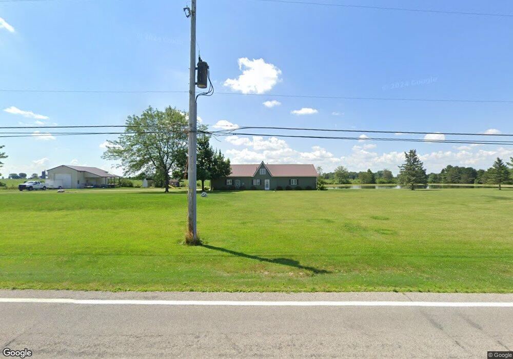
17425 State Route 2 Wauseon, OH 43567
Estimated Value: $265,000 - $331,000
2
Beds
2
Baths
1,440
Sq Ft
$210/Sq Ft
Est. Value
About This Home
This home is located at 17425 State Route 2, Wauseon, OH 43567 and is currently estimated at $302,000, approximately $209 per square foot. 17425 State Route 2 is a home with nearby schools including Pettisville Elementary School, Pettisville High School, and New Horizons Academy at Sara's Garden.
Ownership History
Date
Name
Owned For
Owner Type
Purchase Details
Closed on
Jan 9, 2024
Sold by
Knierim Kevin R and Knierim Janet P
Bought by
Kevin R Knierim And Janet P Knierim Joint Rev and Knierim
Current Estimated Value
Purchase Details
Closed on
Aug 24, 2012
Sold by
Miller Irene
Bought by
Knierim Kevin R and Knierim Janet P
Home Financials for this Owner
Home Financials are based on the most recent Mortgage that was taken out on this home.
Original Mortgage
$56,250
Interest Rate
3.54%
Mortgage Type
Future Advance Clause Open End Mortgage
Purchase Details
Closed on
Dec 15, 2011
Sold by
Miller Irene
Bought by
Burkholder Eugene N and Eugene N Burkholder Trust
Home Financials for this Owner
Home Financials are based on the most recent Mortgage that was taken out on this home.
Original Mortgage
$500,000
Interest Rate
4.02%
Mortgage Type
Purchase Money Mortgage
Purchase Details
Closed on
Jan 1, 1990
Bought by
Miller Irene Trustee
Create a Home Valuation Report for This Property
The Home Valuation Report is an in-depth analysis detailing your home's value as well as a comparison with similar homes in the area
Purchase History
| Date | Buyer | Sale Price | Title Company |
|---|---|---|---|
| Kevin R Knierim And Janet P Knierim Joint Rev | -- | None Listed On Document | |
| Knierim Kevin R | $80,000 | None Available | |
| Burkholder Eugene N | $506,000 | None Available | |
| Miller Irene Trustee | -- | -- |
Source: Public Records
Mortgage History
| Date | Status | Borrower | Loan Amount |
|---|---|---|---|
| Previous Owner | Knierim Kevin R | $56,250 | |
| Previous Owner | Burkholder Eugene N | $500,000 |
Source: Public Records
Tax History
| Year | Tax Paid | Tax Assessment Tax Assessment Total Assessment is a certain percentage of the fair market value that is determined by local assessors to be the total taxable value of land and additions on the property. | Land | Improvement |
|---|---|---|---|---|
| 2024 | $4,665 | $113,550 | $23,980 | $89,570 |
| 2023 | $4,775 | $113,550 | $23,980 | $89,570 |
| 2022 | $4,150 | $83,970 | $19,990 | $63,980 |
| 2021 | $4,368 | $83,970 | $19,990 | $63,980 |
| 2020 | $4,008 | $83,970 | $19,990 | $63,980 |
| 2019 | $3,272 | $68,570 | $16,450 | $52,120 |
| 2018 | $1,998 | $68,570 | $16,450 | $52,120 |
| 2017 | $1,984 | $68,570 | $16,450 | $52,120 |
| 2016 | $2,724 | $60,690 | $16,450 | $44,240 |
| 2015 | $854 | $20,100 | $10,540 | $9,560 |
| 2014 | $852 | $20,100 | $10,540 | $9,560 |
| 2013 | $935 | $19,540 | $6,200 | $13,340 |
Source: Public Records
Map
Nearby Homes
- 285 Cherry St
- 4427 County Road 19
- 940 Fairway Ln
- 17830 County Road C
- 744 Fairway Dr Unit 29
- 744 Fairway Dr Unit 26
- 18857 U S 20a
- 749 Parkside Dr
- 594 Douglas Dr
- 420 Clover Ln
- 263 W Chestnut St
- 252 W Chestnut St
- 231 W Chestnut St
- 212 Jefferson St
- 1338 N Park Ln
- 203 E Oak St
- 316 E Oak St
- 351 E Walnut St
- 635 E Leggett St
- 460 Airport Hwy
- 17511 State Route 2
- 17530 State Route 2
- 17609 State Route 2
- 17247 State Route 2
- 17637 State Route 2
- 17121 State Route 2
- 17091 State Route 2
- 17784 State Route 2
- 17045 State Route 2
- 17802 State Route 2
- 4951 County Road 17
- 17820 State Route 2
- 17820 St Rt 2
- 17842 State Route 2
- 17902 State Route 2
- 17902 St Rt 2
- 16891 State Route 2
- 17964 State Route 2
- 5310 County Road 17
- 4960 County Road 18
Your Personal Tour Guide
Ask me questions while you tour the home.