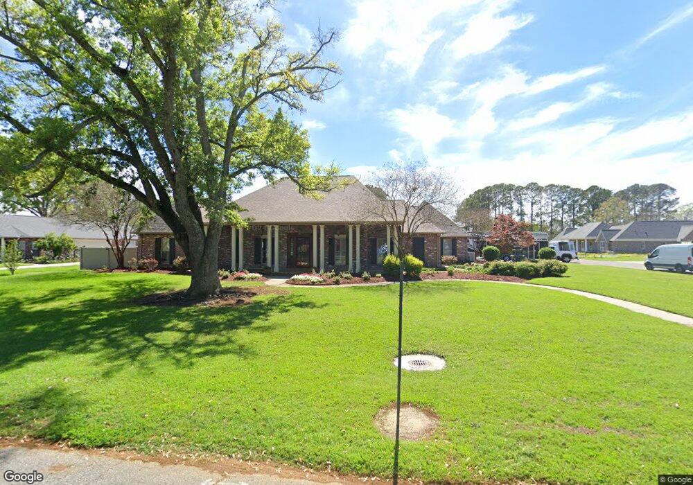
1743 Lansdown Ave Port Allen, LA 70767
West Baton Rouge Parish NeighborhoodEstimated Value: $535,000 - $766,779
--
Bed
--
Bath
3,312
Sq Ft
$199/Sq Ft
Est. Value
About This Home
This home is located at 1743 Lansdown Ave, Port Allen, LA 70767 and is currently estimated at $659,593, approximately $199 per square foot. 1743 Lansdown Ave is a home located in West Baton Rouge Parish with nearby schools including Brusly Elementary School, Lukeville Upper Elementary School, and Brusly Middle School.
Ownership History
Date
Name
Owned For
Owner Type
Purchase Details
Closed on
Mar 8, 2024
Sold by
Hoffman Jeremy P and Hoffman Amy Lemoyne
Bought by
Graham Scott Darin and Graham Lisa
Current Estimated Value
Purchase Details
Closed on
Jun 18, 2007
Sold by
Daigle Larry and Baigle Brandi Davis
Bought by
Hoffman Jeremy P and Hoffman Amy Lemoyne
Create a Home Valuation Report for This Property
The Home Valuation Report is an in-depth analysis detailing your home's value as well as a comparison with similar homes in the area
Home Values in the Area
Average Home Value in this Area
Purchase History
| Date | Buyer | Sale Price | Title Company |
|---|---|---|---|
| Graham Scott Darin | $750,000 | First American Title | |
| Graham Scott Darin | $750,000 | First American Title | |
| Hoffman Jeremy P | $55,000 | None Available |
Source: Public Records
Tax History Compared to Growth
Tax History
| Year | Tax Paid | Tax Assessment Tax Assessment Total Assessment is a certain percentage of the fair market value that is determined by local assessors to be the total taxable value of land and additions on the property. | Land | Improvement |
|---|---|---|---|---|
| 2024 | $4,118 | $50,020 | $5,610 | $44,410 |
| 2023 | $3,555 | $41,740 | $6,500 | $35,240 |
| 2022 | $4,378 | $41,740 | $6,500 | $35,240 |
| 2021 | $4,477 | $41,740 | $6,500 | $35,240 |
| 2020 | $4,070 | $37,570 | $5,850 | $31,720 |
| 2019 | $4,296 | $38,080 | $4,410 | $33,670 |
| 2018 | $4,374 | $38,080 | $4,410 | $33,670 |
| 2017 | $4,039 | $38,080 | $4,410 | $33,670 |
| 2015 | $3,235 | $37,670 | $4,000 | $33,670 |
| 2014 | $3,183 | $37,670 | $4,000 | $33,670 |
| 2013 | $2,895 | $34,270 | $4,000 | $30,270 |
Source: Public Records
Map
Nearby Homes
- 1959 Fairview Ave
- 4747 Evergreen Dr
- 2217 Silverstone Ave
- 1394 Rue Riviere
- 1152 Freeman Ln
- 2428 Riverside Dr
- Whitmore II Plan at The Woodlands
- Woodland II Plan at The Woodlands
- Whitmore I - The Woodlands Plan at The Woodlands
- Waldorf I Plan at The Woodlands
- Chadford I Plan at The Woodlands
- 2488 Oak Alley Dr
- 2607 Riverside Dr
- 4000 Lake Beau Pre Blvd Unit 198
- 4000 Lake Beau Pre Blvd Unit 69
- 4000 Lake Beau Pre Blvd Unit 110
- 4000 Lake Beau Pre Blvd Unit 13
- 4000 Lake Beau Pre Blvd Unit 87
- 4000 Lake Beau Pre Blvd Unit 131
- 5654 Ducros Dr
- 1743 Lansdowne Dr
- 1723 Lansdown Ave
- 1833 Lansdown Ave
- 4513 Robin St
- 1750 Lansdown Ave
- 1730 Lansdown Ave
- 1824 Lansdown Ave
- 1707 Lansdown Ave
- 1853 Lansdown Ave
- 1844 Lansdown Ave
- 1710 Lansdowne Dr
- 1710 Lansdown Ave
- 1781 Fairview Ave
- 1801 Fairview Ave
- 1769 Fairview Ave
- 1700 Landsdown Dr
- 1700 Lansdowne Dr
- 1738 Antonio Rd
- 1700 Lansdown Ave
- 1819 Fairview Ave