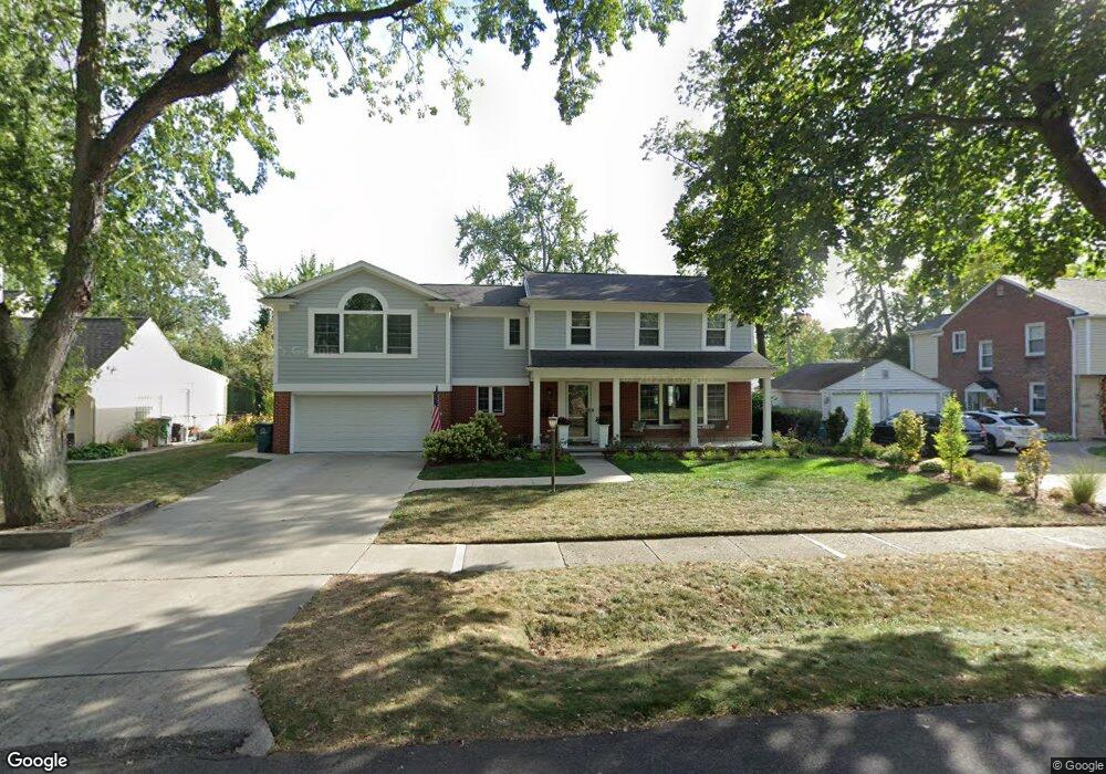
17465 Kirkshire Ave Beverly Hills, MI 48025
Estimated Value: $564,000 - $851,889
3
Beds
2
Baths
1,688
Sq Ft
$413/Sq Ft
Est. Value
About This Home
This home is located at 17465 Kirkshire Ave, Beverly Hills, MI 48025 and is currently estimated at $697,972, approximately $413 per square foot. 17465 Kirkshire Ave is a home located in Oakland County with nearby schools including Beverly Elementary School, Wylie E. Groves High School, and Berkshire Middle School.
Ownership History
Date
Name
Owned For
Owner Type
Purchase Details
Closed on
Aug 26, 2009
Sold by
Hauser Bridget
Bought by
Vanwyke Mark and Vanwyke Laina
Current Estimated Value
Purchase Details
Closed on
Jul 24, 2007
Sold by
Braus Karl G and Braus Mary H
Bought by
Hauser Bridget
Home Financials for this Owner
Home Financials are based on the most recent Mortgage that was taken out on this home.
Original Mortgage
$198,400
Interest Rate
6.73%
Mortgage Type
Purchase Money Mortgage
Create a Home Valuation Report for This Property
The Home Valuation Report is an in-depth analysis detailing your home's value as well as a comparison with similar homes in the area
Home Values in the Area
Average Home Value in this Area
Purchase History
| Date | Buyer | Sale Price | Title Company |
|---|---|---|---|
| Vanwyke Mark | $195,000 | Capital Title Ins Agency | |
| Hauser Bridget | $248,000 | Philip R Seaver Title Co Inc |
Source: Public Records
Mortgage History
| Date | Status | Borrower | Loan Amount |
|---|---|---|---|
| Previous Owner | Hauser Bridget | $198,400 |
Source: Public Records
Tax History Compared to Growth
Tax History
| Year | Tax Paid | Tax Assessment Tax Assessment Total Assessment is a certain percentage of the fair market value that is determined by local assessors to be the total taxable value of land and additions on the property. | Land | Improvement |
|---|---|---|---|---|
| 2024 | $6,778 | $368,860 | $0 | $0 |
| 2023 | $6,503 | $345,100 | $0 | $0 |
| 2022 | $7,053 | $328,030 | $0 | $0 |
| 2021 | $7,111 | $311,060 | $0 | $0 |
| 2020 | $6,265 | $306,760 | $0 | $0 |
| 2019 | $4,706 | $291,490 | $0 | $0 |
| 2018 | $6,766 | $236,650 | $0 | $0 |
| 2017 | $6,737 | $236,650 | $0 | $0 |
| 2016 | $4,496 | $143,020 | $0 | $0 |
| 2015 | -- | $131,080 | $0 | $0 |
| 2014 | -- | $115,840 | $0 | $0 |
| 2011 | -- | $99,140 | $0 | $0 |
Source: Public Records
Map
Nearby Homes
- 16975 W Fourteen Mile Rd
- 1748 Stanley Blvd
- 1850 Shipman Blvd
- 1723 Birmingham Blvd
- 1886 Henrietta St
- 955 Wakefield St
- 1626 Maryland Blvd
- 16950 Kinross Ave
- 150 Bird Ave Unit 20
- 16281 Buckingham Ave
- 1541 Shipman Blvd
- 251 E 14 Mile Rd
- 1130 Wakefield St
- 1897 Norfolk St
- 1419 Henrietta St
- 350 Catalpa Dr
- 1380 Pierce St
- 1485 Cedar Dr
- 15858 Kirkshire Ave
- 1053 Canterbury St
- 17425 Kirkshire Ave
- 17503 Kirkshire Ave
- 17450 Birwood Ave
- 17381 Kirkshire Ave
- 17400 Birwood Ave
- 17500 Birwood Ave
- 17458 Kirkshire Ave Unit Bldg-Unit
- 17458 Kirkshire Ave
- 17430 Kirkshire Ave
- 17500 Kirkshire Ave
- 17549 Kirkshire Ave
- 17360 Birwood Ave
- 17540 Birwood Ave
- 17392 Kirkshire Ave
- 17335 Kirkshire Ave
- 17560 Birwood Ave
- 17350 Kirkshire Ave
- 17550 Kirkshire Ave
- 17330 Birwood Ave
- 17401 W 14 Mile Rd