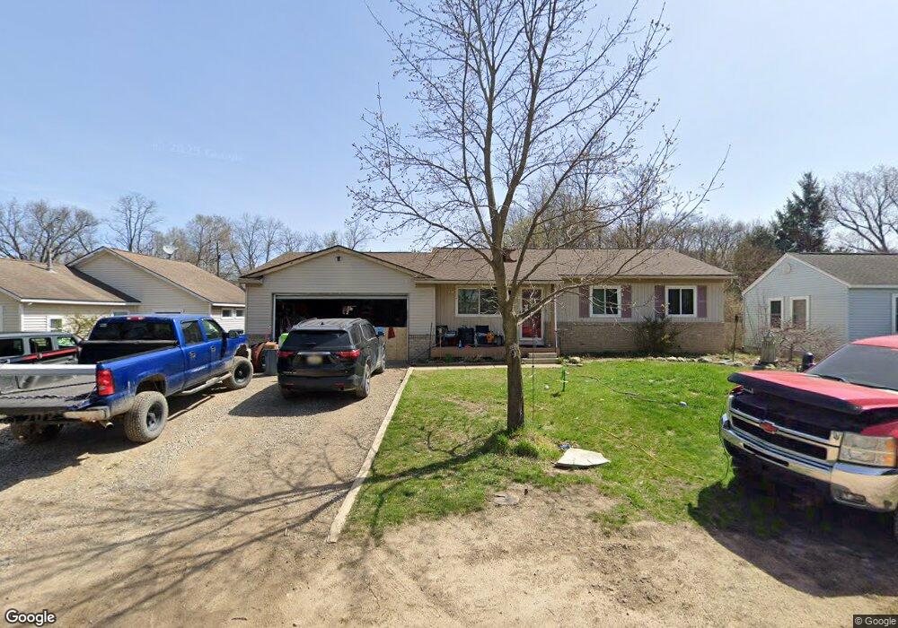
1748 Lombardy Highland, MI 48356
Estimated Value: $289,000 - $347,000
3
Beds
2
Baths
1,187
Sq Ft
$265/Sq Ft
Est. Value
About This Home
This home is located at 1748 Lombardy, Highland, MI 48356 and is currently estimated at $314,181, approximately $264 per square foot. 1748 Lombardy is a home located in Oakland County with nearby schools including Brooks Elementary School.
Ownership History
Date
Name
Owned For
Owner Type
Purchase Details
Closed on
Aug 25, 2008
Sold by
Mortgage Electronic Registration Systems
Bought by
Lasalle Bank Na
Current Estimated Value
Purchase Details
Closed on
Jul 15, 2008
Sold by
Willis Christopher
Bought by
Mortgage Electronic Registration Systems
Purchase Details
Closed on
Apr 23, 1999
Sold by
Jones Matthew K
Bought by
Willis Christopher
Home Financials for this Owner
Home Financials are based on the most recent Mortgage that was taken out on this home.
Original Mortgage
$114,000
Interest Rate
6.99%
Purchase Details
Closed on
Feb 19, 1996
Sold by
Baer Martha Dawn Jones
Bought by
Jones Matthew K
Home Financials for this Owner
Home Financials are based on the most recent Mortgage that was taken out on this home.
Original Mortgage
$87,900
Interest Rate
7.06%
Create a Home Valuation Report for This Property
The Home Valuation Report is an in-depth analysis detailing your home's value as well as a comparison with similar homes in the area
Home Values in the Area
Average Home Value in this Area
Purchase History
| Date | Buyer | Sale Price | Title Company |
|---|---|---|---|
| Lasalle Bank Na | -- | None Available | |
| Mortgage Electronic Registration Systems | $107,250 | None Available | |
| Willis Christopher | $142,500 | -- | |
| Jones Matthew K | $109,900 | -- |
Source: Public Records
Mortgage History
| Date | Status | Borrower | Loan Amount |
|---|---|---|---|
| Previous Owner | Willis Christopher | $114,000 | |
| Previous Owner | Jones Matthew K | $87,900 |
Source: Public Records
Tax History Compared to Growth
Tax History
| Year | Tax Paid | Tax Assessment Tax Assessment Total Assessment is a certain percentage of the fair market value that is determined by local assessors to be the total taxable value of land and additions on the property. | Land | Improvement |
|---|---|---|---|---|
| 2024 | $1,619 | $135,430 | $0 | $0 |
| 2023 | $1,544 | $125,650 | $0 | $0 |
| 2022 | $2,291 | $114,840 | $0 | $0 |
| 2021 | $2,175 | $106,330 | $0 | $0 |
| 2020 | $1,414 | $100,860 | $0 | $0 |
| 2019 | $2,111 | $96,380 | $0 | $0 |
| 2018 | $2,070 | $89,090 | $0 | $0 |
| 2017 | $1,988 | $89,090 | $0 | $0 |
| 2016 | $1,971 | $79,500 | $0 | $0 |
| 2015 | -- | $73,280 | $0 | $0 |
| 2014 | -- | $66,910 | $0 | $0 |
| 2011 | -- | $58,800 | $0 | $0 |
Source: Public Records
Map
Nearby Homes
- 1664 La Salle Blvd
- 3154 Lake Dr
- 1739 Ridge Rd
- 1745 Ridge Rd
- 1820 Ridge Rd
- 1625 Highland Park Dr
- 2525 Sherlock Trail
- 1412 Ormond Rd
- 1000 Waterbury Rd
- 3175 Oakridge Dr
- 2300 Canyon Ridge Dr Unit 18
- 4031 Hillcrest
- 1716 E Wardlow Rd
- 3831 Woodland Dr
- 2525 Davista Dr
- 3453 Ormond Rd
- 2160 Dean Dr
- 2286 Davista Dr
- 2295 Davista Dr
- 5246 Wayne Rd