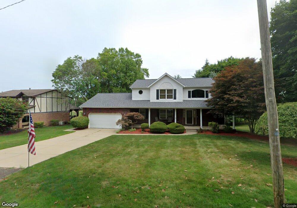
1749 Airpark Dr Louisville, OH 44641
Estimated Value: $316,000 - $405,000
3
Beds
3
Baths
2,258
Sq Ft
$155/Sq Ft
Est. Value
About This Home
This home is located at 1749 Airpark Dr, Louisville, OH 44641 and is currently estimated at $351,025, approximately $155 per square foot. 1749 Airpark Dr is a home located in Stark County with nearby schools including Louisville High School and St. Thomas Aquinas High School & Middle School.
Ownership History
Date
Name
Owned For
Owner Type
Purchase Details
Closed on
Sep 17, 2010
Sold by
Mickley Dean and Mickley Robin
Bought by
Coleman Glenn H
Current Estimated Value
Home Financials for this Owner
Home Financials are based on the most recent Mortgage that was taken out on this home.
Original Mortgage
$204,250
Outstanding Balance
$135,215
Interest Rate
4.49%
Mortgage Type
New Conventional
Estimated Equity
$215,810
Purchase Details
Closed on
Aug 16, 1993
Create a Home Valuation Report for This Property
The Home Valuation Report is an in-depth analysis detailing your home's value as well as a comparison with similar homes in the area
Home Values in the Area
Average Home Value in this Area
Purchase History
| Date | Buyer | Sale Price | Title Company |
|---|---|---|---|
| Coleman Glenn H | $215,000 | Attorney | |
| -- | $21,000 | -- |
Source: Public Records
Mortgage History
| Date | Status | Borrower | Loan Amount |
|---|---|---|---|
| Open | Coleman Glenn H | $204,250 |
Source: Public Records
Tax History Compared to Growth
Tax History
| Year | Tax Paid | Tax Assessment Tax Assessment Total Assessment is a certain percentage of the fair market value that is determined by local assessors to be the total taxable value of land and additions on the property. | Land | Improvement |
|---|---|---|---|---|
| 2025 | -- | $110,780 | $22,050 | $88,730 |
| 2024 | -- | $110,780 | $22,050 | $88,730 |
| 2023 | $2,925 | $77,250 | $16,660 | $60,590 |
| 2022 | $2,950 | $77,250 | $16,660 | $60,590 |
| 2021 | $2,958 | $77,250 | $16,660 | $60,590 |
| 2020 | $2,412 | $69,410 | $15,020 | $54,390 |
| 2019 | $2,422 | $70,880 | $15,020 | $55,860 |
| 2018 | $2,471 | $70,880 | $15,020 | $55,860 |
| 2017 | $2,193 | $61,950 | $12,040 | $49,910 |
| 2016 | $2,238 | $61,950 | $12,040 | $49,910 |
| 2015 | $2,244 | $61,950 | $12,040 | $49,910 |
| 2014 | $219 | $57,650 | $11,200 | $46,450 |
| 2013 | $1,113 | $57,650 | $11,200 | $46,450 |
Source: Public Records
Map
Nearby Homes
- 2015 E Main St
- 0 Michigan Blvd
- 1812 E Broad St
- 1170 Winding Ridge Ave
- 308 Superior St
- 910 Crosswyck Cir
- 641 S Nickelplate St
- 520 S Silver St
- 325 Lincoln Ave
- 728 E Broad St
- 2110 Edmar St
- 316 E Reno Dr
- 210 E Gorgas St
- 428 Honeycrisp Dr NE
- 3047 Mcintosh Dr NE
- 432 Honeycrisp Dr NE
- 2962 Mcintosh Dr NE
- 2963 Mcintosh Dr NE
- 430 Honeycrisp Dr NE
- 2957 Mcintosh Dr NE
- 1739 Airpark Dr
- 701 Sycamore Dr
- 1801 Airpark Dr
- 700 Sycamore Dr
- 1723 Airpark Dr
- 511 Sycamore Dr
- 1760 Washington Blvd
- 503 Sycamore Dr
- 1713 Airpark Dr
- 502 Sycamore Dr
- 1750 Washington Blvd
- 1705 Airpark Dr
- 405 Sycamore Dr
- 404 Sycamore Dr
- 1640 Yoder St
- 1704 Airpark Dr
- 1740 Washington Blvd
- 1830 Airpark Dr
- 1633 Airpark Dr
- 313 Sycamore Dr