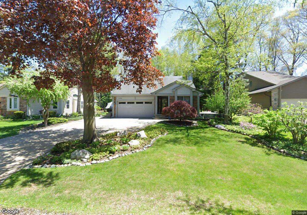
1749 Briarcliff St Sylvan Lake, MI 48320
Estimated Value: $397,000 - $443,000
3
Beds
2
Baths
1,249
Sq Ft
$334/Sq Ft
Est. Value
About This Home
This home is located at 1749 Briarcliff St, Sylvan Lake, MI 48320 and is currently estimated at $417,503, approximately $334 per square foot. 1749 Briarcliff St is a home located in Oakland County with nearby schools including Walt Whitman Elementary School, Pontiac Middle School, and Pontiac High School.
Ownership History
Date
Name
Owned For
Owner Type
Purchase Details
Closed on
Jan 23, 2008
Sold by
King Susan
Bought by
Tua King Susan C and Tua Susan C King
Current Estimated Value
Purchase Details
Closed on
Nov 8, 2002
Sold by
Silver Deborah M
Bought by
King Susan
Home Financials for this Owner
Home Financials are based on the most recent Mortgage that was taken out on this home.
Original Mortgage
$150,000
Interest Rate
6.01%
Purchase Details
Closed on
Apr 24, 2002
Sold by
Schmitt Robert J
Bought by
Markey Julia S
Create a Home Valuation Report for This Property
The Home Valuation Report is an in-depth analysis detailing your home's value as well as a comparison with similar homes in the area
Home Values in the Area
Average Home Value in this Area
Purchase History
| Date | Buyer | Sale Price | Title Company |
|---|---|---|---|
| Tua King Susan C | -- | None Available | |
| King Susan | $225,000 | -- | |
| Markey Julia S | $225,000 | -- |
Source: Public Records
Mortgage History
| Date | Status | Borrower | Loan Amount |
|---|---|---|---|
| Previous Owner | King Susan | $150,000 |
Source: Public Records
Tax History Compared to Growth
Tax History
| Year | Tax Paid | Tax Assessment Tax Assessment Total Assessment is a certain percentage of the fair market value that is determined by local assessors to be the total taxable value of land and additions on the property. | Land | Improvement |
|---|---|---|---|---|
| 2024 | $2,754 | $197,220 | $0 | $0 |
| 2023 | $2,644 | $189,440 | $0 | $0 |
| 2022 | $2,851 | $171,190 | $0 | $0 |
| 2021 | $2,741 | $164,190 | $0 | $0 |
| 2020 | $2,603 | $152,880 | $0 | $0 |
| 2019 | $2,843 | $137,650 | $0 | $0 |
| 2018 | $2,772 | $126,310 | $0 | $0 |
| 2017 | $2,757 | $124,950 | $0 | $0 |
| 2016 | $2,788 | $109,200 | $0 | $0 |
| 2015 | -- | $95,420 | $0 | $0 |
| 2014 | -- | $92,650 | $0 | $0 |
| 2011 | -- | $79,030 | $0 | $0 |
Source: Public Records
Map
Nearby Homes
- 1796 Briarcliff St
- 1775 Woodland Ave
- 2084 Woodrow Wilson Blvd Unit A6
- 2468 Walce Dr
- 2216 Middlebelt Rd
- 2230 Middlebelt Rd
- 1386 Avondale St
- 2820 Wall St
- 1253 Atkinson Ave
- 1254 Desiax Ave
- 2825 Wall St
- 1785 Ward Rd
- 2314 Middlebelt Rd
- 1660 Beechmont St
- 2630 Depew Dr
- 1970 Beechmont St
- 1160 Dorchester Ave
- 2960 Glenbroke St
- 1968 Maplewood Ave
- 1061 Dorchester Ave
- 1792 Briarcliff St
- 1765 Briarcliff St
- 2364 Avondale St W
- 2374 Avondale St W
- 1779 Briarcliff St
- 2353 Renfrew St
- 2365 Renfrew St
- 1740 Briarcliff St
- 1750 Briarcliff St
- 2358 Avondale St W
- 2341 Renfrew St
- 1821 Briarcliff St
- 1780 Briarcliff St
- 2327 Renfrew St
- 2395 Renfrew St
- 1721 Stratford St
- 1759 Stratford St
- 1733 Stratford St
- 2381 Avondale St W
- 2375 Avondale St W