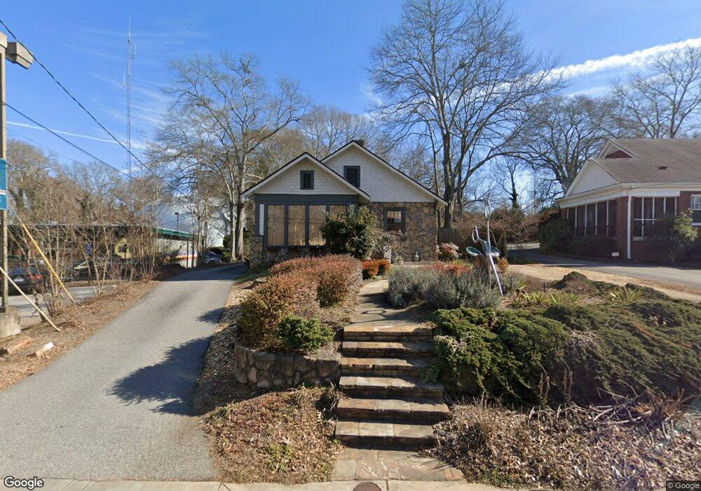
1749 S Lumpkin St Athens, GA 30606
Five Points NeighborhoodEstimated Value: $627,080 - $782,000
--
Bed
--
Bath
1,401
Sq Ft
$510/Sq Ft
Est. Value
About This Home
This home is located at 1749 S Lumpkin St, Athens, GA 30606 and is currently estimated at $714,270, approximately $509 per square foot. 1749 S Lumpkin St is a home located in Clarke County with nearby schools including Barrow Elementary School, Clarke Middle School, and Clarke Central High School.
Ownership History
Date
Name
Owned For
Owner Type
Purchase Details
Closed on
Sep 26, 2024
Sold by
Riecke Tina Eckard
Bought by
Eckard Tina Marie
Current Estimated Value
Purchase Details
Closed on
Aug 14, 1998
Sold by
Scupin Michael Lee
Bought by
Doughtery Michael E and Dough Lynne B
Purchase Details
Closed on
Jul 9, 1997
Sold by
Widner Alta Morris
Bought by
Scupin Michael Lee
Purchase Details
Closed on
Apr 7, 1995
Sold by
Widner Widner E and Widner Alta M
Bought by
Widner Alta Morris
Create a Home Valuation Report for This Property
The Home Valuation Report is an in-depth analysis detailing your home's value as well as a comparison with similar homes in the area
Home Values in the Area
Average Home Value in this Area
Purchase History
| Date | Buyer | Sale Price | Title Company |
|---|---|---|---|
| Eckard Tina Marie | -- | -- | |
| Doughtery Michael E | $118,300 | -- | |
| Scupin Michael Lee | -- | -- | |
| Widner Alta Morris | -- | -- |
Source: Public Records
Tax History Compared to Growth
Tax History
| Year | Tax Paid | Tax Assessment Tax Assessment Total Assessment is a certain percentage of the fair market value that is determined by local assessors to be the total taxable value of land and additions on the property. | Land | Improvement |
|---|---|---|---|---|
| 2025 | $6,816 | $219,530 | $72,576 | $146,954 |
| 2024 | $6,389 | $204,434 | $72,576 | $131,858 |
| 2023 | $6,389 | $188,503 | $72,576 | $115,927 |
| 2022 | $4,585 | $143,738 | $60,480 | $83,258 |
| 2021 | $4,036 | $119,766 | $60,480 | $59,286 |
| 2020 | $4,036 | $119,766 | $60,480 | $59,286 |
| 2019 | $4,066 | $119,766 | $60,480 | $59,286 |
| 2018 | $4,066 | $119,766 | $60,480 | $59,286 |
| 2017 | $3,419 | $100,709 | $60,480 | $40,229 |
| 2016 | $3,419 | $100,709 | $60,480 | $40,229 |
| 2015 | $3,326 | $97,822 | $60,480 | $37,342 |
| 2014 | $3,331 | $97,822 | $60,480 | $37,342 |
Source: Public Records
Map
Nearby Homes
- 183 Parkway Dr
- 2019 S Lumpkin St
- 275 Westview Dr
- 221 University Dr
- 997 S Milledge Ave Unit 2
- 997 S Milledge Ave Unit 3
- 997 S Milledge Ave Unit 1
- 997 S Milledge Ave Unit 4
- 1697 S Milledge Ave
- 495 Woodlawn Ave
- 204 Gran Ellen Dr
- 490 Ofarrell St
- 685 Pinecrest Dr
- 104 W Lake Ct
- 265 Annes Ct
- 115 Annes Ct
- 490 Mcwhorter Dr
- 128 Habersham Dr
- 760 E Campus Rd Unit 93
- 760 E Campus Rd Unit 95
- 1751 S Lumpkin St
- 1761 S Lumpkin St
- 1729 S Lumpkin St
- 1773 S Lumpkin St
- 1750 S Lumpkin St
- 1738 S Lumpkin St
- 145 Carlton Terrace
- 155 Carlton Terrace
- 1760 S Lumpkin St
- 1719 S Lumpkin St
- 1730 S Lumpkin St
- 165 Carlton Terrace
- 1783 S Lumpkin St
- 135 Carlton Terrace
- 1774 S Lumpkin St
- 1720 S Lumpkin St
- 175 Carlton Terrace
- 160 Milledge Terrace
- 1697 S Lumpkin St
- 156 Milledge Terrace