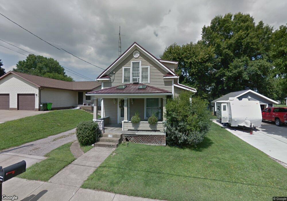
175 9th St SW Strasburg, OH 44680
Estimated Value: $163,000 - $201,000
3
Beds
2
Baths
1,244
Sq Ft
$144/Sq Ft
Est. Value
About This Home
This home is located at 175 9th St SW, Strasburg, OH 44680 and is currently estimated at $179,052, approximately $143 per square foot. 175 9th St SW is a home located in Tuscarawas County with nearby schools including Strasburg-Franklin Elementary School and Strasburg-Franklin High School.
Ownership History
Date
Name
Owned For
Owner Type
Purchase Details
Closed on
Dec 30, 1992
Sold by
Wardell Paul J and Wardell Merrie E
Bought by
Kolasa Raymond A and Kolasa Diane L
Current Estimated Value
Purchase Details
Closed on
Sep 2, 1992
Sold by
Wardell Michael L
Bought by
Wardell Paul J and Wardell Merrie E
Purchase Details
Closed on
Aug 15, 1989
Sold by
Wardell Michael L and Wardell Darlene R
Bought by
Wardell Michael L and Kolasa Diane L
Purchase Details
Closed on
Apr 8, 1988
Sold by
Daniels Bruce
Bought by
Wardell Michael L and Wardell Darlene R
Purchase Details
Closed on
Mar 1, 1988
Sold by
Robinette Mary K
Bought by
Daniels Bruce and Kolasa Diane L
Create a Home Valuation Report for This Property
The Home Valuation Report is an in-depth analysis detailing your home's value as well as a comparison with similar homes in the area
Home Values in the Area
Average Home Value in this Area
Purchase History
| Date | Buyer | Sale Price | Title Company |
|---|---|---|---|
| Kolasa Raymond A | $33,500 | -- | |
| Wardell Paul J | -- | -- | |
| Wardell Michael L | -- | -- | |
| Wardell Michael L | $29,500 | -- | |
| Daniels Bruce | $25,500 | -- |
Source: Public Records
Tax History Compared to Growth
Tax History
| Year | Tax Paid | Tax Assessment Tax Assessment Total Assessment is a certain percentage of the fair market value that is determined by local assessors to be the total taxable value of land and additions on the property. | Land | Improvement |
|---|---|---|---|---|
| 2024 | $1,781 | $44,860 | $6,620 | $38,240 |
| 2023 | $1,781 | $126,460 | $18,900 | $107,560 |
| 2022 | $1,695 | $44,261 | $6,615 | $37,646 |
| 2021 | $1,349 | $33,051 | $5,824 | $27,227 |
| 2020 | $1,273 | $33,051 | $5,824 | $27,227 |
| 2019 | $1,278 | $33,051 | $5,824 | $27,227 |
| 2018 | $1,141 | $27,880 | $4,910 | $22,970 |
| 2017 | $1,143 | $27,880 | $4,910 | $22,970 |
| 2016 | $1,143 | $27,880 | $4,910 | $22,970 |
| 2014 | $1,126 | $26,680 | $4,910 | $21,770 |
| 2013 | $1,108 | $26,680 | $4,910 | $21,770 |
Source: Public Records
Map
Nearby Homes
- 433 9th St SW
- 602 S Bodmer Ave
- 143 2nd St SE
- 3203 Mount Pleasant Rd
- 0 Dundee Strasburg Rd NW
- 0 7th St NW
- 7500 Central Rd NW
- 6269 Columbia Rd NW
- 6650 Saint Peters Church Rd NW
- 0 State Route 250 NW Unit 5161477
- 6238 Saint Peters Church Rd NW
- 0 Cherry Run Rd NW
- 1296 Russell Dr NW
- 4029 Minard Rd NW
- 5181 State Route 516 NW
- 0 Swonger Rd Unit 5161456
- 0 Swonger Rd Unit 5161457
- 971 Schneiders Crossing Rd NW
- 1242 Schneiders Crossing Rd NW Unit C
- 6113 Middle Run Rd