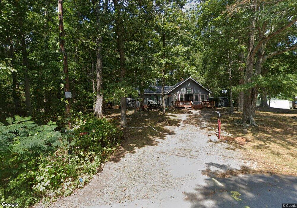
175 Alvin Dr Carrollton, GA 30117
Estimated Value: $241,298 - $289,000
3
Beds
2
Baths
1,632
Sq Ft
$164/Sq Ft
Est. Value
About This Home
This home is located at 175 Alvin Dr, Carrollton, GA 30117 and is currently estimated at $267,825, approximately $164 per square foot. 175 Alvin Dr is a home located in Carroll County with nearby schools including Central Elementary School, Central Middle School, and Central High School.
Ownership History
Date
Name
Owned For
Owner Type
Purchase Details
Closed on
Dec 21, 2006
Sold by
Huffman Amy L
Bought by
Amy L Huffman
Current Estimated Value
Purchase Details
Closed on
Dec 12, 2000
Sold by
Morehead Earl and Morehead Pat
Bought by
Huffman Amy L
Purchase Details
Closed on
Nov 4, 1999
Sold by
Romanoricz Dwight K
Bought by
Morehead Earl and Morehead Pat
Purchase Details
Closed on
Aug 16, 1978
Bought by
Romanoricz Dwight K
Create a Home Valuation Report for This Property
The Home Valuation Report is an in-depth analysis detailing your home's value as well as a comparison with similar homes in the area
Home Values in the Area
Average Home Value in this Area
Purchase History
| Date | Buyer | Sale Price | Title Company |
|---|---|---|---|
| Amy L Huffman | -- | -- | |
| Huffman Amy L | -- | -- | |
| Morehead Earl | -- | -- | |
| Morehead Earl | $75,000 | -- | |
| Romanoricz Dwight K | -- | -- |
Source: Public Records
Tax History Compared to Growth
Tax History
| Year | Tax Paid | Tax Assessment Tax Assessment Total Assessment is a certain percentage of the fair market value that is determined by local assessors to be the total taxable value of land and additions on the property. | Land | Improvement |
|---|---|---|---|---|
| 2024 | $1,514 | $87,232 | $8,000 | $79,232 |
| 2023 | $1,514 | $80,104 | $8,000 | $72,104 |
| 2022 | $1,274 | $65,855 | $8,000 | $57,855 |
| 2021 | $1,158 | $57,619 | $8,000 | $49,619 |
| 2020 | $1,065 | $52,388 | $8,000 | $44,388 |
| 2019 | $983 | $47,520 | $8,000 | $39,520 |
| 2018 | $902 | $42,533 | $8,000 | $34,533 |
| 2017 | $904 | $42,533 | $8,000 | $34,533 |
| 2016 | $905 | $42,533 | $8,000 | $34,533 |
| 2015 | $888 | $38,691 | $6,000 | $32,691 |
| 2014 | $891 | $38,691 | $6,000 | $32,691 |
Source: Public Records
Map
Nearby Homes
- 400 Stripling Chapel Rd
- 50 Azalea Trail
- 1585 Hays Mill Rd
- 1250 Hays Mill Rd
- 977 Whooping Creek Rd
- 111 Vineyard Walk
- 111 Vineyard Walk Unit LOT 78
- 113 Vineyard Walk
- 113 Vineyard Walk Unit LOT 77
- 121 Carson Place
- Plan 1643 at Windmill Park
- Plan 1830 at Windmill Park
- 203 Vineyard Walk Unit LOT 74
- Plan 2030 at Windmill Park
- 203 Vineyard Walk
- Plan 1727 at Windmill Park
- Plan 1400 at Windmill Park
- 116 Manor Way
- 135 Gray Rd