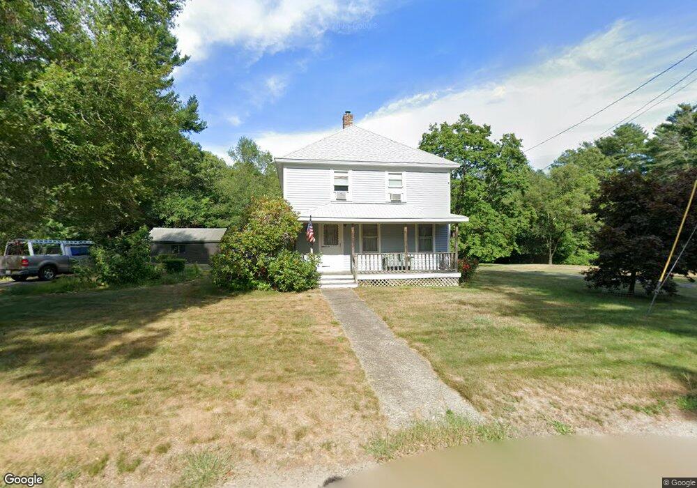
175 Berry St Wrentham, MA 02093
Estimated Value: $597,000 - $632,000
3
Beds
1
Bath
1,779
Sq Ft
$342/Sq Ft
Est. Value
About This Home
This home is located at 175 Berry St, Wrentham, MA 02093 and is currently estimated at $608,027, approximately $341 per square foot. 175 Berry St is a home located in Norfolk County with nearby schools including Delaney Elementary School, Charles E Roderick, and Discovery Daycare Center.
Ownership History
Date
Name
Owned For
Owner Type
Purchase Details
Closed on
Aug 23, 2022
Sold by
Boothe Alan H
Bought by
Boothe Ft
Current Estimated Value
Purchase Details
Closed on
Apr 27, 1972
Bought by
Boothe Alan H
Create a Home Valuation Report for This Property
The Home Valuation Report is an in-depth analysis detailing your home's value as well as a comparison with similar homes in the area
Purchase History
| Date | Buyer | Sale Price | Title Company |
|---|---|---|---|
| Boothe Ft | -- | None Available | |
| Boothe Alan H | -- | -- |
Source: Public Records
Mortgage History
| Date | Status | Borrower | Loan Amount |
|---|---|---|---|
| Previous Owner | Boothe Alan H | $40,000 | |
| Previous Owner | Boothe Alan H | $40,000 |
Source: Public Records
Tax History
| Year | Tax Paid | Tax Assessment Tax Assessment Total Assessment is a certain percentage of the fair market value that is determined by local assessors to be the total taxable value of land and additions on the property. | Land | Improvement |
|---|---|---|---|---|
| 2025 | $6,250 | $539,300 | $288,000 | $251,300 |
| 2024 | $5,996 | $499,700 | $288,000 | $211,700 |
| 2023 | $5,919 | $469,000 | $261,900 | $207,100 |
| 2022 | $5,815 | $425,400 | $255,100 | $170,300 |
| 2021 | $5,714 | $406,100 | $238,400 | $167,700 |
| 2020 | $4,922 | $345,400 | $182,000 | $163,400 |
| 2019 | $4,549 | $322,200 | $163,800 | $158,400 |
| 2018 | $4,514 | $317,000 | $163,600 | $153,400 |
| 2017 | $4,242 | $297,700 | $160,500 | $137,200 |
| 2016 | $4,061 | $284,400 | $155,800 | $128,600 |
| 2015 | $3,935 | $262,700 | $149,800 | $112,900 |
| 2014 | $3,870 | $252,800 | $144,100 | $108,700 |
Source: Public Records
Map
Nearby Homes
- 1222 South St
- 0 Berry St
- 18 Huntington Ave
- 19 Chestnut Lot 0
- 160 Washington St Unit 22
- 158 Washington St
- 126 Washington St
- 130 Washington St
- 124 Washington St
- 20 Field Cir
- 613 West St
- 10 Earle Stewart Ln Unit Lot 5
- 11 Crestwood Ave
- 3 Earle Stewart Ln
- 12 Earle Stewart Ln
- 2 Earle Stewart Ln
- 11 Amber Dr
- 440 Chestnut St
- 46 Mirimichi St
- 19 Valerie Dr
Your Personal Tour Guide
Ask me questions while you tour the home.